Bryan Norcross: Keeping an eye on the Gulf, Philippe and Invest 91L in the Atlantic
Midway between the northeastern Caribbean islands and Africa, Tropical Storm Philippe is steadily heading west in the general direction of the islands. The ocean is very warm, and the atmosphere is moist, but the upper-level winds are currently fairly hostile, so Philippe is not forecast to strengthen very much in the short term.

FOX Weather is your Hurricane HQ, streaming free 24/7.
(FOX Weather / FOX Weather)
Updated at 9:30 a.m. EDT on Tuesday
One maybe in the Gulf and two systems to watch in the Atlantic, both with difficult forecasts.
Tropical Disturbance #1 is loosely related to the front that was associated with the precursor system to Tropical Storm Ophelia combined with a sharp dip in the jet stream south into the western Caribbean. The disturbance, such that it is, is broad and ill-defined with hostile upper winds spreading the thunderstorms out.
Today or tomorrow, the system is expected to move under the jet stream dip as it tracks to the west over or near the tip of Mexico’s Yucatán Peninsula. The hostile upper winds should let up at that time, giving the system a slight chance to develop if it’s over the Gulf waters. But even if all that comes together, by late tomorrow, the atmospheric environment over the Gulf of Mexico is forecast to become too hostile for the system to maintain itself, and it would likely dissipate.
The National Hurricane Center is only giving it a very slight chance of getting organized into a tropical depression over the next day or two. There is no apparent threat to land beyond the gusty thunderstorms that will likely affect the northern Yucatán.
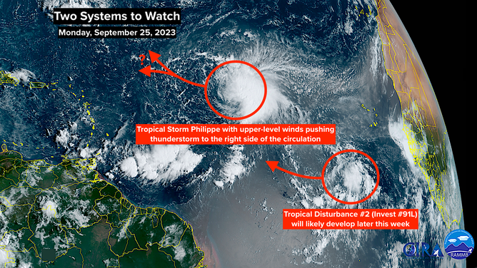
A satellite image of Tropical Storm Philippe and Invest 91L on Monday, September 25, 2023.
(NOAA)
Midway between the northeastern Caribbean islands and Africa, Tropical Storm Philippe is steadily heading west in the general direction of the islands. The ocean is very warm, and the atmosphere is moist, but the upper-level winds are currently fairly hostile, so Philippe is not forecast to strengthen very much in the short term.
The National Hurricane Center’s forecast and the consensus of the long-range computer models turn Philippe to the north well before it gets to the Caribbean, but there are imaginable scenarios that would allow it to make a more gradual turn and jog west, coming uncomfortable close to the islands. Nothing would happen quickly, so in a few days, we’ll have to be sure it makes the turn as forecast.
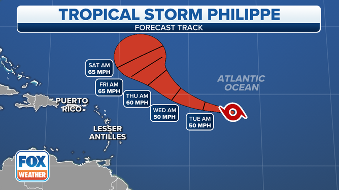
The forecast track of Tropical Storm Philippe.
(FOX Weather)
The path the storm takes appears to be related to how strong it gets. A weaker storm is more likely to track farther south. So the current indications are that Philippe would not be very strong if did affect the northeast Caribbean. Since the future strength is dependent on the degree to which the slightly hostile atmospheric environment counteracts the extra-warm ocean, the track has more uncertainty than normal.
Behind Philippe, Tropical Disturbance #2 – officially tagged Invest 91L – is likely to develop into at least a tropical depression in the next several days. Initially, the system should lift to the north, but it’s starting farther south than Philippe did. A parade of strong jet stream dips will move across the central part of the Atlantic. The dips tend to pull well-developed systems north, but weaker storms often just get a little tug as they pass by.
The bottom line is the long-range computer forecasts for this system are all over the place as well – from uncomfortably close to the islands to far out to sea. On average, forecasts for undeveloped systems have higher uncertainty, so there are no conclusions to reach yet. In any case, the steering flow is relatively weak, so nothing will happen fast.
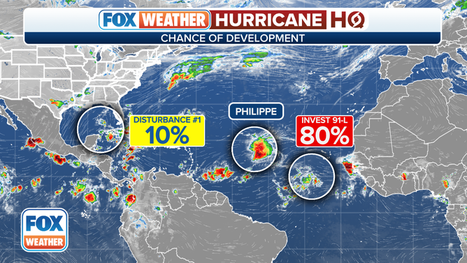
An overview of the tropical Atlantic Ocean on Monday, September 25, 2023.
(FOX Weather)
We’re getting close to the end of the Cabo Verde part of the hurricane season when we watch the eastern Atlantic for systems that came off Africa. Until the end of the season, we’ll keep a closer eye on the western Caribbean and the Gulf of Mexico.