Bryan Norcross: Watching for Vince later this week
This is the same strong front that moved off the East Coast of the U.S. last week. Winds with the system are forecast to exceed 40 mph. So far, the system has been powered by the contrast of the cold air behind it and the warm air in front.

FOX Weather is your Hurricane HQ, streaming free 24/7.
(FOX Weather)
Updated Tuesday at 9 a.m. EST
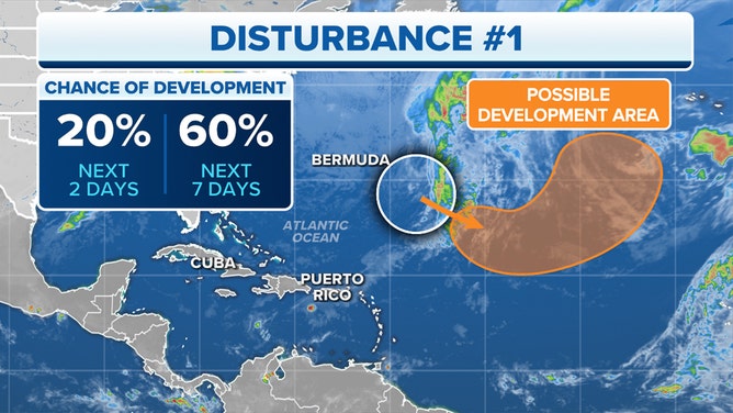
A low-pressure system is strengthening in the central Atlantic associated with a cold front that extends south to Puerto Rico. This is the same strong front that moved off the East Coast of the U.S. last week. Winds with the system are forecast to exceed 40 mph. So far, the system has been powered by the contrast of the cold air behind it and the warm air in front.
Over the next few days, the low is forecast to track south over warm ocean water, which will immerse the system in tropical air washing out the front. The system will then derive at least some of its energy from the tropical ocean. These systems with hybrid power sources and winds over 40 mph are called subtropical storms. And they get an official name.
Chance of development in the Atlantic.
(FOX Weather)
The National Hurricane Center gives the system a medium chance of taking on some tropical characteristics. Assuming the forecast of at least 40 mph winds is correct, it will get the name Subtropical Storm Vince. It could become a purely tropical storm if it tracks over the warm waters long enough. In any case, it won’t threaten land.
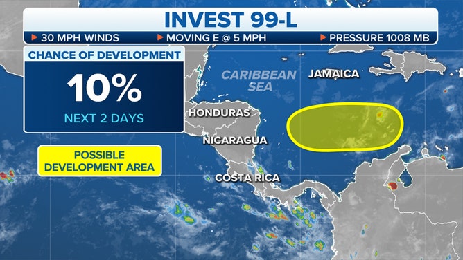
In the Caribbean, off the northern tip of Colombia, a well-defined swirl of clouds is moving slowly west toward Central America. The disturbance is officially designated Invest 99L.
Chance of development in the Caribbean Sea.
(FOX Weather)
The atmosphere across the Caribbean is very dry, so the National Hurricane Center is only giving it a slight chance of developing into a tropical depression. The threat with a system like this is normally flooding in the high terrain, but the moisture in this case is extremely limited.
Otherwise, the tropics are in a wintertime posture.