Bryan Norcross: Tammy slowly pulling away from the Caribbean and another disturbance could develop
Tammy still has a large active tail extending south across the Caribbean islands, which will persist for at least a couple of days. Tropical downpours with occasional gusty winds will pass over the islands as tropical moisture is drawn north into the storm.

FOX Weather is your Hurricane HQ, streaming free 24/7.
(FOX Forecast Center / FOX Weather)
Hurricane Tammy has found a supportive patch atmosphere well north of the Caribbean.
The storm has responded by expanding in size a bit, and it temporarily looks more organized. Tammy still has a large active tail extending south across the islands, which will persist for at least a couple of days. Tropical downpours with occasional gusty winds will pass over the islands as tropical moisture is drawn north into the storm.
There is a lot of confidence in the forecast track of Tammy over the next couple of days. The storm will slowly move to the north and northeast, well away from land. After that, it’s a bit of a crapshoot.
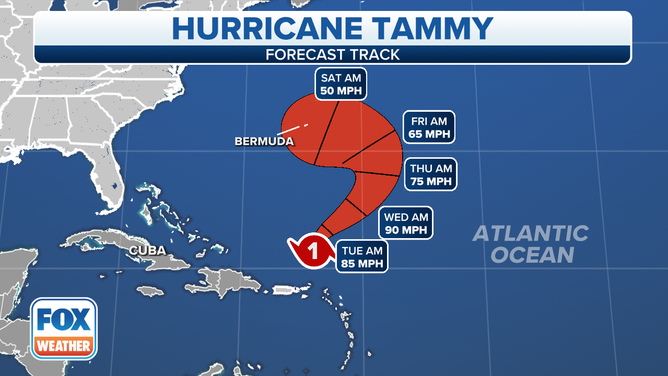
The forecast track for Hurricane Tammy.
(FOX Weather)
The consensus of the various computer forecasts is that a large upper-level low-pressure system will develop over the waters between the U.S. Southeast coast and Tammy. How that giant weather feature will interact with the hurricane is an open question.
One possibility is that the upper low will simply kick Tammy out to sea, where it will die with the fish. Another possibility is that Tammy will be scooped up in the flow around the low, so the storm rotates back to the west, perhaps passing near Bermuda.
The National Hurricane Center is favoring the second scenario, but they acknowledge that there’s high uncertainty in the forecast.
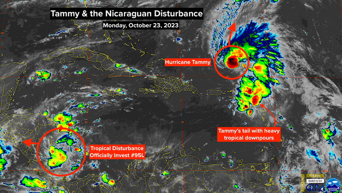
A satellite image of Hurricane Tammy and Invest 95L on Monday, October 23, 2023.
(NOAA)
If the upper low traps the storm, it appears likely that Tammy’s circulation will get overwhelmed by dry air and hostile upper winds, and Tammy will essentially be absorbed into the non-tropical system. If what’s left of Tammy comes near Bermuda, it would be significantly weakened in this scenario.
In the long range, some computer models develop a new disturbance out of the upper low/ex-Tammy combo, but it doesn’t appear it would be a tropical system at this time. We’ll just have to see how all this plays out.
In any case, cold fronts and dry air pushing off the eastern and southeastern parts of the U.S. will keep any tropical systems away for the foreseeable future – hopefully for the rest of hurricane season.
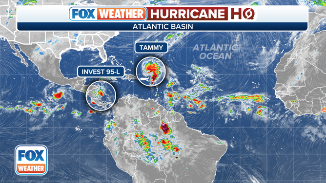
An overview of the tropical Atlantic Ocean on Monday, October 23, 2023.
(FOX Weather)
In the far southern Caribbean, a tropical disturbance – officially tagged Invest 95L – has a medium chance of developing into a short-lived tropical depression before it moves ashore in Nicaragua by tomorrow. There’s a slight chance it could become Tropical Storm Vince. In any case, it will bring very heavy rain to Central America.
Elsewhere, the tropics are covered by dry air as we slowly transition toward a wintertime weather pattern.