Bryan Norcross: Nasty East Coast storm developing off Florida & a fuzzy forecast for the Atlantic disturbance
On the current schedule, the winds pick up at the immediate coastline in the Carolinas by tomorrow morning, with gusty rain moving across coastal areas during the day. Periods of heavy rain are possible late. Winds in exposed areas at the coast could gust to 40 to 50 mph. The rain and wind spread through the mid-Atlantic into the Northeast Friday night and Saturday as the system heads north, paralleling the coast.

FOX Weather is your Hurricane HQ, streaming free 24/7.
(FOX Weather / FOX Weather)
Updated at 9:30 a.m. EDT on Thursday
Disturbance #1, a non-tropical low-pressure center, is in the formation stages over the warm ocean off the Central Florida coast. Its seeds were an old front that stalled across the peninsula and a strengthening upper-level disturbance in the southern branch of the jet stream. The system is forecast by several of the computer forecast models to strengthen significantly as it drifts toward the North Carolina coast tomorrow into Saturday.
On the current schedule, the winds pick up at the immediate coastline in the Carolinas by tomorrow morning, with gusty rain moving across coastal areas during the day. Periods of heavy rain are possible late. Winds in exposed areas at the coast could gust to 40 to 50 mph.
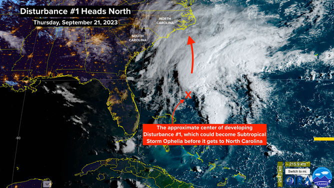
A satellite image of Invest 99L off the southeastern U.S. coast on Thursday, September 21, 2023.
(NOAA)
The rain and wind spread through the mid-Atlantic into the Northeast Friday night and Saturday as the system heads north, paralleling the coast.
It looks likely that the system will weaken on Sunday but keep unsettled weather over the Northeast.
There is a decent chance that the non-tropical low will separate itself from its parent frontal system before it gets to the Carolina coast. If it has sufficient organization and the winds related to the circulation are at least 40 mph, the National Hurricane Center will name it Subtropical Storm Ophelia.
Whether or not it gets named, nasty conditions appear likely along a good part of the East Coast over the next 2 to 3 days. The strong onshore winds will push water toward land, which will cause some coastal flooding around high tides in low-lying areas. Stay aware of local alerts and forecasts.
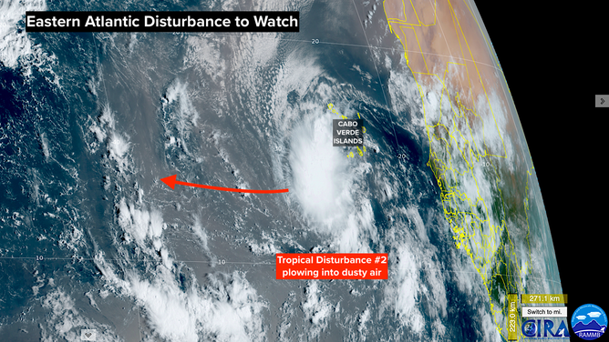
A satellite image of a tropical disturbance in the far eastern Atlantic Ocean on Thursday, September 21, 2023.
(NOAA)
On the far side of the ocean, Tropical Disturbance #2 is pushing west into the tropical Atlantic. The National Hurricane Center is giving it a high chance of developing into a tropical depression or tropical storm over the next several days as it tracks in the general direction of the Caribbean islands.
The system will have to fight off some dust and dry air to develop, but the long-range computer forecasts show the system eventually turning into at least a tropical storm. Some show it becoming a strong hurricane.
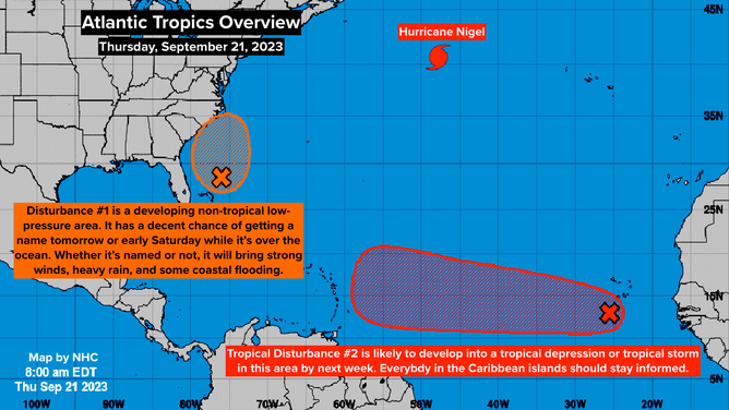
An overview of the tropical Atlantic Ocean on Thursday, September 21, 2023.
(FOX Weather)
The long-range tracks have a lot of spread. Many of them turn the storm north before it reaches the islands, but others show tracks that are too close for comfort. On the current schedule, the system would be in the general vicinity of the northeastern Caribbean Wednesday or Thursday of next week, so there's still plenty of time.
Also, remember that forecasts for systems that haven't developed or are just developing have much greater intrinsic errors in their forecasts, so changes are likely.
For now, everybody in the islands just needs to stay informed.
In the middle of the Atlantic, Hurricane Nigel is weakening as it heads north into colder water.