Bryan Norcross: Idalia exits into the Atlantic today after ripping across the Southeast
Idalia dashed across North Florida, South Georgia, and the coastal Carolinas in less than 36 hours, but in the days ahead, its forward motion will slow to a crawl as the strong steering currents collapse. At the end of the week, the storm is forecast to be drifting around as a mid-level tropical storm in the waters southwest of Bermuda

FOX Weather is your Hurricane HQ, streaming free 24/7.
(FOX Weather / FOX Weather)
Updated at 9 a.m. ET on Thursday, Aug. 31:
Tropical Storm Idalia is heading into the Atlantic, although its circulation is still affecting coastal North Carolina. Some flooding is still possible due to heavy rain inland. In addition, ocean water will push into rivers and inlets and onto beaches this morning up to 4 feet about normal high tide. The effects will slowly subside this afternoon.
Idalia dashed across north Florida, south Georgia, and the coastal Carolinas in less than 36 hours, but in the days ahead, its forward motion will slow to a crawl as the strong steering currents collapse. At the end of the week, the storm is forecast to be drifting around as a mid-level tropical storm in the waters southwest of Bermuda.
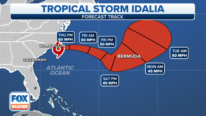
The forecast track of Tropical Storm Idalia.
(FOX Weather)
The long-range is fuzzy, as it often is when a system is left adrift in calm atmospheric winds. A couple of days ago, some computer forecasts turned a weak version of Idalia back toward Florida. Now, the general consensus is that it will eventually turn north. A loop back near the Northeast coast can’t be ruled out, but the odds currently favor it eventually turning out to sea. It’s too early to know for sure. Nothing will happen fast.
Even though many thousands of homes and businesses were severely impacted by Hurricane Idalia yesterday, we were lucky that it wasn’t a lot worse. The storm hit the least-populated part of the Florida coast, where large stretches are nature preserves. That prevented the highest storm surge from directly impacting the millions of people who live just to the south.
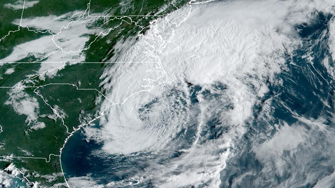
A satellite image of Tropical Storm Idalia on Thursday, August 31, 2023.
(NOAA)
In addition, the storm was in a weakening stage in the last hour before it came ashore – likely due to processes within the system, which are not forecastable. That might have taken the edge off the winds pushing the water inland at landfall, but we’ll await the National Hurricane Center’s final analysis.
Hopefully, Idalia was a big wake-up call for many people in the Tampa Bay region. This was just a preview of what can happen when a hurricane makes landfall north of the mouth of the Bay. The water gets pushed in, overflows onto streets and into neighborhoods, and can’t get out until the winds let up. We were very fortunate that the track wasn’t a little farther south (Idalia’s center went in some 130 miles north), or the storm wasn’t larger in diameter. The water would have been several to many feet higher around the Bay and over the beaches.
As it was, recovery will be difficult for many people impacted by Idalia.
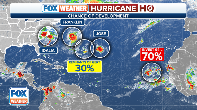
An overview of the tropical Atlantic Ocean.
(FOX Weather)
Elsewhere in the Atlantic, Hurricane Franklin and new Tropical Storm Jose are not threats. Neither are the other two systems the National Hurricane Center is noting for possible development. We’ll just keep half an eye on Idalia to be sure it heads out to sea next week.