Bryan Norcross: Hurricane season starts with tropical depression in Gulf and big question about El Nino
The spin in the air aloft induced a low-pressure system at the surface that found a small patch of marginally conducive atmosphere that allowed it to organize enough to be called a depression. But could tropical systems be limited this year with El Nino's increased wind shear? Or will the super-warmed Atlantic waters overcome the disadvantage?

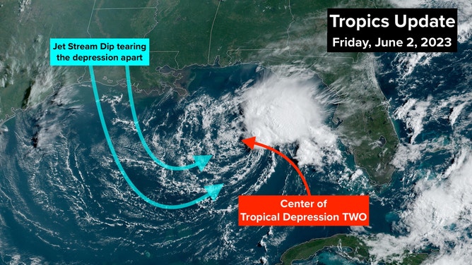
MIAMI – Tropical Depression TWO formed out of a disturbance in the northern Gulf of Mexico that was initially triggered by a sharp dip in the jet stream.
The spin in the air aloft induced a low-pressure system at the surface that found a small patch of marginally conducive atmosphere that allowed it to organize enough to be called a depression. (An oddball storm formed back in January in the North Atlantic that took the ONE spot.)
The difference between a tropical depression, which has winds of less than 40 mph, and a tropical storm with winds of 40 mph or higher is a fine line. If the upper-level winds let up just briefly, the system could become Tropical Storm Arlene, but it won’t make any difference.
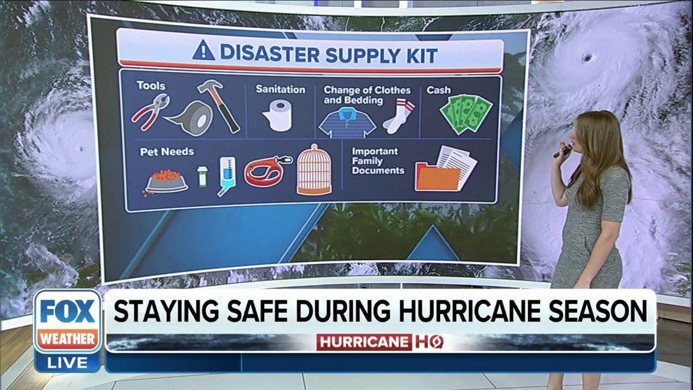
Preparation tips for hurricane season
The FOX Forecast Center has tips for preparing yourself for hurricane season.
WHAT’S THE DIFFERENCE BETWEEN A TROPICAL DEPRESSION VS. TROPICAL STORM VS. HURRICANE?
As the system tracks to the south through the Gulf, the upper winds will become increasingly hostile, which should start to rip the circulation apart late Friday. The National Hurricane Center is forecasting the system to dissipate by late Saturday.
(FOX Weather)
The thunderstorms associated with Tropical Depression Two, or Tropical Storm Arlene if it briefly becomes that, are confined to the Gulf of Mexico. The circulation around the system is pulling excess tropical moisture over the Florida peninsula. That moisture, combined with the dip in the jet stream over the Gulf, will trigger extra-heavy thunderstorms again Friday. As a result, the National Weather Service has issued a Flood Watch for part of the state.
By late Saturday, both the depression, or what’s left of it, and the extra-heavy-rain ingredients will move into the Atlantic, and a more typical June weather pattern will take over in Florida.
Tug of war to determine Atlantic Hurricane Season's fate
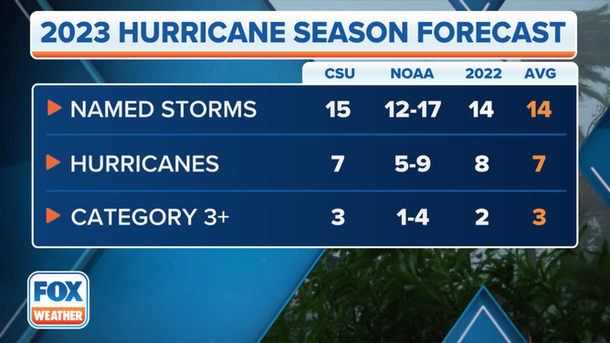
Hurricane Season began Thursday, of course. Colorado State University forecasters updated their seasonal forecast by increasing the numbers slightly. The thinking about the season is the same, however.
(FOX Weather)
The equatorial Pacific waters south of Hawaii are forecast to warm, which causes hostile upper winds over the Atlantic, which normally limit storm development. The phenomenon is called an El Niño. At the same time, the tropical Atlantic is exceptionally warm, which means systems will have more fuel to develop.
EL NINO, CLIMATE CHANGE TO LIKELY MAKE NEXT 5 YEARS HOTTEST RECORDED ON EARTH, WMO SAYS
It comes down to which force will be stronger. If the Pacific waters warm dramatically, the hostile winds will likely limit the number of systems that can develop, even with the extra Atlantic energy. But if the Pacific ends up only moderately warm, the excess Atlantic heat might overcome the negative effects of a modest El Niño.
It’s like a tug of war. And since we don’t know if one or the other will win, the forecasts for this hurricane season have been more-or-less right down the middle – close to average.
WHAT ARE EL NINO AND LA NINA CLIMATE PATTERNS?
Even if the storm-squashing El Niño is strong, however. The hostile winds can briefly let up enough for a powerful hurricane to form. And in general, the El Niño has the least effect on storms developing in the Gulf of Mexico.
So regardless of the forecast, it’s up to everybody in the hurricane zone to have their plans in place and stay informed.