Bryan Norcross: Shocking Hurricane Otis resonates with forecasters and emergency planners
We’ve seen the story before, but never this extreme version. The four Category 5 hurricanes that have hit the U.S. in the last 100 years were all at tropical storm intensity two days before landfall.

FOX Weather is your Hurricane HQ, streaming free 24/7.
(FOX Weather)
Updated on Thursday at 9:30 a.m. EDT
The way Hurricane Otis played out early yesterday in Acapulco is the type of scenario that most challenges forecasters and keeps emergency managers awake at night. We’ve seen the story before, but never this extreme version. The four Category 5 hurricanes that have hit the U.S. in the last 100 years were all at tropical storm intensity two days before landfall.
Otis was a 50-mph tropical storm ONE day before landfall and was not even forecast to reach hurricane strength before coming ashore. Its intensity increased a stunning 115 mph in the 24 hours before it hit Acapulco head-on as a Category 5 – with most of that increase coming in the final afternoon and evening before it crossed the coast at 1:30 AM local time.
Even 12 hours before, the forecast only called for Otis to intensify into a 90-mph hurricane. The winds are estimated to have been 165 mph at landfall.
HOW DID HURRICANE OTIS' RECORD INTENSIFICATION CATCH ADVANCED FORECAST MODELS BY SURPRISE?
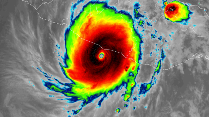
Infrared satellite image shows Category 5 Hurricane Otis approaching Acapulco on Oct. 24, 2023.
(RAAM-B / CIRA / NOAA)
Hurricane Hunters flew into Otis Tuesday afternoon and shockingly found that storm wasn’t the 80-mph hurricane that was estimated by analyzing the satellite images, but instead an intensifying 110-mph hurricane on the way to 125 mph just two hours later.
By that afternoon, the computer forecasts had caught up to the idea that the odds of Otis rapidly intensifying were much higher than average. There was no significant hint of it in the morning data.
The obvious question is, what could have been done differently? Given the data available, the official forecasts were appropriate. The most obvious missing component of the storm monitoring system was radar. In the U.S., approaching storms are monitored by an extensive network of coastal National Weather Service radars that reach out about 150 miles. There is no radar covering the Acapulco area.
In fairness to the Mexican decision-makers, Acapulco hasn’t been hit by a landfalling hurricane since 1951. The primary natural threat there is earthquakes. It would naturally be a lower-priority location than other areas where hurricanes are frequent.
In addition, Hurricane Hunters were there 23 hours before landfall, so radar would have given only slightly more warning that Otis was organizing quickly.
If a system like Otis were approaching the U.S. coast, NOAA would have deployed more Hurricane Hunter flights and other atmosphere-measuring resources that might have helped the various computer forecasts pick up on the pristine environment that must have surrounded Otis during that last day. But storms that super-intensify in the last 12 to 18 hours before landfall will always be an extreme challenge.
From a communications standpoint, the National Weather Service could consider issuing a Hurricane Emergency – something of a super-high-profile Hurricane Warning – for these off-the-charts situations. That might alert people that something extraordinary is happening and immediate action is required.
In the end, however, an Otis-like storm is the most challenging scenario that forecasters and emergency planners face in the hurricane zone.
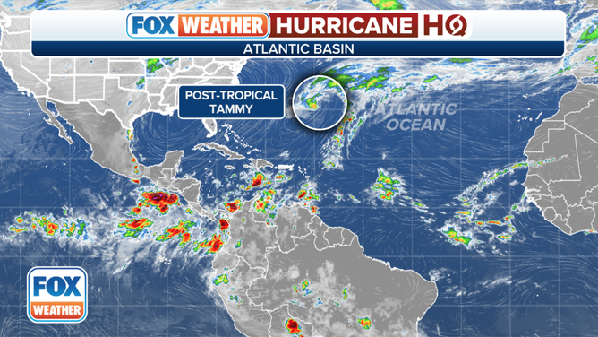
(Ex-Tammy is forecast to meander around the ocean near Bermuda. / FOX Weather)
In the Atlantic, Tammy is now a hurricane-strength non-tropical system officially called Post-Tropical Cyclone Tammy. It has merged with a front that moved off the U.S. East Coast.
Ex-Tammy is forecast to meander around the ocean near Bermuda, which looks likely to receive high wind and tropical squalls over the next couple of days.
As Ex-Tammy sits over the warm ocean, the frontal components of the system might dissipate so Tammy can regain some tropical characteristics. The National Hurricane Center is giving that a 30% chance of happening. In any case, most forecasts indicate that Tammy will eventually head out to sea.
We’ll keep an eye on the Caribbean. Some long-range computer forecasts show the possibility of something eventually developing there.