Bryan Norcross: Hurricane Nigel is strengthening and a chance of development near the East Coast this weekend
The system will likely move north over or near the coastline spreading rain and gusty winds as it plows into high pressure to the north. Computer forecasts show a variety of tracks, some involving land, but some over the warm water of the Gulf Stream just offshore.

FOX Weather is your Hurricane HQ, streaming free 24/7.
(FOX Weather / FOX Weather)
Updated at 8:30 a.m. on Monday
At the end of the week, a non-tropical low-pressure system is forecast to form off the east coast of Central or North Florida from an old cold front and an upper-level disturbance. The system will likely move north over or near the coastline spreading rain and gusty winds as it plows into high pressure to the north. Computer forecasts show a variety of tracks, some involving land, but some over the warm water of the Gulf Stream just offshore.
The National Hurricane Center is giving the system a low chance of acquiring some tropical characteristics and becoming a subtropical storm – a hybrid-type system. If the system’s track is offshore, it will be over very warm water until it reaches around the Delmarva peninsula east of Washington, D.C.
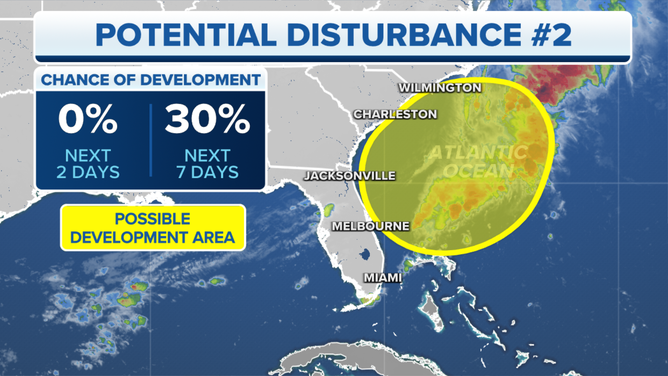
A potential tropical disturbance has a low chance of developing over the next week.
(FOX Weather)
The system could extract enough heat from the warm ocean to develop something of a tropical core, although the time window is fairly short, and the storm would have to separate itself from its associated cold front. This is why the odds of subtropical development are still low.
Whether it technically becomes Subtropical Storm Ophelia or not, the results along the East Coast will be the same. It’s too early to know the extent of the rain and wind because it is dependent on the track of the system. This would essentially be a warm-season nor’easter.
The cold front draped across Central Florida that’s associated with the coastal storm moving north today with be the seed of the next system. It is waiting on an upper-air disturbance that’s currently offshore of California to meet up about Friday. As with all systems that have not developed yet, the forecasts are subject to change.
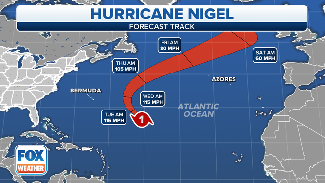
The forecast track for Hurricane Nigel.
(FOX Weather)
In the middle of the Atlantic, Hurricane Nigel is rapidly strengthening. The National Hurricane Center forecasts it to eventually reach Category 3. Its forecast track is comfortably east of Bermuda, so it shouldn’t be a direct threat to land. Once again, however, a strong hurricane in the Atlantic will cause dangerous conditions in the surf along the East Coast later this week.
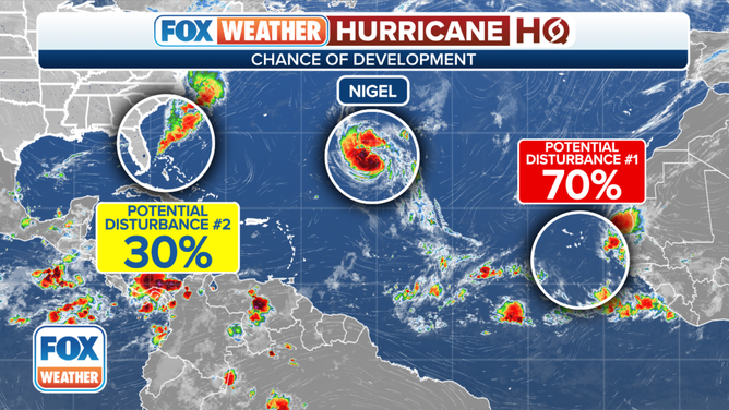
An overview of the tropical Atlantic Ocean on Monday, September 18, 2023.
(FOX Weather)
In a day or two, a disturbance is forecast to move off the African coast. The National Hurricane Center is giving it a high chance of developing into at least a tropical depression over the Atlantic later this week.
There is currently no sign of the disturbance becoming a threat to land, but it bears watching. Long-range forecasts for systems that haven’t yet developed are always iffy.