Bryan Norcross: Hurricane Lee's impacts begin on the U.S. East Coast today then increase through the week
Most computer forecasts and the National Hurricane Center's cone bring the center of Lee close enough to the New England coast that significant impacts are increasingly likely

FOX Weather is your Hurricane HQ, streaming free 24/7.
(FOX Weather / FOX Weather)
Updated 9:20 a.m. ET Tuesday
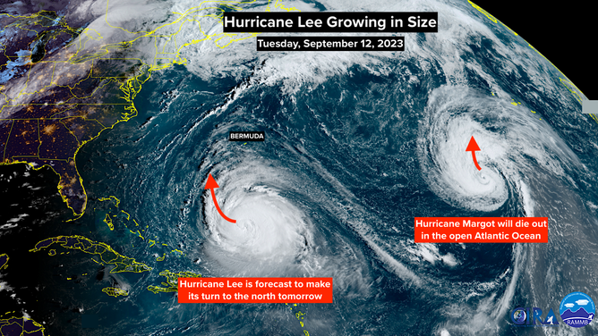
Hurricane Lee is growing in diameter as it creeps to the west, well north of the Caribbean Islands. The top winds decreased in intensity a little yesterday as the core of the hurricane grew in size. The total energy in the storm didn't change much, but it spread out. Larger storms move more water in the ocean, which means more strong swells pushing toward the East Coast.
Most computer forecasts and the National Hurricane Center's cone bring the center of Lee close enough to the New England coast that significant impacts are increasingly likely. Lee will continue to increase in size, and the jet stream dip propelling it north will also enhance the wind and rain on the left side of the storm – the side closest to or over the coast. Winds gusting to hurricane force and torrential rain are possible in a corridor that includes Boston.
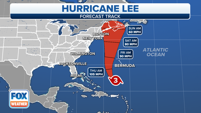
The forecast track for Hurricane Lee.
(FOX Weather)
The ground is saturated along the I-95 corridor, which would aggravate the flooding threat if the band of heavy rain in Lee's circulation rakes the coast.
Cape Cod sticks out closer to the hurricane's projected path, so even worse conditions are possible there. Also, if Lee tracks just offshore of the Cape, strong winds will push ocean water south into Cape Cod Bay and into the harbors, rivers, and inlets along the coast of southeastern Massachusetts and Cape Cod facing the bay.
Hurricane Lee is expected to make a turn to the north on Wednesday.
(NOAA)
Until Hurricane Lee's turn to the north is underway tomorrow, the forecasts will likely dance around, and the timing of direct impacts from wind and rain will be uncertain. But on the current schedule, the weather in coastal southeastern New England would start to deteriorate late Friday, peak Saturday, and exit Sunday except for the northern half of Maine.
Some computer forecasts show the storm lingering near New England longer than others. The steering flow is a bit complicated. If the jet stream dip isn't quite strong enough to scoop the storm past New England and over Atlantic Canada, a bubble of blocking high pressure could slow it down and nudge it toward the coast while it waits for another jet stream scoop later in the weekend. If the first jet stream dip can't scoop it up and out in one swoop so that the storm slows down, Lee's track is more likely to bend closer to New England.
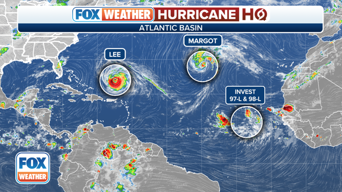
An overview of the tropical Atlantic Ocean on Tuesday, September 12, 2023.
(FOX Weather)
The top speed of the winds in Lee's circulation is forecast to continually drop as the storm moves north, but the size of the circulation is expected to dramatically grow in diameter. Don't be lulled by the lower numbers. Recall that Sandy had almost no hurricane-force winds in its circulation when it came ashore producing a massive storm surge.
We should get more forecast certainty once the storm starts its move to the north tomorrow. But there are things we know for sure today. Lee's increasingly large circulation will produce highly energized swells from Central Florida to Maine. Because of the direction of movement from south to north, the most intense energy will be focused north of Cape Hatteras, North Carolina through the Northeast and New England and into Atlantic Canada.