

Bryan Norcross: Keeping an eye on the Southwestern Gulf while Mexico watches for the next storm to develop
Hurricane Rachel has reached Category 3 strength, but it's heading out to sea. Its main effect will be to generate strong swells in the ocean that will arrive in Southern California next week.
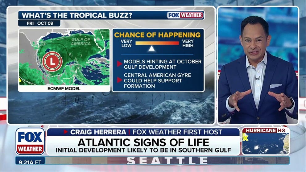
Long-range signals show the potential for tropical mischief in the Gulf in October
While the year without an Atlantic hurricane continues, forecasters are turning their attention to the Gulf, where historically many tropical systems develop in October. There are some long-range signals that the Central American Gyre (CAG) will form sometime later this month. The CAG is a sprawling area of low pressure near or over Central America that can produce locally heavy rain, rough surf and mudslides, and can generate tropical systems in both the Gulf and Eastern Pacific. However, while the ECMWF (European model) but more specifically the Google DeepMind models highlight potential development, the overall odds of development across the Gulf remain in the low category through October 10.
Last updated at 9 a.m. on Oct. 2, 2026
In the Gulf
Long-range computer forecast models show some possibility of a tropical depression or tropical storm eventually developing in the southwestern Gulf. A dip in the jet stream is forecast to push a cold front into the Gulf next week where it will settle and stall. Sometimes an orphaned front can be the trigger for a tropical system.
LATEST FROM FOX WEATHER HURRICANE SPECIALIST BRYAN NORCROSS
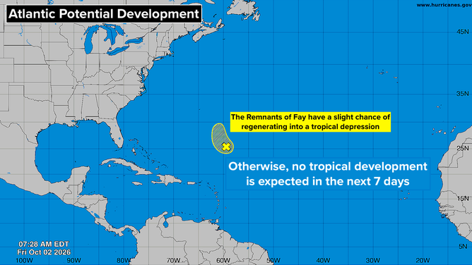
Atlantic Basin on Oct. 2, 2026.
(Bryan Norcross / FOX Weather)
The upper-level winds might let up enough after the front arrives to allow a low-pressure system to develop. We'll watch next week if that still seems like a possibility.
This fall, the broad non-tropical low-pressure system that spans from the Pacific to the Gulf to the Caribbean – the so-called Central American Gyre – has been pulled into the Pacific, such that it exists at all. That has, so far, eliminated one of the most common mechanisms that generates a Gulf or Caribbean tropical system.
If the Gyre remains out of the picture, as it is forecast to do for the next couple of weeks at least, a dying front or a stalled non-tropical disturbance will be the types of systems we'll watch for.
In the Atlantic
The remnants of Tropical Storm Fay are interacting with an upper-level low-pressure system, which is causing thunderstorms to flare up in the open ocean southeast of Bermuda.
The National Hurricane Center has very low odds on the possibility of Fay regenerating into even a tropical depression.
In the Pacific
Hurricane Rachel has reached Category 3 strength, but it's heading out to sea. Its main effect will be to generate strong swells in the ocean that will arrive in Southern California next week. Dangerous conditions can be expected in the surf, and some coastal flooding could be possible.
HURRICANE HQ&A: BRYAN NORCROSS SPEAKS TO GOOGLE DEEPMIND ENGINEER TOM ANDERSSON
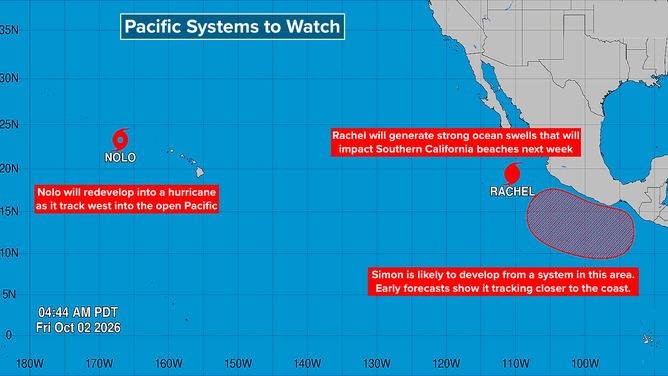
Pacific Basin on Oct. 2, 2026.
(Bryan Norcross)
An extreme heat wave will be impacting the Southwest including the Southland of California next week, so more people than normal will likely be at the beach. Caution will be required.
Behind Rachel, Tropical Storm and possibly Hurricane Simon looks likely to develop. It will track north along or near the west coast of Mexico. While Rachel and before that Polo quickly turned out to sea, long-range projections for Simon show it tracking closer to the Mexican coast. Stay informed in the potentially affected areas.