Bryan Norcross: Gulf disturbance, Invest 93L, to bring rain and wind to northern Gulf Coast
By Wednesday, the system, whether it fully organizes into a depression or not, is expected to merge with a front extending across the northern Gulf and become a potent non-tropical coastal storm near the Louisiana coast.

FOX Weather is your Hurricane HQ, streaming free 24/7.
(FOX Weather)
Updated at 9:30 a.m. EDT on Tuesday
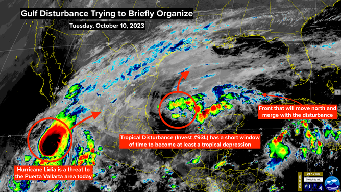
The tropical disturbance in the southern Gulf of Mexico – officially tagged Invest 93L – shows some slight signs of organization. The window of time for it to develop into a tropical depression is short, however. By tomorrow, the system, whether it fully organizes into a depression or not, is expected to merge with a front extending across the northern Gulf and become a potent non-tropical coastal storm near the Louisiana coast.
Meteorologically speaking, there is a thick gumbo of players in this weather scenario. First is the slowly developing low-pressure area in the Bay of Campeche – the far southern part of the Gulf of Mexico. It is drifting north under marginally conducive atmospheric conditions. The National Hurricane Center is giving it a low chance of becoming a depression before it merges with the frontal system across the northern Gulf tomorrow.
The front is currently draped across South Florida and has been responsible for the cool weather across the south, comfortable weather in Central Florida and persistent storminess across the southern peninsula.
A satellite image of the Gulf of Mexico and eastern tropical Pacific Ocean.
(NOAA)
The front will move north, intensify across the northern Gulf over the next couple of days, and become a focus for heavy rain.
In addition, moisture from Tropical Storm Max, which made landfall on Mexico’s Pacific coast north of Acapulco yesterday, will be absorbed into the Gulf low today. Meanwhile, moisture from much stronger Hurricane Lidia, which will make landfall today near Puerto Vallarta, far up the Pacific coast of Mexico, will stream across the northern Gulf coast, adding to the heavy-rain potential.
By tomorrow, these systems are expected to come together just south of Louisiana. Winds over the water are forecast to reach 40 mph, and a band of heavy rain will impact the coastal sections.
Most of the rain is expected to fall along and south of the Interstate 10 and Interstate 12 corridor in Louisiana but extend farther inland across the Southeast as the system migrates farther east late tomorrow and Thursday.
Rain is desperately needed along parts of the Gulf Coast, and this should help, although a local flood threat is possible if too much comes all at once. Stay aware of local alerts.
Even though the system might produce 40 mph (tropical-storm-force) winds, it would not be designated a tropical storm because it will be involved with fronts and drawing its energy from the contrast of the cool air to the north and the warm air over the Gulf. It will be a wintertime-like coastal low-pressure system.
An overview of the tropical Atlantic Ocean.
The system’s only opportunity for the tropical record book appears to be today before it reaches the northern Gulf.
Hurricane Lidia mentioned above is a serious threat to the Puerto Vallarta area on the Pacific coast of Mexico. The storm is forecast to be Category 2 when it makes landfall later today. The bay and beaches adjacent to the city are open to the west. If the hurricane comes ashore just north of there, a dangerous storm surge could impact vulnerable areas. Tell your friends there to stay informed.
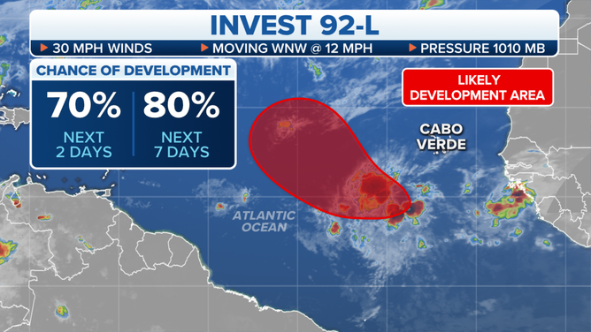
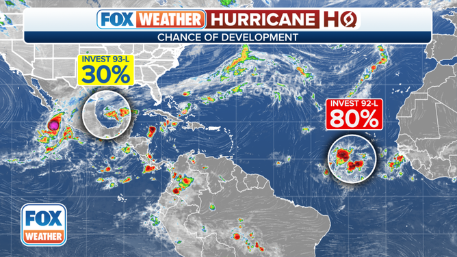
The chances of development for Invest 92L in the Atlantic Ocean.
On the far side of the Atlantic, the tropical disturbance officially called Invest 92L is still expected to organize into at least a tropical depression. The system is forecast to turn north into the open ocean and not be a threat to land.
Nothing else appears imminent across the tropics.