

Bryan Norcross: Last day for Edouard's rain in Texas while we watch Lowell and Hawaii for early next week
Everybody in Hawaii should stay informed about the latest forecast developments through the weekend.
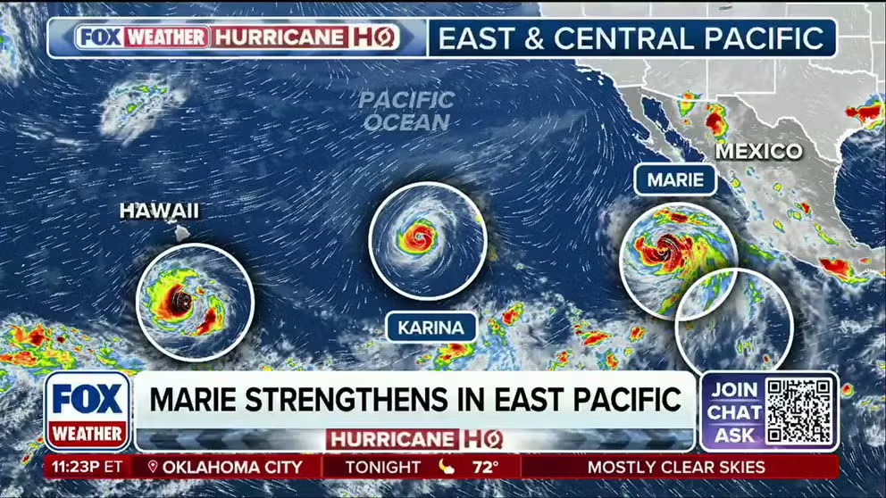
Marie strengthens into a hurricane as powerful storms spin nearby in busy Pacific
Marie has strengthened into a hurricane as tropical activity continues to crowd the Pacific, joining powerful Category 4 Hurricane Lowell while other systems could bring impacts to Hawaii by the weekend.
Updated at 9:15 A.M. ET on Thursday, September 3
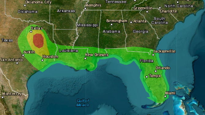
Former Tropical Storm Edouard has lost its circulation. But tropical moisture remains parked over Texas southeast of Dallas. The National Weather Service is painting a bull's-eye there for the possibility of continued excess rainfall causing flooding, especially in urban and low-lying areas. Be aware of any flood alerts issued by your local National Weather Service office.
The rain is forecast to taper off significantly by later today as the moisture spreads out across North and Central Texas.
The good side of Edouard was that it cooled things off. The clouds and lingering showers will provide a little shade. By the weekend, 90s to near 100-degree temperatures will return.
LATEST ON FORMER TROPICAL STORM EDOUARD'S IMPACTS IN TEXAS
Elsewhere in the Atlantic, there is no sign of development for the foreseeable future.
(FOX Weather)
Over Florida, however, some of ex-Dolly’s moisture will add to the very wet weather pattern. Some heavy thunderstorms are likely through the Labor Day weekend.
HURRICANE LOWELL AND HAWAII
Long-range forecasts mostly show the core of Hurricane Lowell passing west of the main Hawaiian Islands late Monday into Tuesday, but they also show high uncertainty in the track. The consensus of the forecasts is that Kauai and Oahu will feel impacts from Lowell's outer bands, but not the worst of the storm. The possibility, however, of a direct hit on Kauai is not completely off the table.
The European computer forecast model has shifted its track annoyingly close to Kauai, but these days we don't just look at one model. We get the spread of plausible possibilities from multiple models, both traditional and AI-based. And each model family generates a reasonable set of possibilities giving us an understanding of the uncertainty intrinsic in the storm's atmospheric environment.
In this case, the message is that there is higher-than-normal uncertainty on exactly where Hurricane Lowell will track as it passes the islands. In other words, how far offshore of Kauai and the far western island, Niihau, will it be?
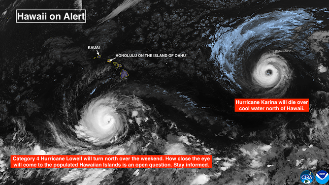
Satellite imagery depicts the latest location of Hurricane Lowell in the Pacific
(FOX Weather)
Hurricane Lowell is down to Category 4 strength today well south of Hawaii. The mostly westward track is forecast to continue through tomorrow. Then on Saturday, the consensus of the computer forecast models and the official National Hurricane Center forecast is for Lowell to make a hard right turn to the north.
LATEST UPDATES ON HURRICANE LOWELL
It is already quite windy today across Hawaii because the islands are caught between high pressure to the north and the extreme low pressure of super-strong Hurricane Lowell over 400 miles to the south. Winds today could gust to tropical storm strength, especially near and over the mountains and passes.
The winds should decrease some tomorrow and be dramatically lower over the weekend. Another storm, Hurricane Karina, will track north of Hawaii and weaken the high-pressure system.
On the current schedule, moisture pulled north by Hurricane Lowell will reach the Big Island on Sunday. Lowell will be a long way from the state, but the general flow out of the south will pull tropical moisture toward the islands far from the center of the hurricane.
As Lowell moves north over the weekend, moisture will increase across the islands by Monday, peaking on Oahu and Kauai late Monday or Tuesday. Southerly winds will increase at the same time. The strength of the winds will, obviously, depend on how far away the center of Lowell ends up tracking.
A sharp dip in the jet stream north of the state is forecast to sink south and provide the steering to bring Lowell to the north. The exact geometry of that flow is uncertain, which gives us the range of possible impacts. The range of plausible tracks says that it's not likely, but it's also not impossible, that Lowell will track close to Kauai. By far the majority of the forecast scenarios currently show it far enough west that the populated islands would not take a direct hit, but it's too early to know for sure.
Related to the questions about the orientation of the jet stream dip, an important rule will come into play. Forecasts for just developing, disorganized, or slow-moving storms are subject to larger-than-normal errors. In this case, Hurricane Lowell will certainly be well developed, but it will slow down significantly as it makes its turn to the north. Therefore, uncertainty is added to the storm's forecast track as it passes the islands.
Tropical impacts are magnified by the mountains, as we saw with Hurricane Lala on Hawaii Island and the windward end of Maui. In this case, the windward side of Oahu and Kauai will likely be the south side, which will be unusual. So we have to be ready for atypical stream flows.
Everybody in Hawaii should stay informed about the latest forecast developments through the weekend.
OTHERWISE IN THE PACIFIC
Hurricane Karina has peaked and is now in the weakening stage. It will track well north of Hawaii. Its remnants may well eventually get absorbed by Lowell.
Offshore of Mexico, Marie is nearing hurricane strength. It will stay offshore, but some moisture may be pulled out of the storm and spread across the desert Southwest over the weekend. Stay aware if outdoor activities are in your Labor Day weekend plans in that part of the country.
Yet another storm is forecast to form and follow Marie's track offshore.