Disruptive snow falls in Eastern Massachusetts and Boston as extreme cold grips the Northeast
Over a foot of snow fell just north of Boston in Hamilton and Salisbury, Massachusetts, as wind gusts cause feel-like temperatures to drop below zero.

Winter weather alerts in effect across New England as clipper delivers heavy snow to Boston
A clipper system is bringing snow to New England, with. Boston and the North Shores of Massachusetts expecting at least 3-5 inches of snow through this evening. In addition to the snow, strong gusty winds will be a problem combined with the arctic air leaving temperatures feeling like below zero by Sunday morning.
BOSTON, Mass. – More than a foot of snow has already fallen in parts of eastern Massachusetts as a fast-moving clipper system pushes another round of extreme frigid temperatures into the Northeast.
This sweeping system ushered in light to moderate snow showers and strong gusty winds.

A pedestrian passes snow-covered vehicles following a winter storm in Boston, Massachusetts, US, on Monday, Jan. 26, 2026.
(Mel Musto/Bloomberg / Getty Images)
Much of southern New England was under Winter Weather alerts through early Sunday. A Winter Storm Watch was also in place for the North Shore of Massachusetts, just north of Boston.
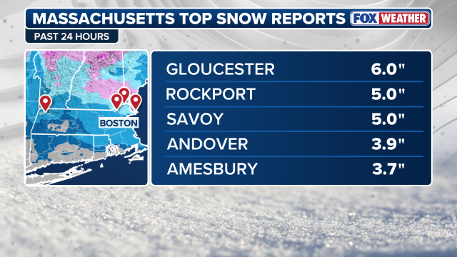
Eastern Massachusetts was right in the bullseye for impacts of the storm, with at least 3 inches of snow expected for parts of the state. Just north of Boston, towns received over a foot of snow.
WINTER STORM WARNING EXPLAINED: WHAT DOES IT MEAN AND WHEN IS IT ISSUED?
Both Hamilton and Salisbury, MA, received 13 inches of snow, according to the FOX Forecast Center.
(FOX Weather)
Some locations, particularly around the North Shore region of Massachusetts and into coastal New Hampshire, saw up to 10 inches of snow.
Most other areas of the Northeast and New England saw 1 to 3 inches of snow over the weekend.

Snowstorm slams Massachusetts as extreme cold temperatures hit the Northeast
Another weekend snowstorm is slamming Massachusetts with some areas expected to receive up to 8 inches of snow. FOX Weather Correspondent Brandy Campbell is in Boston, Massachusetts covering this storm and the extreme cold temperatures impacting the region.
Saturday's snow fell on top of previous snow from the Jan. 25 snowstorm, which buried Boston in 23.3 inches of accumulation.
HISTORIC WINTER STORM KILLS OVER 80, IMPACTS MILLIONS ACROSS MORE THAN 40 STATES
![BOSTON, MA - January 26: Snow banks in front of Boston City Hall on January 26, 2026.]() Image 1 of 5
Image 1 of 5BOSTON, MA - January 26: Snow banks in front of Boston City Hall on January 26, 2026. (David L. Ryan/The Boston Globe )
![A resident clears snow surrounding a vehicle in Somerville, Massachusetts, US, on Monday, Jan. 26, 2026.]() Image 2 of 5
Image 2 of 5A resident clears snow surrounding a vehicle in Somerville, Massachusetts, US, on Monday, Jan. 26, 2026. (Mel Musto/Bloomberg)
![BOSTON, MASSACHUSETTS - JANUARY 26: A person clears a driveway with a snowblower following a major storm on January 26, 2026 in Boston, Massachusetts]() Image 3 of 5
Image 3 of 5BOSTON, MASSACHUSETTS - JANUARY 26: A person clears a driveway with a snowblower following a major storm on January 26, 2026 in Boston, Massachusetts. (Scott Eisen)
![BOSTON, MASSACHUSETTS - JANUARY 25: People walk on the frozen Frog Pond in the Boston Public Garden during heavy snow on January 25, 2026 in Boston, Massachusetts.]() Image 4 of 5
Image 4 of 5BOSTON, MASSACHUSETTS - JANUARY 25: People walk on the frozen Frog Pond in the Boston Public Garden during heavy snow on January 25, 2026 in Boston (Scott Eisen/)
![BOSTON, MA - January 29: Commuters board an MBTA bus on January 29, 2026, climbing over snow piled along the curb after storms earlier in the week dumped heavy snowfall across the region.]() Image 5 of 5
Image 5 of 5BOSTON, MA - January 29: Commuters board an MBTA bus on January 29, 2026, climbing over snow piled along the curb after storms earlier in the week dumped heavy snowfall across the region. (Erin Clark/The Boston Globe)


Before the sun even rose on Saturday, light snow was already pushing into Massachusetts and Maine.
As the morning progressed, a band of heavier snow developed along the front itself as it moved across Vermont, Connecticut, Massachusetts, New Hampshire and Rhode Island.

(FOX Weather)
AIRPORT GROUND STOPS VS. GROUND DELAYS: WHAT ARE THEY AND HOW DO THEY HAPPEN?
Snow wrapped up by 6 p.m. as the arctic front pushed bands of snow back over the ocean. At that point, the winds became the more serious concern.
(FOX Weather)
Gusts in excess of 40 mph were noted Saturday night, causing areas of blowing snow which temporarily reduced visibility and led to dangerous driving conditions.
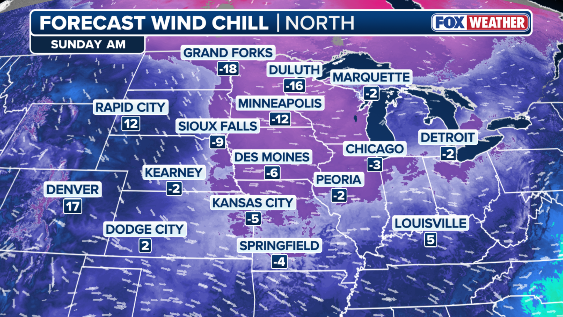
Combined with the arctic temperatures gripping the region, wind chills remain below zero in many areas.
By the time the sun rose on Sunday, temperatures felt as low as -25 degrees, according to the FOX Forecast Center.
(FOX Weather)
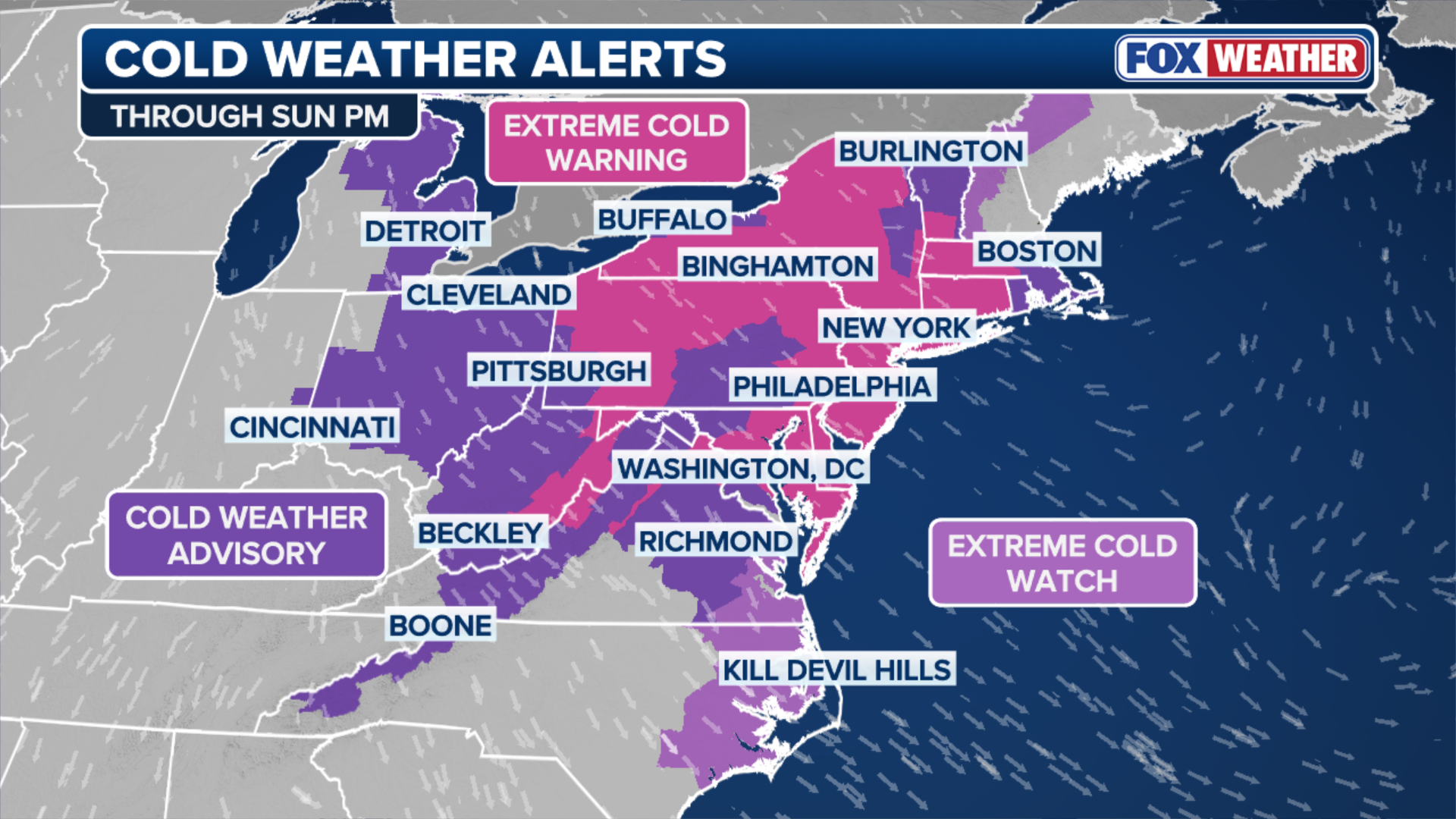
Cold Weather Alerts have been issued for millions from the Outer Banks into far-reaching Maine through Sunday evening.
The most severe cold weather alert, Extreme Cold Warnings, have been issued for over 43 million Americans, including in New York City, Philadelphia and the entire state of Connecticut.
2 DEAD AFTER AVALANCHE NEAR SITE OF WINTER OLYMPICS IN ITALIAN ALPS
Temperatures are expected to return to near average by mid next week.