Back-to-back storms slam West Coast, bringing heavy rain, extended flash flood threat
Rain stretches from northern California into Oregon, with snow throughout higher elevations in the Sierra Nevada mountains. Flooding is possible up and down the California coast through the weekend.

Torrential rain inundates parts of California, causing highway closures as Flash Flood threats and alerts persist amid powerful back-to-back storm
Flash Flood threats and alerts remain in effect for portions of California, as torrential rain inundated parts of the region yesterday, causing two major highway closures. More rain is expected today, with snow for higher elevations.
The West Coast from California up into the Pacific Northwest is seeing an active weather pattern filled with back-to-back storms to start off the year.
Rain continues to stretch from northern California into Oregon, with snow throughout higher elevations in the Sierra Nevada mountains.
Flooding is possible up and down the California coast through the weekend, as Saturday's torrential rain caused two major highway closures and a regional airport closure.
The severe conditions also led to the death of a man who was swept away during flooding this weekend, according to the Santa Barbara County Sheriff's Office.
MAN DIES IN CALIFORNIA AFTER BEING SWEPT AWAY INTO CREEK DURING FLOODING, TORRENTIAL RAIN
Family members contacted police, reporting that a man had been swept into Maria Ygnacio Creek. Around 1:50 p.m., crews located him deceased near the intersection of San Marcos Road and Via Parva.
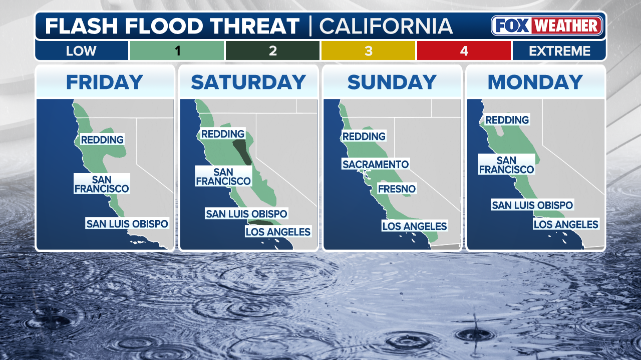
The heaviest rain began late Friday morning. A level 1 out of 4 Flash Flood Threat remains until Monday all up the California coastline.
A level 2 out of 4 flash flood risk existed for pockets of northern and southern California on Saturday, particularly up in the mountains and down around Los Angeles and the risk remains for northern California today.
(FOX Weather)
More rain will come through Sunday, with the heaviest rain for central and southern California.
The National Weather Service office for the Bay Area issued a Coastal Flood Advisory for the San Francisco Bay through the afternoon Sunday due to the combination of King Tides and storm surge.
The NWS said 2.5 feet of inundation is expected, which hasn't been recorded since 1998.
YEAR IN REVIEW: SHOCKING SATELLITE IMAGES OF EXTREME WEATHER SEEN FROM SPACE

(FOX Weather)
Strong, gusty winds will also be a concern, with wind alerts issued for most of the California coast, excluding southern California.
The FOX Forecast Center said gusts could reach 70 mph for the northern California coast.
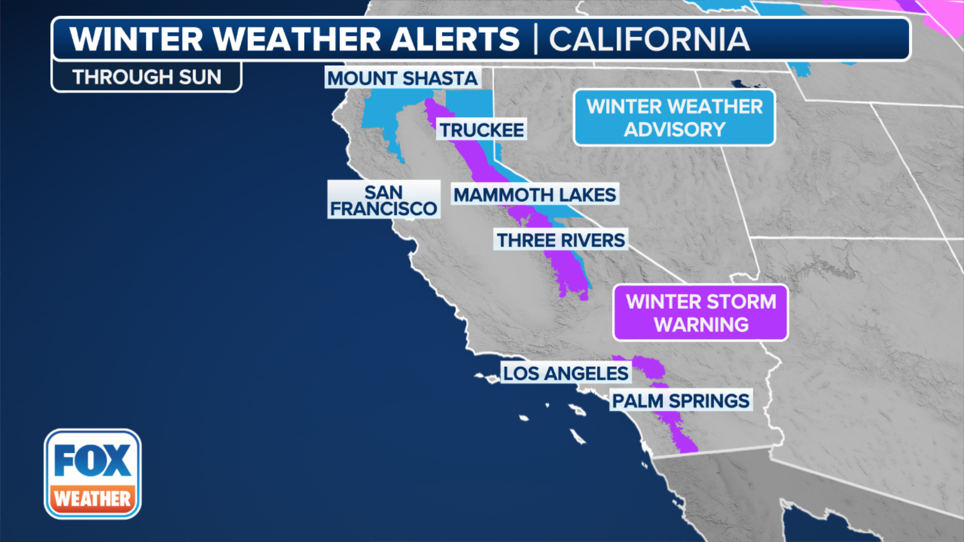
Snow in the mountains above 5,000 feet elevation could total 2 to 4 feet, with higher snow totals possible at higher elevations, according to the FOX Forecast Center.
A Winter Storm Warning is in effect for the Sierra Nevada mountains until Monday.
WINTER TRAVEL CAR KIT: CHECKLIST OF EMERGENCY ESSENTIALS TO KEEP IN YOUR CAR IN CASE YOU GET STUCK
(FOX Weather)
Gusty winds combined with the snow can lead to extremely dangerous travel conditions in the mountains.
Use caution when traveling and be prepared for difficult driving conditions.
A few thunderstorms are also possible Sunday morning in northern California and into Oregon.
This comes after rounds of flooding rain slammed southern California on New Year's Day.
KNOW YOUR FLOOD TERMINOLOGY: WHAT FLOOD WATCHES, WARNINGS AND EMERGENCIES REALLY MEAN
![San Diego, CA - January 1: Vehicles parked on Camino De La Reina in Mission Valley were submerged after the San Diego River overflowed and flooded the area during a storm on January 1, 2026 in San Diego, CA.]() Image 1 of 4
Image 1 of 4San Diego, CA - January 1: Vehicles parked on Camino De La Reina in Mission Valley were submerged after the San Diego River overflowed and flooded the area during a storm on January 1, 2026 in San Diego, CA. (K.C. Alfred / The San Diego Union-Tribune)
![San Diego, CA - January 1: A San Diego Police officer, standing on State Route 163, and members of the San Diego Lifeguard River Rescue Team look for people after the San Diego River overflowed and flooded areas in Mission Valley during a storm on January 1, 2026 in San Diego, CA.]() Image 2 of 4
Image 2 of 4San Diego, CA - January 1: A San Diego Police officer, standing on State Route 163, and members of the San Diego Lifeguard River Rescue Team look for people after the San Diego River overflowed and flooded areas in Mission Valley during a storm on January 1, 2026 in San Diego, CA. Several people were rescued throughout the day. ( K.C. Alfred / The San Diego Union-Tribune )
![San Diego, CA - January 1: An adult and a child were rescued from a Jeep on Fashion Valley Road by the San Diego Lifeguard River Rescue Team after San Diego River overflowed and flooded areas in Mission Valley during a storm on January 1, 2026 in San Diego, CA.]() Image 3 of 4
Image 3 of 4San Diego, CA - January 1: An adult and a child were rescued from a Jeep on Fashion Valley Road by the San Diego Lifeguard River Rescue Team after San Diego River overflowed and flooded areas in Mission Valley during a storm on January 1, 2026 in San Diego, CA. (K.C. Alfred / The San Diego Union-Tribune )
![San Diego, CA - January 1: A traffic sign is submerged on Camino De La Reina in Mission Valley which flooded after the San Diego River overflowed during a storm on January 1, 2026 in San Diego, CA.]() Image 4 of 4
Image 4 of 4San Diego, CA - January 1: A traffic sign is submerged on Camino De La Reina in Mission Valley which flooded after the San Diego River overflowed during a storm on January 1, 2026 in San Diego, CA. ( K.C. Alfred / The San Diego Union-Tribune )


Video from Palm Springs showed flooded streets as a car drove through the rain.
Cars were reported stuck in floodwaters across San Diego, with multiple water rescues as the San Diego River flooded.

Watch: Car drives through street flooding in Palm Springs during heavy rain on New Year's Day
Southern California saw a rainy start to 2026, with street flooding being reported across the region from heavy rain. The state is getting slammed with back-to-back storms bringing the possibility of more flash flooding.
7 FACTS YOU SHOULD KNOW ABOUT FLASH FLOODS
As we look ahead to the middle of next week, the active pattern may persist.
Additional moisture, more rain at lower elevations, continued mountain snow and breezy conditions remain possible, keeping the region locked into an extended stretch of unsettled weather.