Atlantic Ocean’s record warmth finally breaks as Saharan dust settles in over basin
NOAA says more than 180 million tons of dust leave the African continent annually, and the extent of the dust plume is highly dependent on how much rain falls across northern Africa.

Atlantic hurricane season begins in 1 month
The Atlantic hurricane season begins on June 1 and runs through Nov. 30. FOX Weather Hurricane Specialist Bryan Norcross discusses the factors forecasters are analyzing that could lead to a hyperactive 2024 hurricane season.
Just in time for the Atlantic hurricane season, water temperatures in large parts of the basin are cooling, but forecasters warn that it won't take much to reverse the trend.
According to satellite estimates, the Atlantic basin entered record territory on March 5, 2023, and ended the streak around the last days of April – a preliminary record of 421 days.
This caused recent springtime temperature readings to resemble observations that are typically prevalent during summer months, a trend that weather watchers and some forecasters warned was an ominous sight ahead of the hurricane season.
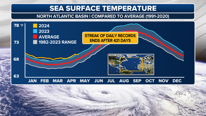
North Atlantic sea surface temperatures
(FOX Weather)
Tropical cyclones generally require water temperatures of around 80 degrees to undergo significant organization, a threshold that large parts of the Gulf of Mexico, Caribbean and Main Development Region of the Atlantic Ocean have already exceeded.
Features such as Saharan dust and an increase in trade winds can help to cool waters, as has been the case over the Atlantic in recent weeks.
Significant plumes of dust and dry air are common in the Atlantic during the first two and a half months of the hurricane season.
Despite the cooling of water temperatures, the basin is still around a degree Celsius warmer than usual for early May, with the warmest months of the year still ahead.
Water temperatures in the tropics usually peak in early September and coincide with the heart of hurricane season activity.
![Saharan air layer map from 5/4/2024]() Image 1 of 2
Image 1 of 2Saharan air layer map from 5/4/2024 (University of Wisconsin-Madison)
![Saharan dust cover tracker showing an uptick in activity as waters cool]() Image 2 of 2
Image 2 of 2Saharan dust cover tracker showing an uptick in activity as waters cool ( )


A LOOK AT A PHENOMENON THAT COULD DERAIL AN ACTIVE HURRICANE SEASON
The warm water was one of the focuses of recent hurricane outlooks that called for a busy season in the Atlantic.
Research scientists at Colorado State University are expecting 23 named storms to form, with 11 that could reach hurricane status. Nearly half of all hurricanes could become major cyclones with winds of at least 115 mph.
Forecasters took into consideration computer model outputs that show a continued warm basin, coupled with less wind shear and other favorable ingredients.
These conditions are tell-tale signs that a La Niña could be on the way, which often leads to enhanced cyclogenesis in the Atlantic.
Warm water alone does not guarantee increased tropical cyclone activity.
Take August 2022, for example. Water temperatures resembled a bathtub, and a La Niña controlled weather patterns.
Typically, August is the second-busiest period in the entire season, but zero named tropical cyclones formed during the late summer of 2022. A reanalysis found that dry air, high pressure, and shear prevented cyclones from developing.
More recently, the western Pacific has produced zero cyclones despite warm water, setting the basin up for its slowest start to the typhoon season since 2016.
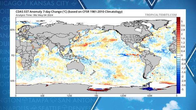
Water temperature change over the last 7 days.
(Tropicaltidbits.com / FOX Weather)
5 THINGS TO KNOW ABOUT THE SAHARAN DUST PLUME
Besides warm water being an ingredient for hurricanes, NOAA warns that it can also lead to coral bleaching, melting of ice sheets and changes to vital ecosystems.
In 2023, the agency estimated that less than 22% of approximately 1,500 staghorn corals around the state of Florida survived due to record warm water.
Just a 2-degree change in temperature can cause coral to lose the beneficial algae and lead to bleaching.