

Invest 92L designated in the Atlantic as tropical activity ramps up in the main development region
One of these disturbances could become the Atlantic’s next tropical system.
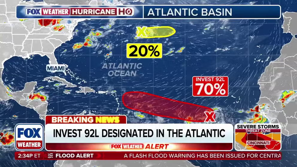
Invest 92L designated as Atlantic tropical activity heats up
The Atlantic’s main development region is beginning to come to life. The National Hurricane Center has designated the main disturbance in the tropical Atlantic as Invest 92L, which now has a 70% chance of development over the next 7 days. FOX Weather Meteorologist Bayne Froney breaks down the latest developments and what Invest 92L could mean for the Atlantic hurricane season.
The National Hurricane Center (NHC) is monitoring two areas in the Atlantic for potential tropical development in what has been a quiet start to the 2026 hurricane season, particularly across the Atlantic's Main Development Region (MDR) — the area between Africa and the Caribbean where many hurricanes begin to form.
The NHC designated the main disturbance in the Atlantic as Invest 92L on Tuesday, with a 70% chance of development in the next seven days, with a chance that a tropical depression forms over the weekend.
LATEST FROM FOX WEATHER HURRICANE SPECIALIST BRYAN NORCROSS
The term "invest" is used every hurricane season in the Atlantic and the Eastern and Central Pacific basins, accompanied by a number from 90 to 99 and either the suffix "L," "E" or "C," respectively.
 Invest 92L.
(FOX Weather)
Right now, numerous tropical waves, disturbances that can produce showers and thunderstorms, are moving off the coast of Africa into the MDR, which could fuel the Atlantic basin's next named storm.
The NHC is now giving a group of thunderstorms loosely associated with an area of low pressure, designated as Invest 92L, about 500 miles southwest of the Cabo Verde Islands a high chance of development over the next seven days.
WHAT'S THE DIFFERENCE BETWEEN A TROPICAL DEPRESSION, TROPICAL STORM AND A HURRICANE?
The system is about a third of the way from Africa to the Caribbean and is showing some signs of organization, with the NHC having the odds in the high range that it will develop into at least a tropical depression somewhere in the red potential development area.
For the next few days, Invest 92L will track in the general direction of the northeast Caribbean, though it's uncertain where and when the window of development opportunity might open.
 Areas to watch in the Atlantic.
(FOX Weather)
The FOX Forecast Center said this disturbance will have a favorable environment for development in the short term as it moves westward.
Meanwhile, a tropical wave that is expected to move off Africa within the next day could merge with this system or remain a separate disturbance.
Separately, Invest 93L has been designated in an area several hundred miles east of the Lesser Antilles, though it has a low chance of tropical development.
WHAT IS AN INVEST DURING HURRICANE SEASON?
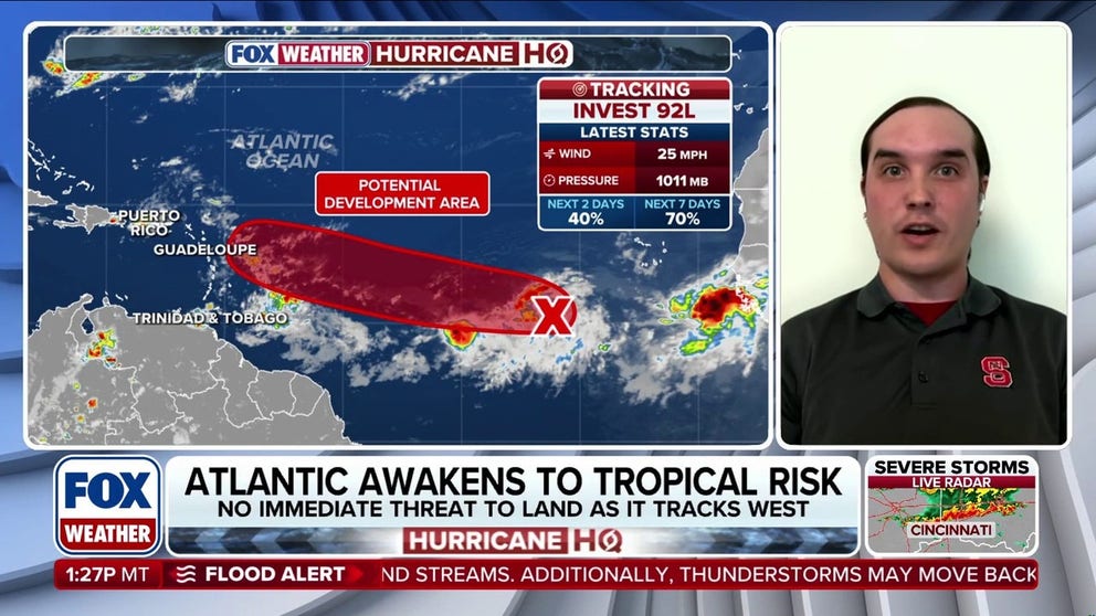
Tropical trouble spins up in the Atlantic and Pacific basins
Research Scientist at the North Carolina Institute for Climate Studies John Uehling, Ph.D., joins FOX Weather to discuss the latest in the tropics. Both Invest 92L and 93L have been designated in the Atlantic basins as tropical activity ramps up.
According to the FOX Forecast Center, the reason it was designated an invest was because on satellite, it shows an area of low level spin, which was enough to warrant further investigation by the NHC.
While the disturbance currently poses no major threat, it could eventually bring some beneficial rainfall to drought-stricken portions of the Caribbean, where an intensifying El Niño is expected to worsen dry conditions in the coming months.
 Saharan Dust Tracker.
(FOX Weather)
As Invest 93L moves towards cooler waters closer to Bermuda in the Subtropical Atlantic, the FOX Forecast Center said this disturbance has a low chance of developing.
The National Oceanic and Atmospheric Administration (NOAA) recently issued their updated 2026 Atlantic hurricane outlook, where they stated they estimate seven to 13 named storms to form this season, two to six hurricanes, including up to two reaching Category 3 strength or higher.
Those ranges include Tropical Storms Arthur and Bertha, which formed in the Gulf earlier this summer.
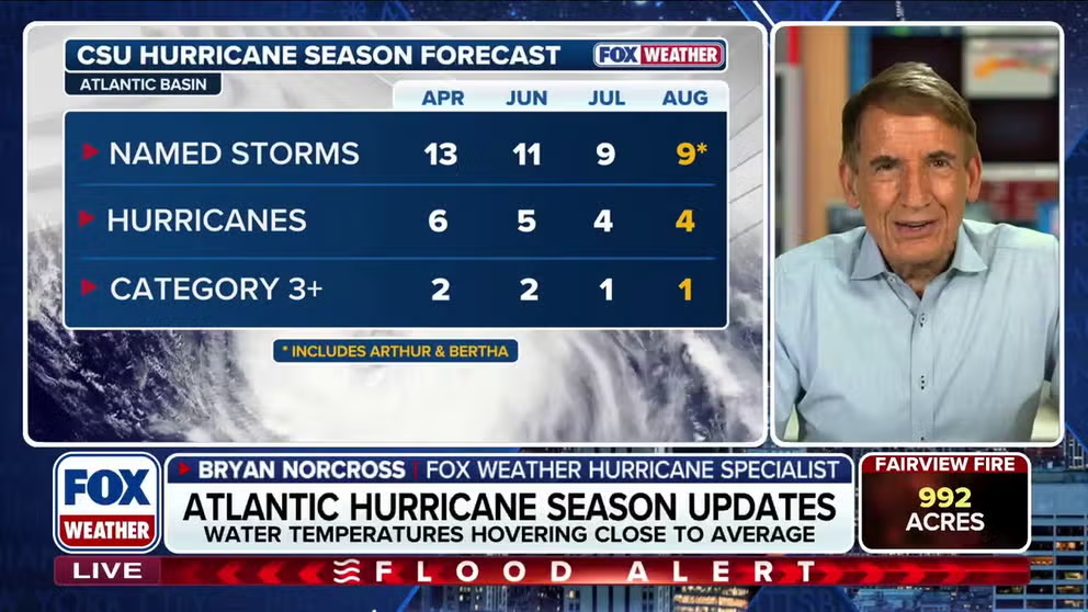
Hurricane season update: Bryan Norcross on 2 named storms and El Niño
HURRICANE HQ 🌀: FOX Weather Hurricane Specialist Bryan Norcross shares an update on the progress of hurricane season, as experts monitor a strengthening El Niño this week. There have been two named storms so far this season. #Hurricane #Severewx #FOXWeather
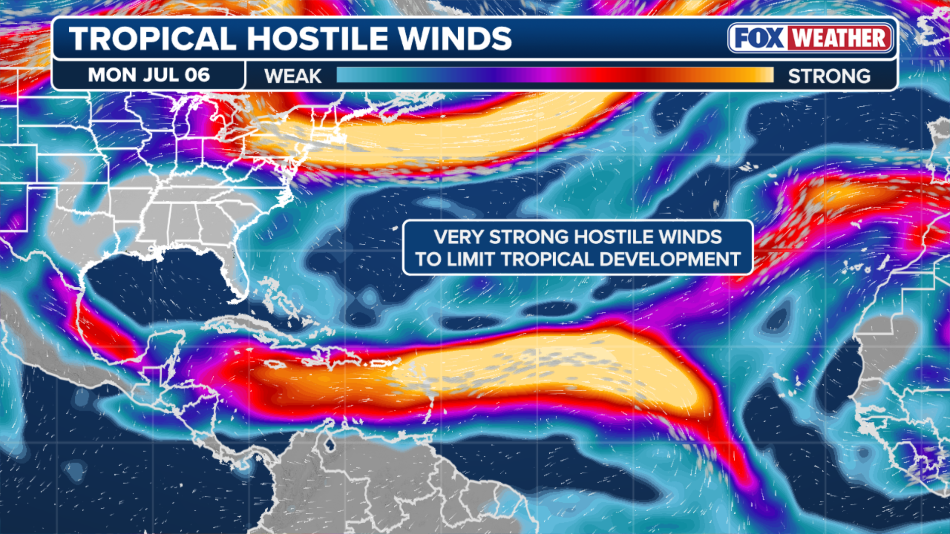
Government forecasters said they expect a very strong El Niño climate pattern to last through this fall, creating atmospheric conditions that will suppress tropical development in the Atlantic Ocean.
El Niño, one of three phases of a climate cycle called the El Niño-Southern Oscillation (ENSO), describes natural temperature changes in the central Pacific Ocean that alter atmospheric circulation and can greatly influence global weather.

Windy day at the beach.
(BlueFolio / Getty Images)
During El Niño, above-average water temperatures in the central and eastern Pacific Ocean alter the position and strength of the subtropical jet stream. It's typically more robust and extends well into the Caribbean and Atlantic Ocean.
The jet stream is a belt of very fast winds high in the atmosphere.
Stick with FOX Weather as this story continues to develop.