Rounds of severe weather, snow expected to kick off the work week
Storms will kick off on Monday afternoon
Multi-day severe thunderstorm outbreak appears increasingly likely starting Monday
A multi-day severe thunderstorm outbreak appears increasingly likely for parts of the Southern Plains toward the lower to mid-Mississippi Valley early to mid-week. The coverage and severity of storms will likely increase Tuesday and Wednesday as a more potent upper-air disturbance moves into the region.
A classic springtime weather pattern will spawn not only another severe weather outbreak in parts of the Plains and South, but it will also produce snow for the Rockies, High Plains and Northern Plains.
That pattern will involve the upper-level jet stream taking a sharp, southward dip across the western and southwestern U.S., with areas of low pressure developing at the surface over the nation's midsection.

The result of this setup will be a sprawling spring storm system with severe thunderstorms on its warm side and heavy snow on its cold side, with these impacts beginning Monday and persisting into Thursday.
HOW TO WATCH FOX WEATHER ON TV
Severe storm potential
Monday
Another multiday severe weather event kicks off on Monday afternoon, with the risk of severe storms extending from the Southern Plains through the mid-Mississippi Valley.
There is also a possibility for severe storms to fire near the dryline in North Texas.
Some thunderstorms might be ongoing Monday morning over parts of Missouri, which could limit the northward extent of the moisture needed for storms to develop later in the day, so a widespread outbreak is not anticipated.
However, there should be enough instability available for at least isolated severe thunderstorms Monday afternoon and evening in northern and central parts of Texas, the eastern half of Oklahoma, southeastern Kansas, western and northern Arkansas, and southwestern and central Missouri.
Damaging wind gusts, large hail and some tornadoes are all potential threats on Monday.
WE'RE ENTERING AMERICA'S MOST ACTIVE TIME OF YEAR FOR TORNADOES

(FOX Weather)
Tuesday
The severe weather threat is expected to increase in coverage on Tuesday as more energy from that powerful jet stream is ejected into the central U.S.
Severe storms will likely develop by Tuesday afternoon from the Southern and Central Plains into the lower and mid-Mississippi Valley.
These thunderstorms will be capable of producing damaging wind gusts, large hail and tornadoes through Tuesday evening before the threat gradually diminishes overnight.
HERE'S WHERE TORNADOES ARE MOST LIKELY TO OCCUR IN EACH MONTH

(FOX Weather)
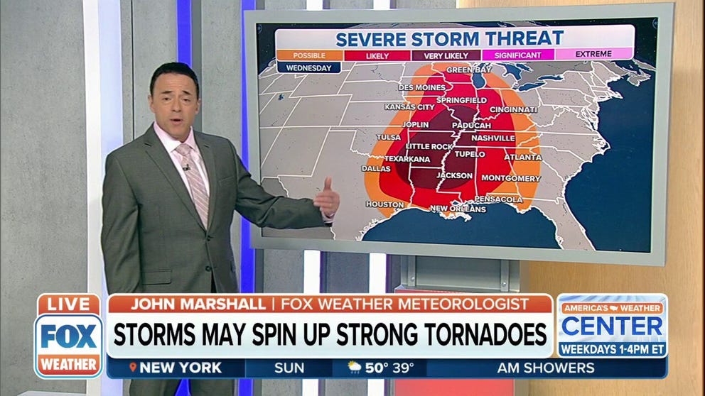
Wednesday
As the strong jet stream lumbers eastward across the Plains, Wednesday will likely provide the largest extent of severe weather from the Southern and Central Plains into the lower and mid-Mississippi Valley and parts of the mid-South.
Some of the areas in the threat zone have already seen several rounds of significant storms over the last few weeks.
Conditions appear favorable for the development of supercells, which could spawn tornadoes, large hail and damaging wind gusts.
An organized severe thunderstorm threat might continue into Wednesday night, including the potential for more tornadoes, across the lower Mississippi Valley and mid-South regions.
WHAT YOU SHOULD DO TO PREPARE FOR TORNADOES

(FOX Weather)
Some severe storms could linger into Thursday in portions of the central Gulf Coast and Southeast, but the exact areas at risk remain uncertain since it's still several days away.
Computer forecast models show this storm system will finally exit off the East Coast by Good Friday, but not before triggering what may become the fourth severe weather outbreak in four weeks. The National Weather Service has tallied more than 1,000 reports of severe weather since the first outbreak began on March 21.
Snowstorm potential
On the northern side of this powerful system, a late-season snowstorm will blanket parts of the Rockies, High Plains and Northern Plains.
While it's too early to predict exact snowfall amounts, the heaviest snow is expected to fall in portions of Wyoming, Montana, western Nebraska, the Dakotas and northern Minnesota. Many of these areas could pick up at least 6 inches of heavy, wet snow.

(FOX Weather)
Snow might begin as early as Sunday night or Monday in the Rockies, with the snowstorm then peaking between Tuesday and Thursday in the High Plains and Northern Plains.
In some areas, high winds could overlap with the snow and result in whiteout conditions, making it extremely dangerous for motorists attempting to drive during the storm.
While it is not unusual to get snow in April in these areas, it is getting late in the season for such a widespread event. Be prepared for travel disruptions in this region at the height of next week's snowstorm.
WHEN CAN YOU EXPECT THE LAST SNOW OF THE SEASON?
Check back with FOX Weather for updates as we fine-tune the forecast for both the severe weather and winter weather threats in the days ahead. Be sure to download the FOX Weather app for the latest forecast and weather alerts for your exact location, plus the 24/7 livestream of America's Weather Team.