April to kick off with strong severe weather threat for much of America's heartland
Communities such as Oklahoma City, Tulsa, and Norman in Oklahoma, as well as Springfield and Columbia in Missouri are in Monday’s threat zone. On Tuesday, the heightened risk zone shifts eastward and includes locations such as Nashville, Tennessee, and Louisville, Kentucky.
April to kick off with severe weather threat for much of US
Another classic spring storm is expected to impact the entire country from coast-to-coast throughout the next week.
An Easter holiday storm system that brought Flash Flood Warnings to Los Angeles and heavy rain and mountain snow to much of the rest of California is setting its eyes on the nation's heartland to begin the first week of April as it develops an area of low pressure in the central Plains on Monday.
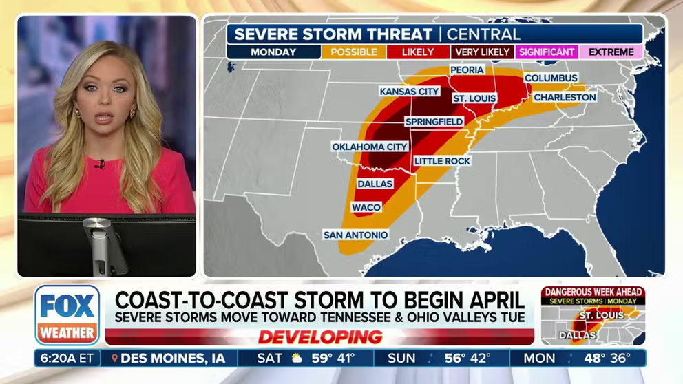
Forecast models show the first widespread severe weather event will be centered over the middle of the U.S. on Monday before sliding eastward and impacting areas such as the Tennessee and Ohio valleys on Tuesday. Thunderstorms could contain damaging wind gusts, frequent lightning and tornadoes.
"What starts in the West must eventually come East," FOX Weather Meteorologist Jane Minar said. "All of that energy, as it shifts through the weekend over the Four Corners, gets a second life as it develops over the central U.S."

(FOX Weather)
Monday forecast: Large section of country faces severe weather risk
Nearly 50 million Americans are included in the severe weather risk zone on Monday.
This comes as an influx of moisture from the Gulf of Mexico and a favorable atmosphere are expected to contribute to the widespread severe threat through the evening hours for parts of the Southern Plains northeastward into the mid-Mississippi Valley.
All hazards, including large hail, wind damage and tornadoes will be possible. The severe threat is expected to impact parts of the Ohio Valley Monday night.
Communities such as Oklahoma City, Tulsa, and Norman in Oklahoma, as well as Springfield and Columbia in Missouri, are facing a Level 3 out of 5 threat for severe weather, NOAA's Storm Prediction Center said.
THE 5-POINT SEVERE THUNDERSTORM RISK CATEGORY SCALE EXPLAINED
With the more dominant supercells in central and eastern Oklahoma, there is a possibility of hailstones exceeding 2 inches in diameter, the SPC said.

(FOX Weather)
The severe weather threat is expected to continue well after sunset Monday, meaning that some tornadoes could be nocturnal. Nighttime tornadoes are more than twice as likely to result in fatalities than those that happen during the day.
NIGHTTIME TORNADOES FAR MORE LIKELY TO TURN DEADLY THAN DAYTIME ONES
On the northern side of the storm system, snow and freezing rain are potential threats from the north-central Plains on Sunday, stretching into the Upper Midwest and Great Lakes region Monday, according to the FOX Forecast Center.
Tuesday forecast: Severe storms work east
Lingering showers and thunderstorms from Monday and the redevelopment of cells over the Tennessee and Ohio Valleys are expected to be the main themes Tuesday.
Tuesday’s heightened threat zone stretches from Ohio into northern Mississippi and Alabama.
The zone includes communities such as Nashville, Tennessee, and Louisville, Kentucky.
Like Monday, the FOX Forecast Center has warned that all modes of severe weather will be possible. The geographic scope should be reduced compared to Monday’s threat zone.

(FOX Weather)
"The key messaging here is that as we follow what happens with the rain over the weekend in the West, don’t lose sight of the start of the new week, the start of the new month," Minar said. "Come April, make sure you have your FOX Weather app downloaded, and those alerts turned on."
Beyond Tuesday, predictability is too low to categorize any one community as being in a heightened threat.
Showers and thunderstorms will continue to erupt until the frontal boundary exists on the East Coast by Thursday.
April typically sees an increase in severe weather outbreaks as seasonal air masses clash over the eastern half of the country. In fact, the month is usually the second busiest for tornadoes, only outdone by May.
More active severe weather events in April typically happen when the El Niño-Southern Oscillation is in a La Niña phase, which is the opposite of the El Niño the world is currently in.