Another East Coast winter storm will bring snow, ice to Southeast, mid-Atlantic late this week
The central and eastern Carolinas could be facing a significant ice threat, including the potential for power outages and tree damage
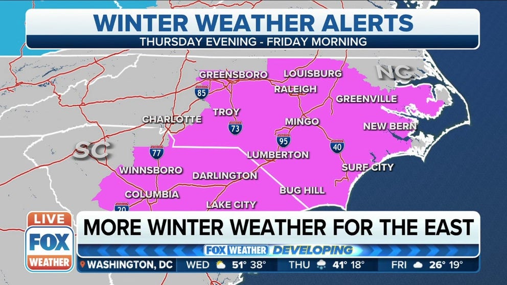
Winter weather alerts issued in NC, SC as winter storm approaches East Coast
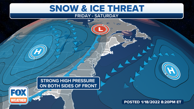
A low-pressure system will likely develop in the Southeast on Friday, then move northward along the East Coast through the weekend.
Another winter storm is brewing for the Southeast and mid-Atlantic late this week, and it's expected to impact many of the same areas that just saw heavy snow and ice over the Martin Luther King Jr. holiday weekend.
The central and eastern Carolinas could be facing a significant ice threat, including the potential for power outages and tree damage, as a wave of low pressure develops near the East Coast.
An arctic high-pressure system will push a cold front through the South and East over the next few days, ushering in another blast of frigid temperatures to allow precipitation from the low-pressure system to fall in the form of snow, sleet and freezing rain as it moves northward along the Southeast and mid-Atlantic coasts.
SLOW, SLEET, FREEZING RAIN AND HAIL: WHAT'S THE DIFFERENCE?
(FOX Weather)
Most computer forecast models are now suggesting the storm will track out to sea by the time it reaches the Northeast Seaboard, which means the threat of accumulating snow is decreasing from New Jersey to southern New England.
However, residents of the Southeast and southern mid-Atlantic still need to prepare for a significant threat of snow and ice beginning as early as Thursday evening.
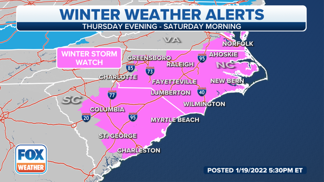
The National Weather Service has already issued Winter Storm Watches for much of the central and eastern Carolinas from Thursday evening through Saturday morning.
WATCH VS. WARNING: HERE ARE THE DIFFERENCES BETWEEN THESE WEATHER TERMS THAT COULD SAVE YOUR LIFE
(FOX Weather)
Winter storm timing
Thursday night through Friday night
The cold front is expected to stall out from the Gulf of Mexico to near the Southeast coast by Thursday night or Friday morning, leaving bitterly cold air in its wake across much of the South and East.
A wave of low pressure developing along the front will squeeze out precipitation, and where temperatures are below freezing, it will fall in the form of snow, sleet and freezing rain from the Southeast to the southern mid-Atlantic.
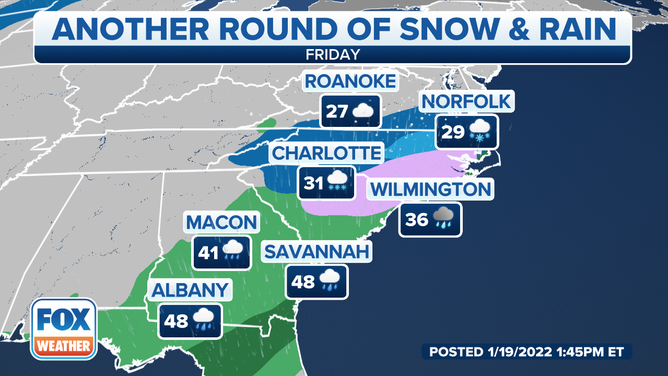
The icy mix will affect areas from east-central Georgia to the coastal Carolinas Friday into Friday night, while snow spreads northward from northeastern Georgia into the Delmarva Peninsula.
A significant ice threat could materialize in the central and eastern Carolinas if current forecast trends come to fruition.
Forecast for Friday, Jan. 21, 2022.
(FOX Weather)
Saturday into Saturday night
Snow and ice are predicted to taper off in the Southeast by mid- to late morning on Saturday as the low-pressure system slides off the East Coast.
It's becoming increasingly likely that the storm will track out to sea rather than up the Eastern Seaboard, so the worst-case scenario might include areas near the Northeast coast getting brushed by some light snow on Saturday.
WHAT MAKES A STORM A NOR'EASTER?
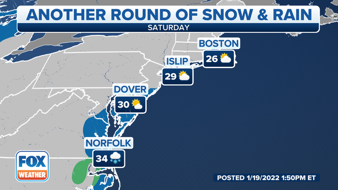
Forecast for Saturday, Jan. 22, 2022.
(FOX Weather)
Expected snow and ice amounts
The best chance to see several inches of snow with this system will be from northern South Carolina into central and northeastern North Carolina and southeastern Virginia. A dusting of snow is possible as far south as northeastern Georgia.
Freezing rain could cause significant icing in the central and eastern Carolinas, especially in the lightest purple-shaded area on the map below.
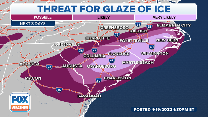
Threat for ice in the Southeast.
(FOX Weather)
As much as a half-inch of ice is not out of the question in parts of the central and eastern Carolinas Friday through Saturday morning.
The ice could become heavy enough in some areas to cause power outages and tree damage, in addition to major travel disruptions.
A glaze of ice is also possible farther south into portions of eastern Georgia, which would still result in icy roads and dangerous driving conditions.
7 THINGS TO KNOW ABOUT ICE STORMS
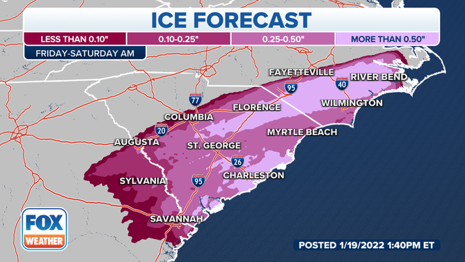
Ice forecast through Saturday morning, Jan. 22, 2022.
(FOX Weather)
Check back with FOX Weather for updates into the weekend. Be sure to download the FOX Weather app to get the latest weather alerts and forecasts for your location.