Dangerous severe storms erupt in upper Midwest
Dangerous severe storms erupt in upper Midwest
Download the AppCoverage for this event has ended.
The threat for severe storms will include part of the Northeast on Thursday.
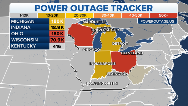
Power outage graphic
PowerOutages.US reports more than 100,000 outages in Wisconsin from the storms. Other places in the Midwest, like Ohio, are still recovering from a derecho that moved through the region earlier this week.
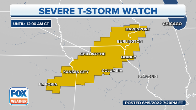
Severe Thunderstorm Watch
A Severe Thunderstorm Watch has been issued ahead of developing storms over parts of the southern Midwest and eastern Plains.
Meteorologists expect storms to develop and they could produce large hail and damaging winds.
Track the storms on FOX Weather 3D Radar: Click Here
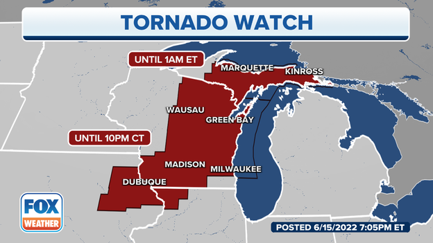
Tornado Watch
A Tornado Watch has been issued for the Upper Peninsula of Michigan into the early morning hours. The watch is only the seventh to be issued for the upper parts of the state since 2010.
Updated forecast: Click Here
Damage has been reported in Oakdale, Wisconsin following a tornado-warned storm.
The president of the Village of Oakdale, Wisconsin says that the tornado caused extensive damage within the town just moments ago.
Richard Lee says that power lines were down and a farm was hit.
Lee says that emergency officials are working to survey the damage and no word of any injuries at the moment.
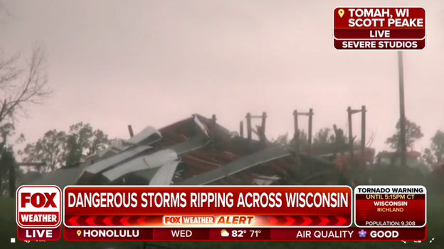
Storm damage in Tomah, Wis.
Storm chaser Scott Peake shows storm damage in Tomah, Wisconsin, after a confirmed tornado moved through the town.
FOX Weather
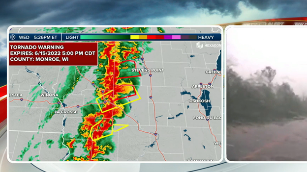
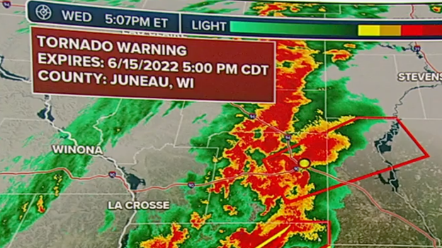
Several Tornado Warnings have been issued in Wisconsin as a powerful line of dangerous storms tears through the state.
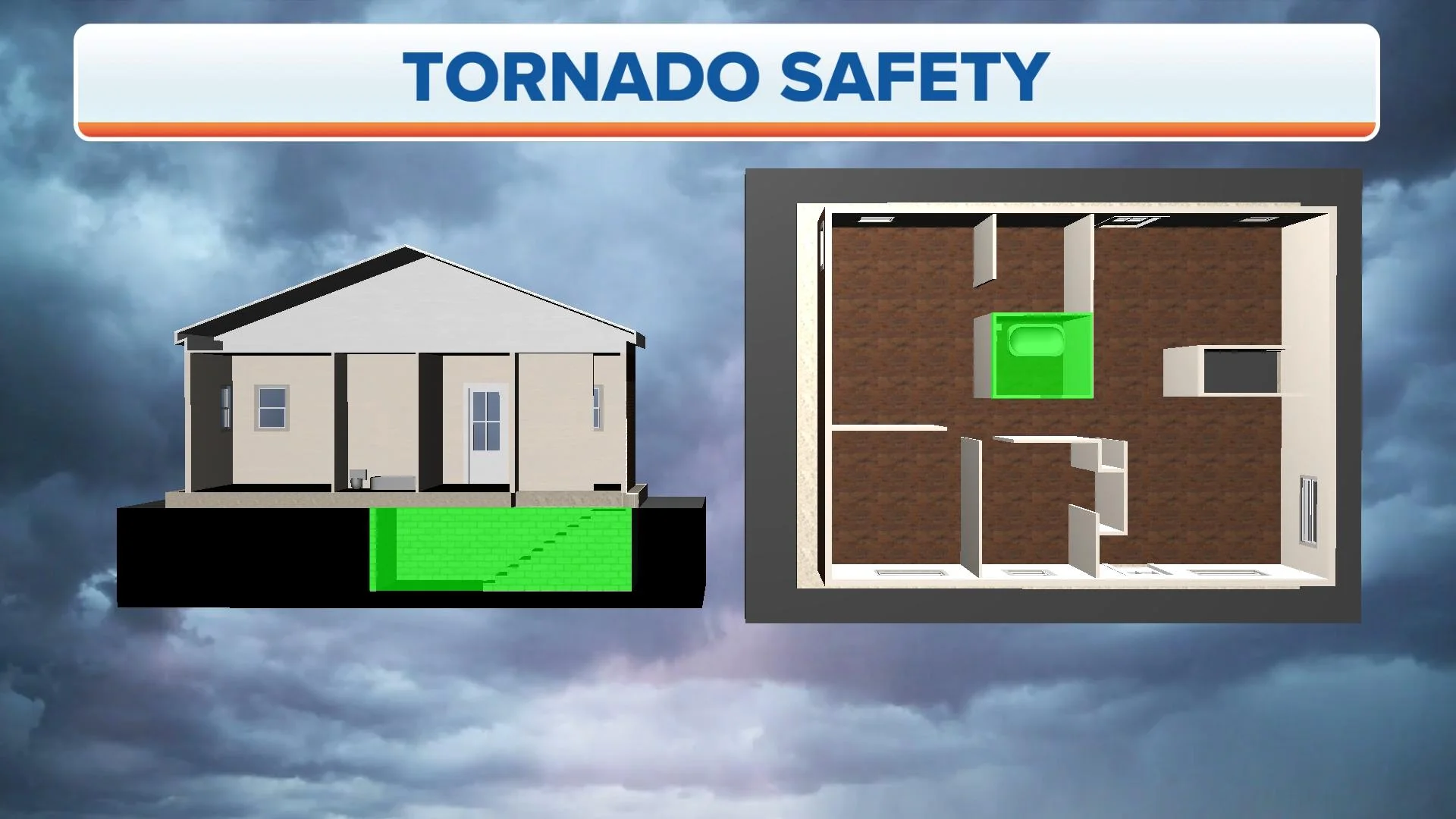
Anyone inside any of the warned areas should immediately seek shelter in a basement, storm shelter or an interior room on the lowest level of a building.
FOX Weather
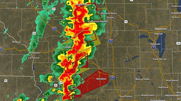
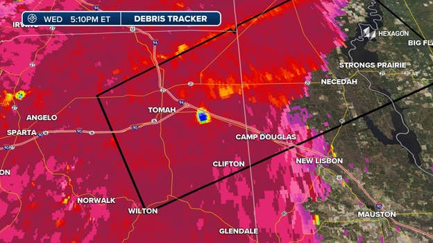
Two so-called "debris balls" showed up on radar Wednesday afternoon with storms tearing through Wisconsin.
This type of radar signature usually means that a tornado is on the ground and causing damage. The "balls" appearing in the image is the radar detecting debris that is being thrown into the air.
Tornado Warnings have been issued for both of these storms. People who live in the path should immediately seek shelter.
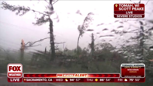
Trees snapped in Tomah, WI
A confirmed tornado was on the ground moving through Tomah, Wisconsin Wednesday afternoon.
Storm chaser Scott Peake shows us the damage of trees that were snapped in the tornado's path.
Severe weather coverage
Tornado-warned storms are moving towards Interstate 39 in Wisconsin. The severe storm threat will continue across the Badger State for the next several hours.
Download the FOX Weather app to track the storms on 3D radar: Click Here
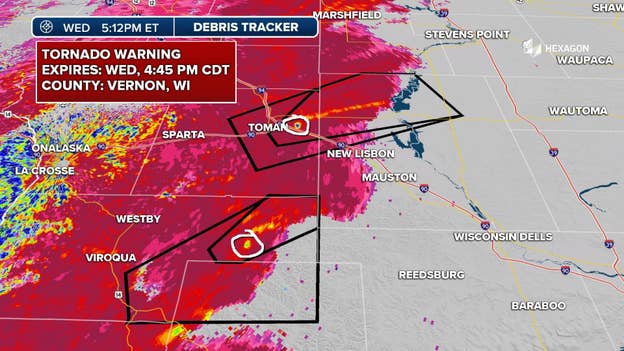
FOX Weather
A radar signature known by meteorologists as a "debris ball" has been detected with a tornado-warned storm near Tomah, Wisconsin. This type of signature usually indicates that a tornado is on the ground and is causing damage. The "ball" appearing on the image is the radar detecting debris that is being thrown into the air.
A Tornado Warning has been issued for this storm until 5 p.m. People living in the path of this storm should seek shelter immediately.
Active Tornado Warning in Wisconsin
The NWS in La Crosse issued a new Tornado Warning fro northeast Vernon County through 4:45 p.m. CDT.
A severe thunderstorm capable of producing a tornado is moving northeast at 45 mph. The storm will be near Hillsboro around 4:20 p.m.
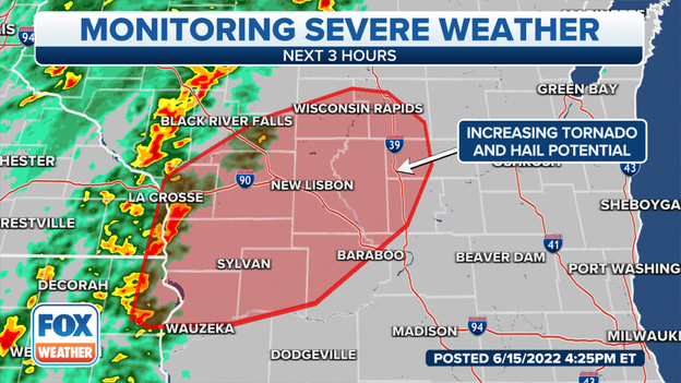
Area of concern for severe weather in next 3 hours
There is an increasing tornado and hail threat in the red area with ongoing storms this afternoon and evening.
Fire and rescue officials in Patch Grove recorded a 65 mph wind gust and report pea size hail is coming down as the severe thunderstorm moves east.
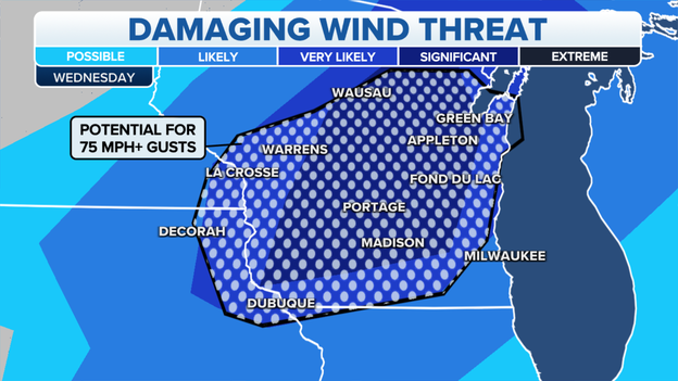
Damaging wind gust outlook for Wednesday.
Damaging winds with gusts over 75 mph are possible with tonight's thunderstorms.There is a significant chance of damaging winds in Portage, Madison, Green Bay and Appleton.
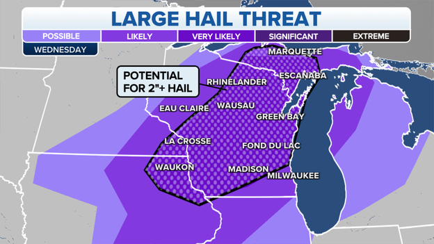
Large hail threat forecast for Wisconsin Wednesday night.
Severe thunderstorms are bringing the threat of large hail potentially over 2 inches to major cities including Green Bay and Madison.
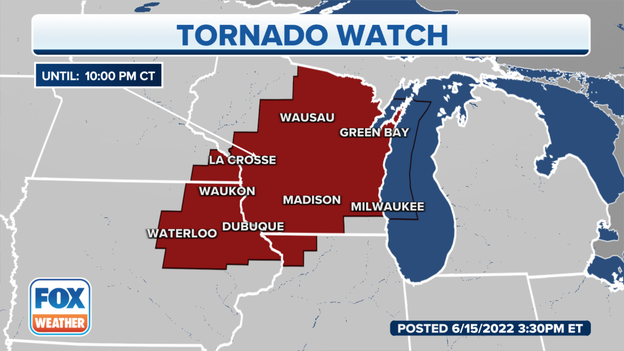
Active Tornado Watch until 10 p.m. CDT.
The Storm Prediction Center has issued a Tornado Watch until 10 p.m. CDT for Northeast Iowa, Northwest Illinois, Southeast Minnesota, Wisconsin and Lake Michigan.
The primary threats will be a few tornadoes, large hail up to 3 inches and 75 mph wind gusts.
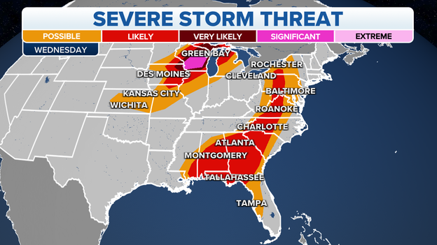
Wednesday, June 15, severe weather outlook.
Forecasters with NOAA's Storm Prediction Center are closely monitoring an area of convection expected to develop in Northeast Iowa, southeast Minnesota, part of south-central Wisconsin and northwest Illinois.
Tornadoes, damaging hail and wind gusts are possible as severe thunderstorms move across parts of the upper Midwest and upper Great Lakes Wednesday night.
You’ve reached the beginning of this live coverage.