What is an Omega block?
This atmospheric phenomenon, which resembles a Greek letter, acts as an atmospheric "traffic jam" that locks weather patterns in place.
What is an 'Omega block' weather pattern?
Named for its resemblance to the Greek letter Ω, an Omega block occurs when two low-pressure systems become cut off from the main flow of the jet stream, sandwiching a high-pressure system between them.
Many weather patterns earn their name simply by how they look – an Omega block is one of them.
WHAT ARE EL NINO AND LA NINA CLIMATE PATTERNS?
An Omega block is a stagnant weather pattern named for its resemblance to the Greek letter Ω.

An Omega block is a weather pattern where the jet stream gets stuck in a shape that looks like the Greek letter Ω (omega).
(FOX Weather)
It occurs when a large ridge of high pressure becomes sandwiched between two areas of low pressure on either side – creating the Omega image.
This setup acts as an "atmospheric traffic jam" – bringing the existing weather patterns to a halt in place, allowing existing conditions to persist for longer than normal.
HOW HIGH PRESSURE AND LOW PRESSURE DRIVE THE WEATHER
In this blocking pattern, cooler temperatures and precipitation accompany the lows, while warm and clear conditions prevail under the high.

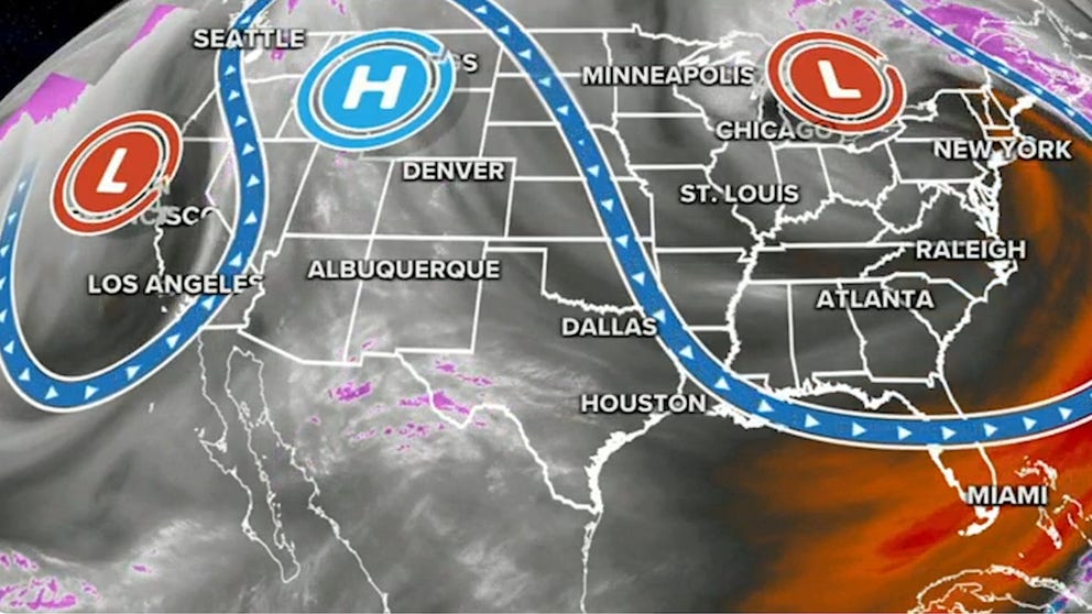
In this example, an area of low pressure in the Pacific Northwest, a big ridge of high pressure in the central U.S. and an area of low pressure in the Northeast create the Omega shape on this weather map.
(FOX Weather)
Omega blocks are usually large, which means they are one of the more stubborn blocks to break down.
This can create concerns about flooding where the wet weather persists, and drought worries where the dry weather happens.