Watch: Saildrone captures towering waves inside Hurricane Idalia
NOAA said this Saildrone withstood sustained tropical storm-force winds for more than nine hours and waves as high as 31 feet.

Watch: Saildrone sails through Hurricane Idalia
A Saildrone captures images inside Hurricane Idalia. (Courtesy: NOAA and Saildrone, Inc.)
On Thursday, NOAA released a video showing images from a Saildrone floating inside Hurricane Idalia as it churned through the Atlantic Ocean on Aug. 29, giving forecasters real-time data inside the storm.
"We're pretty excited," NOAA Saildrone Science Lead Greg Foltz told FOX Weather. "We’ve been doing this for about three years now. We’ve gotten them into several hurricanes and gotten really good data."
Saildrones are wind- and solar-powered uncrewed surface vehicles that collect data when sailing on the open ocean, according to Saildrone, Inc. They use historical storm tracks to strageically place drones in the Gulf of Mexico, Atlantic Ocean and Caribbean Sea.
New video from Saildrone 1083 floated within Hurricane Idalia, providing an inside look at the storm. Images from the vehicle show the dark, gray-blue waters of the Atlantic rise and fall amid 31-foot swells with the backdrop of thick clouds blocking the horizon.

How saildrones sail into the eye of hurricanes to collect critical data
NOAA Saildrone Science Lead Greg Foltz explains how these uncrewed drones sail into the heart of nature's fury and collect vital real-time data to help forecasters and computers better calculate a hurricane's ultimate plans.
SAILDRONE DEPLOYING RECORD 12 DRONES TO HUNT HURRICANES IN ATLANTIC, GULF OF MEXICO
The choppy waters tilt the Saildrone back-and-forth, giving viewers a peek at the energy inside Idalia. The drone survived nine hours inside tropical-storm-force wind.
On Aug. 29, the Saildrone passed through the north side of Idalia’s eye wall and then into the eye of the hurricane itself. According to NOAA, the vehicle then passed through the southern eye wall, all while multiple dropsondes were deployed over the Saildrone from the NOAA P-3 aircraft.
It's all in the quest for better hurricane forecasts.
"The idea is to get that data and analyze it, do scientific research and improve the forecast models," Foltz said. "And also put that data into forecast centers in real time so that it goes into the forecast models, and they can use it in hurricane intensity forecasts."
Idalia is not their first success. In their first year of research two years ago, they managed to get a drone into the middle of Category 4 Hurricane Sam. This year, they've sent a record number of drones out to sea, peppering the Gulf of Mexico and Atlantic with drones, hoping to better positioned to find more storms.
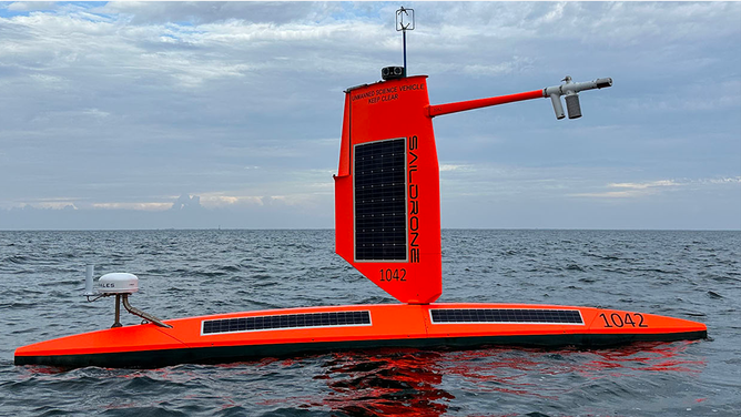
FILE: A Saildrone equipped with a special "hurricane" wing to collect data for the 2023 Atlantic hurricane mission.
(Saildrone / FOX Weather)
Two Saildrones managed to reach Hurricane Franklin while it was in the North Atlantic, while another went through the eye of Idalia when it was in the Gulf of Mexico.
"We really didn’t have to move it much, just some fine-tuning to get it through the center of that storm," Foltz said. Two other drones off South Carolina managed to sample what was then Tropical Storm Idalia on its exit off the Southeast coast.
Foltz says the drones are well positioned to sample Hurricane Lee as the monster storm slowly makes its way north off the Eastern Seaboard this week.
"We have some Saildrones lined up along it western track and in the next few days we have a really good shot at getting them into the eye wall – potentially when it's still a (Category) 5," he said.
All data collected will be sent in real time to the National Hurricane Center and all other international forecast centers, plus be available for any forecast model runs.