50-foot waves and 120 mph wind: Saildrone video takes us inside Hurricane Sam
New footage from an unmanned "saildrone" is bringing us a first glimpse of what it's like to sail into the heart of a Category 4 hurricane.
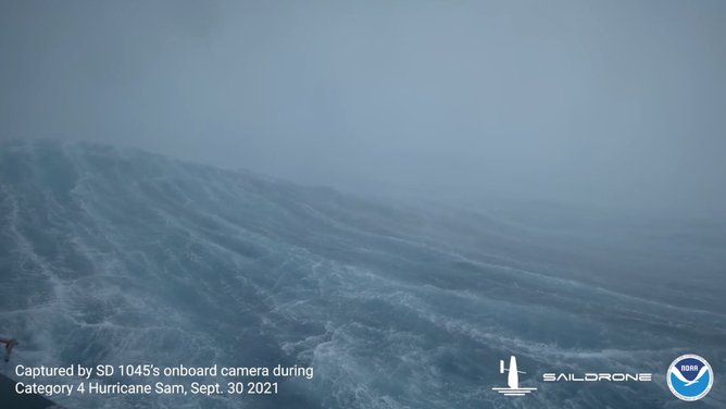
View from inside Hurricane Sam from a Saildrone
(Saildrone / NOAA)
ATLANTIC OCEAN -- New footage from an unmanned "saildrone" is bringing us a first glimpse of what it's like to sail into the heart of a major hurricane.
The 23-foot vessel was sent into the path of Hurricane Sam, which is swirling several hundred miles off the Eastern Seaboard.
As the drone sailed just northeast of the storm's eye, a video camera onboard captured 50-foot waves as 120 mph wind roared outside, the company and NOAA announced in a press release Thursday afternoon. It's said to be the first video footage taken inside a hurricane from an uncrewed surface vehicle.
The hurricane is currently rated as a Category 4 storm with peak winds of 145 mph.
The drone is one of a fleet of five sailing in the Atlantic, aiming to get into the path of hurricanes and collect crucial weather data.
The bright orange surfboards can survive the extreme wind and wave conditions thanks to specially-designed "hurricane wings."
The vessels are controlled remotely via satellites at home base and travel at roughly 3.5 miles per hour. Powered by wind and solar energy, the drones can stay deployed for up to a year about a year.
"We can steer these vehicles into the path of the storm," Saildrones CEO Richard Jenkins told FOX Weather in an earlier interview. "And we’ll maneuver them as long as the storms keep coming."
![]() Image 1 of 5
Image 1 of 5The view inside Hurricane Sam from a saildrone. (Saildrone)
![]() Image 2 of 5
Image 2 of 5The view inside Hurricane Sam from a saildrone. (Saildrone)
![]() Image 3 of 5
Image 3 of 5The view inside Hurricane Sam from a saildrone. (Saildrone)
![]() Image 4 of 5
Image 4 of 5The view inside Hurricane Sam from a saildrone. (Saildrone)
![]() Image 5 of 5
Image 5 of 5The view inside Hurricane Sam from a saildrone. (Saildrone)
In addition to the video, the drones will feed back real-time data like wind speed, humidity, water temperature, barometric pressure, water currents and other vital signs at the surface, which will be fed into computer forecast model projections.
"Putting the data into NOAA's forecast models will help better predict intensity (of hurricanes)," Greg Foltz, a NOAA scientist, told FOX Weather. "And that, of course, leads to better lead times for things like warnings for storm surge and high winds."
Typically, forecasters measure wind and pressure with planes and dropsondes. Still, to truly understand how much heat is coming from the ocean, we need to collect data above and below the ocean's surface.
"The main goal is to get this data to help improve understanding of how the energy exchanges from the ocean to the atmosphere," Foltz said. "That is what fuels hurricanes. It’s that warm ocean, giving energy to the hurricane."
Hurricane season runs until the end of October and the tropics remain active, potentially giving saildrones more targets later this autumn.
In the meantime, Hurricane Sam is expected to remain well offshore and poses no threat to North America.