Watch: Waterfall swells from trickle to rage after historic drought ends with multiple rainstorms
What a difference two weeks can make along a mountain river. Western Washington had been parched under a historic dry stretch for months, but watch what happens when the rains finally returned.

Watch: Washington's Snoqualmie Falls swells after heavy rains hit Cascades
The falls along the Snoqualmie River went from a relative trickle on Oct. 18 to a fully-raging waterfall by Nov. 1. (Video: Sigma Sreedharan Photography)
SNOQUALMIE, Wash. – What a difference two weeks can make along a mountain river.
Popular tourist attraction Snoqualmie Falls, nestled in the Washington Cascades east of Seattle, was barely at a trickle when photographer Sigma Sreedharan paid a visit on Oct. 18.
The region had been parched under a historic dry stretch for months. The Seattle area set its all-time record for the driest 120-day stretch of weather from mid-June to mid-October – just 0.54 inches. That was a third of what Death Valley received in one day.
But then the proverbial switch was flipped in the atmosphere, ushering in a soggy stretch of weather that has brought several days of rain to the region – with plenty more to come.
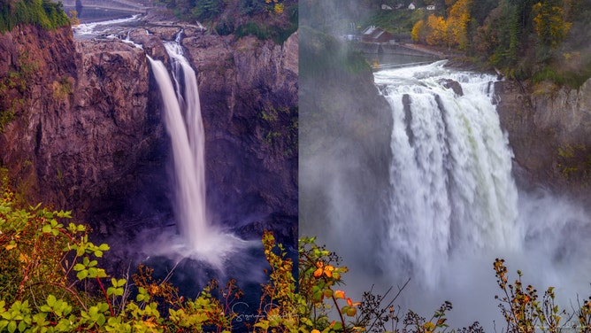
Snoqualmie Falls, Wash. on Oct. 18, 2022 (left) and Nov. 1, 2022 (right)
(Sigma Sreedharan Photography / FOX Weather)
Roughly 5 inches of rain fell in the central Cascades over the past couple of weeks, turning Snoqualmie Falls from a waterfall into a WATERFALL.
More heavy rain coming for the Cascades
And the falls may just be getting started. A sizable and potent atmospheric river is heading toward the Pacific Northwest for the end of the week, promising several more inches of rain and bringing the potential for minor to moderate river flooding along the Snoqualmie River, which feeds the falls.