Pacific Ocean likely to see 2 'double bomb' cyclones in same week
After a "bomb cyclone" nabbed headlines across the nation with its rapid strengthening in the Pacific Ocean Wednesday and Thursday, a new storm is about to put on a similar show --and attempt to outdo its predecessor.
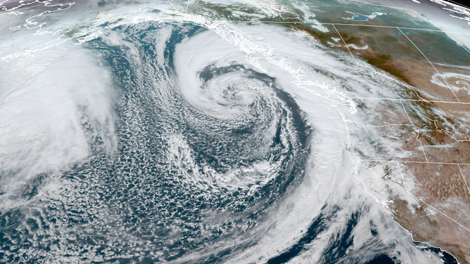
Satellite imagery shows a "Double Bomb Cyclone" in the Pacific Ocean on Oct. 21, 2021.
(CIRA/RAMMB / NOAA)
SEATTLE -- After a "bomb cyclone" nabbed headlines across the nation with its rapid strengthening in the Pacific Ocean Wednesday and Thursday, a new storm is about to put on a similar show --and attempt to outdo its predecessor.
A "bomb" cyclone is simply a meteorological term that describes when a storm's central pressure drops 24 millibars within 24 hours, indicating rapid intensification.
But the storm that formed off the West Coast Wednesday into Thursday managed to double that feat; its central pressure dropped from 1001 mb to 951 mb in 24 hours -- a staggering 50 millibar drop and qualifying it as a "Double Bomb Cyclone."
And now, a new storm developing in the Pacific Ocean will undergo a similar process -- and perhaps become even more potent than the earlier storm. Computer forecast model projections indicate this new storm will again drop 50 millibars -- maybe even 51 -- in 24 hours, from around 994 millibars Saturday morning to 943 millibars by Sunday morning.
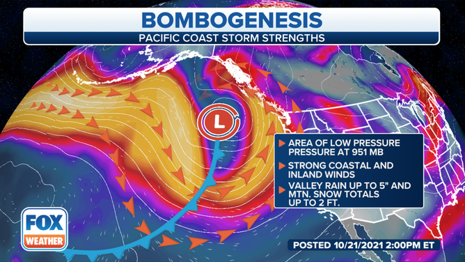
(FOX Weather)
That would make this week have double-double bomb cyclones!
The first storm gradually pulled away from the Pacific Coast and weakened, bringing a period of rain and gusty winds but no significant impacts.
The second storm is predicted to come closer to the Washington and British Columbia coast, increasing the wind threat. However, the storm is expected to gradually weaken as it approaches land and veer north, keeping Washington safe from extreme impacts.
On the other hand, the new storm will steer a strong atmospheric river into Northern California, carrying several inches of rain in the lowlands and increasing the threat of flooding.