Hurricane Idalia leaves marks on Florida's coastline that are visible from space
As Idalia's Category 3 and 4 winds of 110-130 mph churned the waters just miles from Florida's shore as it approached Wednesday, raging waves stirred up the widespread areas of dirt and sediment from the shallow seafloor to the surface.

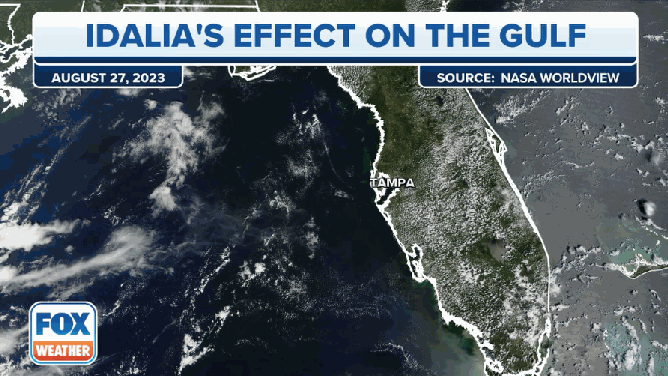
Look how Hurricane Idalia churned up the Gulf of Mexico
Strong 100+ mph winds from Hurricane Idalia was like a blender in the Gulf of Mexico, churning up sediment as it reached Florida's Big Bend area -- a process you can see from space.
KEATON BEACH, Fla. – Not only did the strong winds and rushing storm surge of Hurricane Idalia leave its mark on the Florida shores, but it also left marks on the offshore waters that were visible from space.
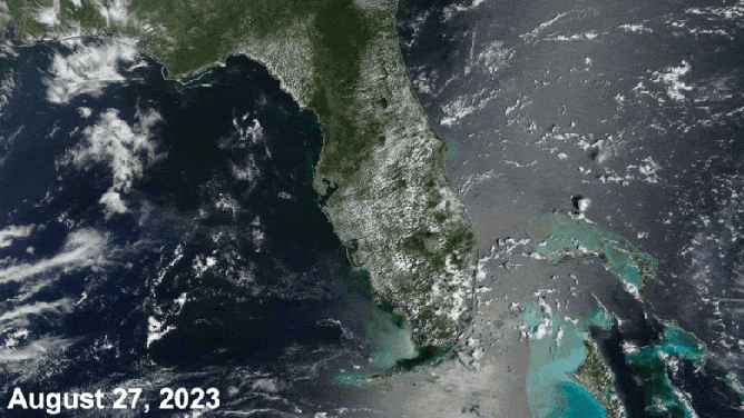
Satellite imagery from NASA'a MODIS satellite showed pristine blue waters along the Florida coast on Aug. 27 – just days before Idalia would crash ashore at Keaton Beach.
LOSSES FROM HURRICANE IDALIA EXPECTED TO TOP $10 BILLION
As Idalia's Category 3 and 4 winds of 110-130 mph churned up the waters just miles from shore as it approached Wednesday, raging waves stirred up the widespread areas of dirt and sediment from the shallow seafloor to the surface.
Hurricane Idalia stirred up quite a bit of dirt and sediment as it swirled over Florida's Gulf Coast this week.
(MODIS / NASA)
"After Idalia moved on through, it was like a big mixing bowl," said FOX Weather meteorologist Michael Estime. "And then you can see all the sediment on the western edge of Florida that you can see on visible satellite imagery."
Indeed, the storm's impacts were so large that the discolored water was visible from 22,000 miles above in space.
"Florida and the Florida coastlines, they're pristine," said FOX Weather meteorologist Stephen Morgan. "And also those shallow waters it’s beautiful and picturesque to see even the sand getting kicked up that does speak to just the depths that this churning goes through."
(FOX Weather)
It's a common occurrence after strong storms to see such visible scars in the offshore waters, though eventually, the sediment resettles, and the waters return to their usual clearer state.
7 FACTS TO KNOW ABOUT HURRICANES
Idalia cooled off the Gulf – a little
Estime said that not only did Idalia churn up dirt, but it also brought some cooler water to the surface.
"(Idalia) moved around not only the warm water from the top layer to the bottom, but it brought some of that cooler water from the bottom to the top," Estime said.
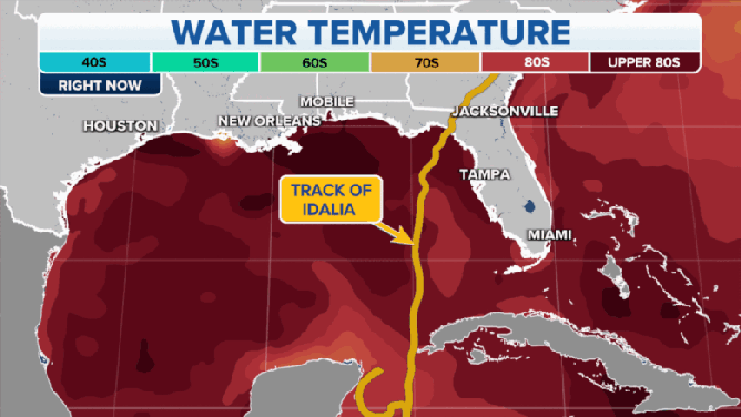
Before and after maps show the cooling effect Hurricane Idalia had on the Gulf of Mexico.
(FOX Weather)
A buoy off the coast of Florida's Big Bend area showed a drop in water temperature from 88 to 84 degrees after Idalia passed.
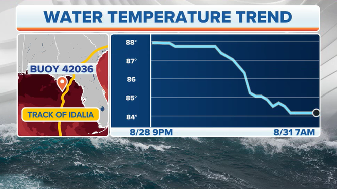
Buoy 42036 showed a water temperature drop of 4 degrees when Hurricane Idalia passed in late August.
(FOX Weather)
Morgan noted that while any cooler water helps, the Gulf temperatures are still well over 80 degrees -- plenty warm for tropical development.
"We do notice some slightly cooler temperatures," Morgan said. "That's relative, though, because for a hurricane to strengthen, all you need is about 80 degrees."