Hawaii braces for flooding as Kona Low delivers heavy rain, thunderstorms this week
A Kona Low shifts the wind, which can fuel days of heavy rain and mountain snow over Hawaiian towns that are usually dry. A big concern is flash flooding over recently burned Lahaina.
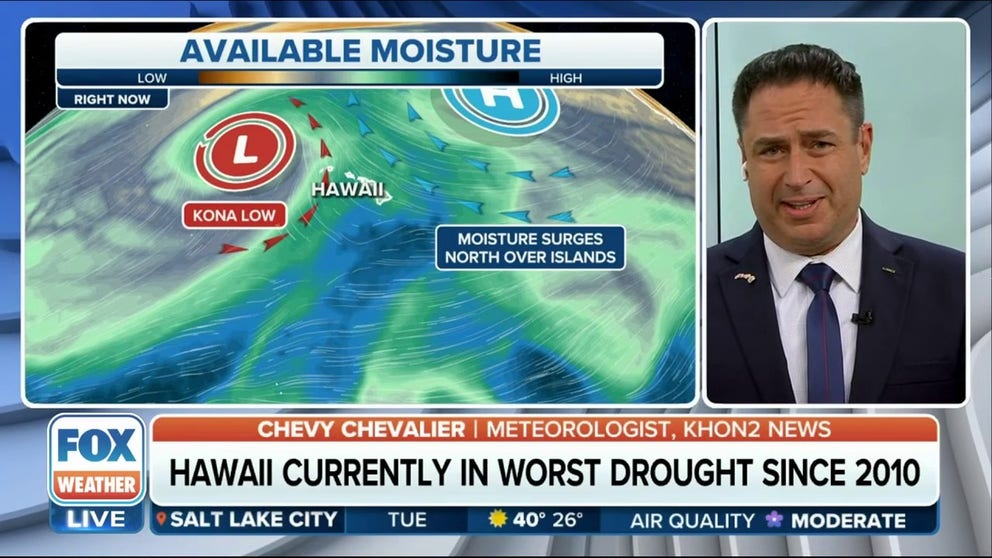
Kona Low means days of rain for Hawaii
KHON2 Meteorologist Chevy Chevalier joins FOX Weather to explain how a storm called a Kona Low could mean a washout this week to Hawaii vacationers.
HONOLULU – Heavier showers and thunderstorms are in the forecast as an Kona Low is poised to deliver several inches of rain to Hawaii and recent burn scars. The National Weather Service, Honolulu placed the entire state under a Flood Watch.
Already, the NWS has reported rainfall rates of an inch an hour over Kauai and Oahu. The low pushes east through the work week.
"As the surface and upper level lows become more aligned over the next 24 hours, we can expect to see heavier showers and thunderstorms over and near the islands," wrote the Honolulu NWS in the forecast discussion.
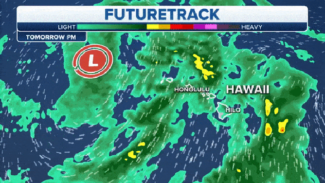
Futuretrack keeps rain over the state through Saturday but downpours should be lighter starting Thursday.
(FOX Weather)
That unstable tropical moisture will push rain, which will be heavy at times, and thunderstorms across the entire state from Wednesday through Saturday.
"Obviously, we have some pretty extreme drought conditions across the state, especially on the Leeward areas and that's where these things really impact us," KHON2 Meteorologist Chevy Chevalier told FOX Weather.
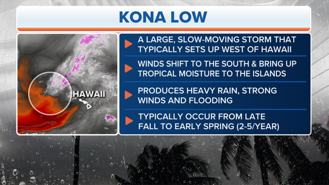
A Kona Low.
(FOX Weather)
"These Kona Lows tend to stick with us for quite some time," he continued. "So I'd say flooding is our biggest concern, especially, you know, a lot of heavy rain on top of that dry ground like water on a dry sponge. It tends to run off and give you a flash flooding a lot faster."
Flood Watches posted across Hawaii
Several inches of rain could fall across all of the Hawaiian Islands this week. Honolulu, for example, could pick up a few inches of rain through Saturday.
Hilo, on the Big Island of Hawaii, could also see 2 to 3 inches of rain, to 5 at the highest elevations, by the time the system moves away from the state. Downed trees will be a problem.

(FOX Weather)
"When we get any kind of winds with saturated grounds, we get trees fallen and we get power lines down quite a bit," Chevalier said.
The NWS said flood-prone roads and low-lying areas may need to be closed due to the elevated runoff and overflowing streams. In addition, the NWS warned that urban areas may receive more significant flooding and property damage due to the rapid runoff.

(FOX Weather)
HOW MOUNTAINS CAN HOG THE RAIN
Drought ravaged regions and burn scars expecting the heaviest rain
"Since the leeward side of the islands don’t get as much rain, they tend to be drier with less vegetation and shallower soil," NOAA says. "These conditions make these areas more vulnerable to floods, along with landslides and mudslides, especially in mountainous areas with steep, sloping inclines. The state’s Big Island has endured some of the worst impacts after experiencing ‘catastrophic flooding’ where two feet of rain fell in some areas and knocked out power throughout the islands."
Another concern is flooding rain falling on burn scars in Maui.
"Since the fires from August 8th, that area, Lahaina and leeward, portions of Maui especially, everything's gone," Chevalier said. "And the problem there is when you get heavy rain, there's really no buildings and the sewer systems are clogged and you get a lot of runoff fast. They don't need that."
WHEN CAN MAUI START REBUILDING? HOW TOXIC DEBRIS FROM DEADLY FIRES IS SLOWING RECOVERY
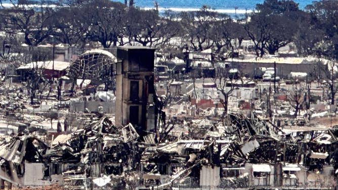
File: The burned out town of Lahaina.
(Robert Ray / FOX Weather)
The fire burned homes, commercial buildings, cars, asbestos and plastics which released toxic substances. The ash and soil are contaminated. Flash flooding can wash the toxins into the ocean and water supplies.
"But they did a great job of cleaning up the toxic waste. They got most of it out of there. So we think there will be minimal impacts when leeward portions of Maui start to get the heavy rain," Chevalier explained. "They barricaded it out of the ocean to protect the ecosystem there, too."
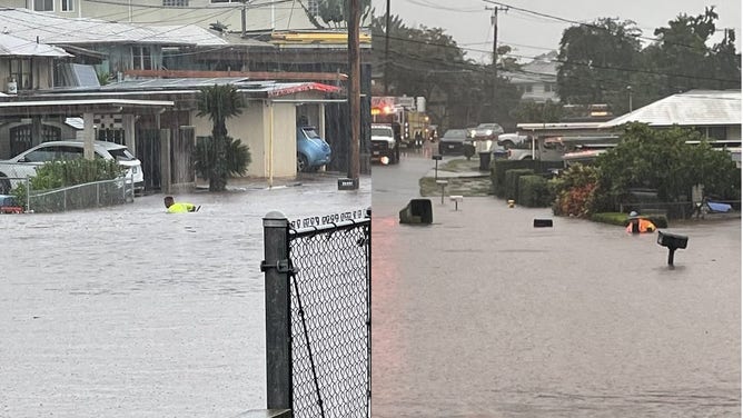
The Pearl City Road Maintenance Division had to wade chest deep in floodwater to clear storm drains in December 2021.
(Honolulu Mayor/Honolulu DEM / NOAA)
Why Kona Lows can be so dangerous
The Kona Low that dropped 2 feet of rain in December 2021 closed highways on Maui and washed cars away. On Oahu, one highway was under waist-deep water, according to the NWS. Tropical-storm-force winds (39-plus mph) blew a shed into planes at the Honolulu Airport, damaging the aircraft. Winds gusted over 100 mph at the summit of Mauna Kea, which created near-blizzard conditions, blowing around the 10 inches of snow that fell.
HOW A TROPICAL PARADISE IS HOME TO THE RAINIEST SPOT IN THE NATION
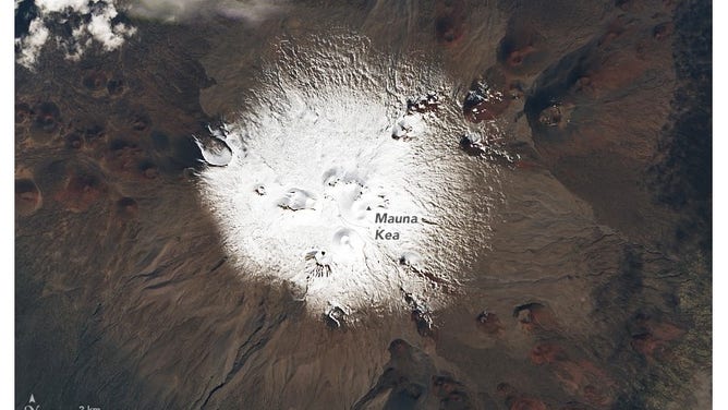
File: Satellite images show the snow on Mauna Kea on Dec. 7, 2021.
(earthobservatory.nasa.gov / NASA)
"Kona Lows originate from a deep kink in the jet stream (a band of strong winds high in the atmosphere that steer weather systems) that sinks south and pinches off, leaving behind a low-pressure circulation that is cut off from the main core of the jet," NASA says. "These cut-off lows can linger for several days."
A Kona Low dropped a record-setting 49.69 inches of rain in 24 hours over Waipa Gardens on Kauai on April 14-15, 2018.
Silver lining? Ease the drought
Easing the drought is the silver lining to the flood threat for Hawaii. Over 93% of the state is in moderate drought, and 75% is in severe drought, according to the latest U.S. Drought Monitor.
REMOTE HAWAII WILDFIRE COULD LEAD TO NEXT LAHAINA TRAGEDY, EXPERTS WARN
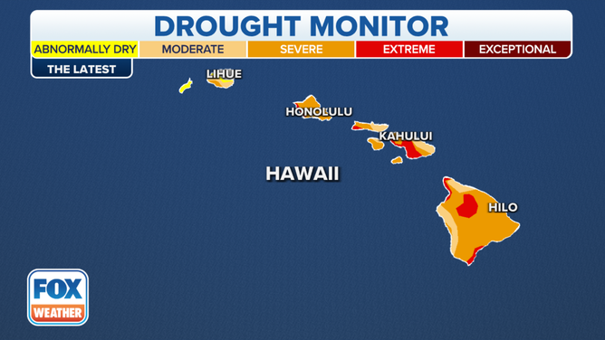
The Hawaii drought monitor.
(FOX Weather)
Officials say drought conditions helped spark the deadly Lahaina firestorm over the summer.