Blizzard expected to hit tonight as winter storms blanket Rockies, Plains, Upper Midwest
The first storm is located over the central U.S. on Tuesday. Meanwhile, the second storm is still taking shape. Both storms will pack a punch that includes snow on the colder side and the potential for severe weather on the warmer side.
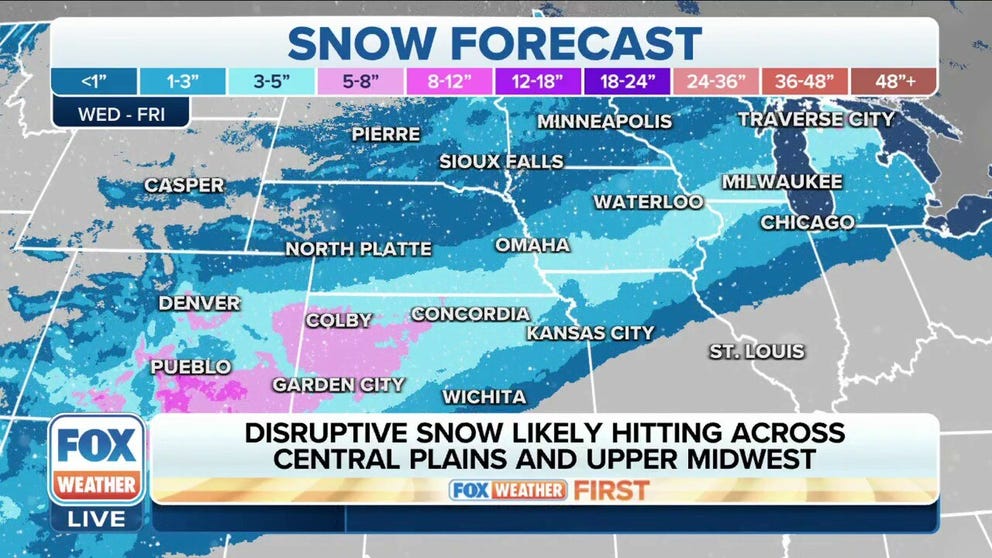
Winter storm to dump heavy snow across Central Plains, Upper Midwest
On the cold side of storm #2, a dangerous winter storm is expected through Friday. Snow rates exceeding 1"/hr and wind gusts above 40 mph will make blizzard conditions possible, especially in the Southern High Plains.
Millions of Americans are in the path of not one but two powerful storms targeting the U.S.
The first storm is located over the central U.S. on Tuesday. Meanwhile, the second storm is still taking shape. Both storms will pack a punch that includes snow on the colder side and the potential for severe weather on the warmer side.
"If you have anything outdoors to do, I would highly recommend that you do it today rather than wait, because this is going to end up being one of those storms that is likely going to create some slick spots as well as some fender benders," FOX Weather meteorologist Jason Frazer said.
(FOX Weather)
Storm No. 1: Fewer impacts
The first potent storm moved into the central U.S. on Tuesday after battering parts of the Southwest at the start of the workweek.
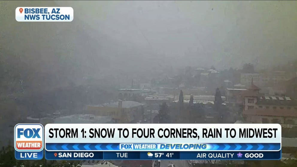
Storm brings snow to southeastern Arizona
Time lapse video captures snow falling in Bisbee, Arizona.
As the storm moves across the region, a lack of cold air will lead to mostly rain across the central states. The FOX Forecast Center said 2 inches of rain would be possible with this first storm.
The exception will be parts of the Dakotas and Minnesota, where up to 5 inches of snow will be possible.

(FOX Weather)
As the storm system races northeast from Tuesday night into Wednesday, winds will pick up across the region, and blizzard conditions are likely during the morning hours Wednesday.
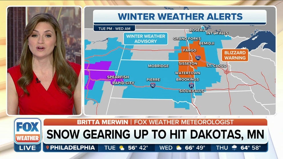
Blizzard conditions likely across the Dakotas, parts of Minnesota
A potent storm is brewing across parts of the Central U.S., after battering parts of the Southwest Monday. As the storm system races northeast Tuesday night into Wednesday, winds will pick up across this region, and blizzard conditions are likely during the morning hours on Wednesday.
The criteria for a blizzard has nothing to do with how much snow falls. It is all about the visibility and winds. A blizzard must have wind gusts of 35-plus mph and a visibility of a quarter-mile or less over a period of at least three hours.
WHAT MAKES A BLIZZARD DIFFERENT FROM AN ORDINARY SNOWSTORM

(FOX Weather)
Storm No. 2: Heavy snow possible later this week
As for the second winter storm, light snow will initially break out across the mountains of Wyoming, Utah, Arizona and Colorado on Tuesday morning. Few, if any, impacts are expected. That will change by Tuesday evening as a strengthening upper-level low-pressure system swings into the Four Corners.

(FOX Weather)
The FOX Forecast Center said a band of heavy snow and high winds will develop and work from west to east across the region. It will first smack northern Arizona and southwestern Colorado on Tuesday night before slamming New Mexico and Colorado on Wednesday.
Up to a foot of snow will be possible with this storm.
DRIVING ON THE ICE AND DRIVING IN THE SNOW: WINTER DRIVING TIPS FOR DRIVING IN INCLEMENT WEATHER

(FOX Weather)
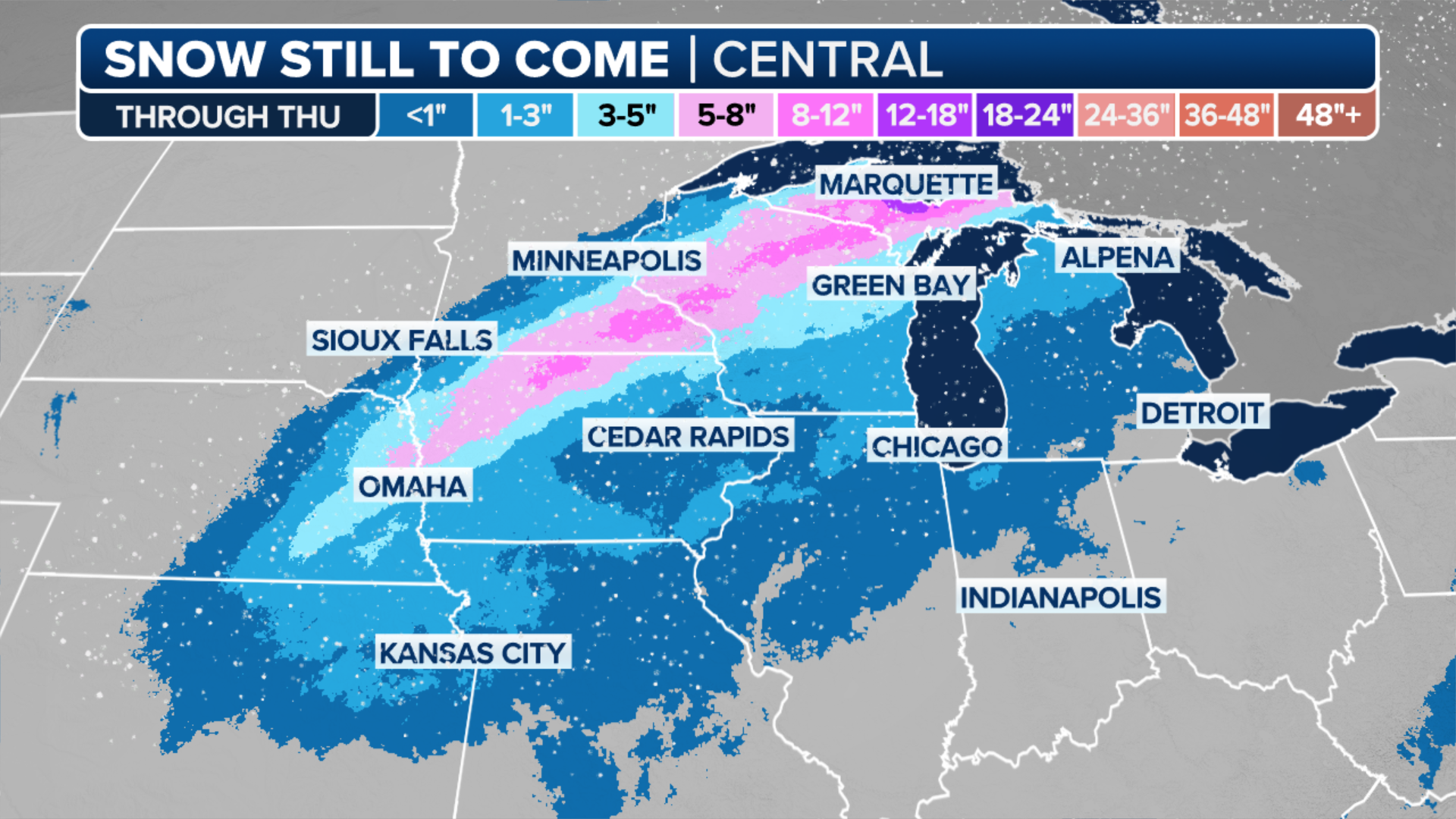
Across the Plains, confidence is increasing that an area of heavy snow is likely from northern Kansas through Iowa and Wisconsin. This snow will begin Wednesday night and last into Friday.
Travel impacts are likely, along with school closures. Exact snowfall amounts remain uncertain, but 5-plus of snow inches appears likely.
(FOX Weather)