Winter Storm spanning over 2,100 miles to blast heavy snow, hazardous ice from central Plains to mid-Atlantic
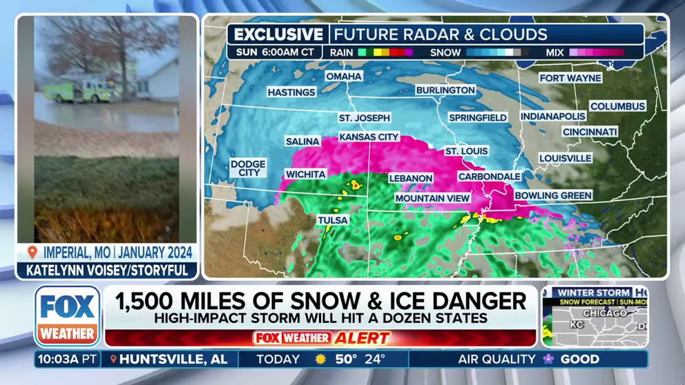
On Sunday, the central Plains and lower Ohio Valley will experience a mix of heavy snow and ice. On Sunday night, the rest of the Ohio Valley, Mid-South, Central Appalachians and possibly the mid-Atlantic will be affected.
High-impact winter storm to hit 12 states in 2,100 miles of snow, ice
A high-impact winter storm willl drop a mix of heavy snow, sleet and dangerous freezing rain from the West Coast to the mid-Atlantic through Monday.
KANSAS CITY, Mo. – Winter Storm and Ice Storm Warnings are now growing across the Midwest ahead of America's first high-impact winter storm of the new year. The coast-to-coast event is expected to bring a swath of hazardous snow and ice across the central and eastern U.S.
The storm is roaring ashore on the West Coast Friday, bringing heavy rains and mountain snow to the Pacific Northwest and northern California. From there, it will bring a round of snow to the Intermountain West and northern Rockies on Saturday before emerging in the Plains on Saturday night.
WINTER STORM LIVE TRACKER: SNOWFALL MAPS, CURRENT ALERTS, POWER OUTAGE FORECASTS
"This is the big one," Chief Safety and Operations Officer Becky Allmeroth, with the Missouri Department of Transportation, told FOX Weather on Friday as state officials prepare for the worst.

(FOX Weather)
That's when the stage becomes set for a significant winter storm. The FOX Forecast Center said north of the storm, a strong ridge of high pressure will be supplying cold air, while to the south, moisture from the Gulf of Mexico will be flowing north.
Winter weather alerts now include Winter Storm Warnings for the Kansas City area ahead of the storm that is expected to track from the Northwest and Rockies to the Midwest and Ohio Valley. Ice Storm Warnings are in effect for a few counties in southern Missouri for as much ice accretion as 0.5-0.75 inches.
Already, several major airlines, including United, American, Southwest and Jet Blue are offering travelers options to change or delay their travel to areas inside the winter storm threat.

(FOX Weather)
On Sunday, the central Plains and lower Ohio Valley will experience a mix of heavy snow and ice. On Sunday night, the rest of the Ohio Valley, Mid-South, Central Appalachians and possibly the mid-Atlantic will be affected.

(FOX Weather)
In Missouri, crews have been finalizing preparations on Friday, ready to deploy with 1,500 plows and 3,000 operators on 12-hour shifts until roads across the state are clear.
"We are messaging out ahead of time, letting motorists know that our travel is going to be just about impossible on some of our major interstates: Interstate 70, because of the volume of snow, and Interstate 44 — that’s really the prime bull’s eye right now for some of those heavier amounts of ice," Allmeroth said.

'This is the big one': Missouri officials preparing ahead of intense winter storm
The first winter storm of the new year is sweeping across the nation, bringing a 1,500-mile swath of hazardous snow and ice to the central and eastern U.S. Joining FOX Weather is Becky Allmeroth, chief safety and operations officer at the Missouri Department of Transportation.
Snow amounts will range from a few inches to more than a foot in some spots. This includes cities such as Rapid City, South Dakota, Omaha, Kansas City, St. Louis, Indianapolis, Cincinnati, Charleston, West Virginia, and Washington, DC.
"Needless to say this will make driving on Sunday and Sunday night extremely hazardous at best, potentially impossible at worst," the National Weather Service office in St. Louis said in their Friday morning forecast discussion.

(FOX Weather)
Indiana's Department of Transportation told FOX Weather they will have more than 500 snow plows out statewide and will begin pre-treating roads Saturday night. Snow removal crews near Indianapolis are expected to be working into Tuesday.
In Kansas, the NWS said snow and sleet accumulations greater than 4 inches are possible, with ice accretions greater than one-tenth of an inch likely. Winds could gust as high as 35 mph, creating blowing and drifting snow, along with near-blizzard conditions at times.
"With all this said, people should not focus on exact amounts or ranges of snowfall or ice accumulation," NWS St. Louis said. "Rather, be prepared for a major winter storm."

Indiana pretreating roadways ahead of winter storm
Indiana DOT says a crew of 500 trucks will work to clear thoroughfares around the state. Significant amounts of ice could complicate operations in the southern portion of the Hoosier State.
Significant ice storm could knock out power
Just south of the snow, an ice storm looks increasingly likely with hours of freezing rain likely, the FOX Forecast Center said.
Ice totals of at least a half-inch could accumulate in parts of eastern Missouri, southern Illinois and into southwestern Indiana and western Kentucky could pull down trees and power lines.

(FOX Weather)
Where ice accretion is the greatest, some power outages could last for an extended period due to the nature of the terrain. Outages could start as early as Sunday across parts of the Mississippi Valley before the threat makes its way eastward into the Appalachians by late Monday and Tuesday.
HOW MUCH ICE IS NEEDED TO KNOCK OUT POWER, DAMAGE TREES?

(FOX Weather)
Hazardous travel conditions are expected in this region, so drivers will need to stay off the roads on Sunday.
The storm is expected to weaken Monday upon crossing the Appalachians, though wintry weather is still likely across the mid-Atlantic and perhaps as far south as the Carolinas, the FOX Forecast Center said.

(FOX Weather)