A look at what factors will impact this winter's weather
A NOAA outlook for meteorological winter shows warmer-than-normal conditions are expected along the East Coast and the southern U.S. The Pacific Northwest could be in store for cooler temperatures. On the precipitation front, the Northern Rockies and the Ohio Valley could be in store for precipitation chances that are higher than normal.

Kosir's Korner: Office winter vs. actual winter
Ever wondered what's worse-- office winter or actual winter? FOX Weather Meteorologist Nick Kosir polled the people of New York to find out in this segment of Kosir's Korner.
With the first heavy snow of the season on the national weather map, the calendar is quickly careening toward meteorological winter - a season that could prove complex to forecast.
In addition to a potentially fluctuating El Niño–Southern Oscillation, a significant marine heat wave across the northern Pacific and climate change could all play a role, alongside the usual disruptions of the polar vortex.
In its early seasonal outlooks, NOAA called for above-average temperatures along the southern tier of the country, as well as the East Coast.
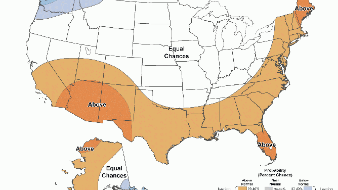
Temperature outlook 2025-26
(FOX Weather)
Much of the nation’s heartland is expected to experience near-normal conditions, while the Pacific Northwest could trend below average.
On the precipitation front, the Northern Rockies and Ohio Valley stand out as regions with the highest chances of above-average totals, while much of the rest of the country could be drier than normal.
On its face, the outlook appears to be rather straightforward but several factors make it anything but.
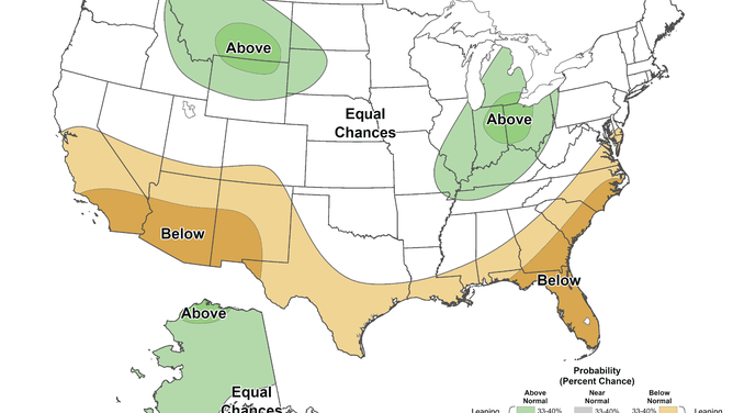
Precipitation outlook 2025-26
(NOAA)
Will a La Niña develop, and if so, how strong will it be?
Current observations across the eastern and central Pacific show water temperatures near average, meaning La Nada – or what are known as neutral ENSO conditions, are currently in control.
La Nadas typically bring fewer jet stream disruptions, resulting in a more zonal flow across the country. This pattern often keeps colder air bottled up over the northern U.S. and Canada, with warmer conditions dominating the southern states.
NOAA has long expected that the current La Nada could transition into a brief La Niña, which would likely usher in more frequent bursts of Arctic air into the country.
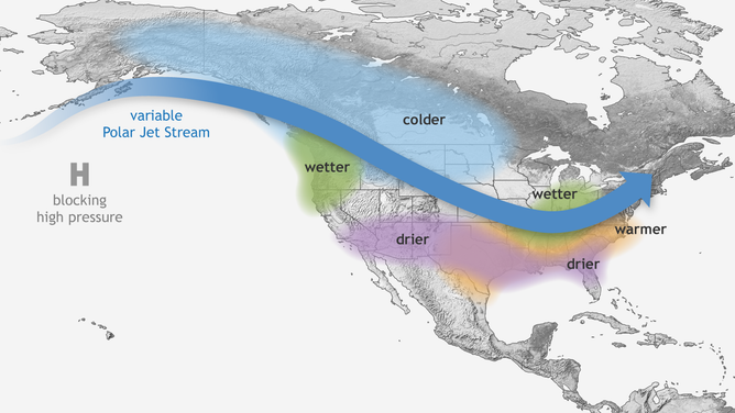
Typical wintertime impacts of La Nina across the United States.
(NOAA)
However, not all La Niñas bring colder conditions. Since 1950, roughly half of weak La Niña events have resulted in below-average winter temperatures, while the other half have featured extended warm spells.
In recent years, La Niña events have tended to lean warmer with a lack of snowfall - a possible sign of the globe's changing climate.
According to NOAA’s historical data, six of the 10 warmest winters on record have occurred within the past 24 years.
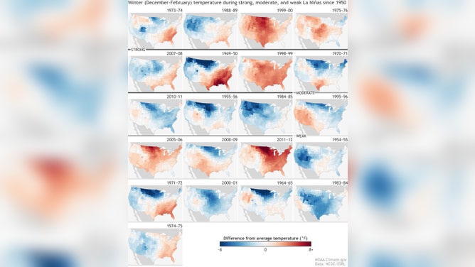
La Nina impacts since 1950.
(NOAA)
The Pacific "blob" factor
Much of the northern Pacific currently features sea surface temperatures running 5–10 degrees Fahrenheit above normal, which is setting records for both intensity and coverage.
If the "warm blob" persists into the winter months, it could have significant ramifications across North America.
During the 2013–14 winter, which also featured a prominent warm blob over the Pacific, above-average snowfall blanketed much of the central and eastern U.S., with the Midwest enduring some of the harshest conditions.
That winter was the coldest since the late 1970s and severely disrupted transportation, costing the economy billions of dollars.
![Sea surface temperatures in 2013-2014]() Image 1 of 2
Image 1 of 2Sea surface temperatures in 2013-2014 ( )
![Winter temperature departures during 2013-2014.]() Image 2 of 2
Image 2 of 2Winter temperature departures during 2013-2014. ( )


Forecasters believe the blob allowed a strong ridge to persist along the West Coast, forcing the jet stream southward across the central and eastern United States.
Initial NOAA winter outlooks do not suggest a similar setup this year, which may indicate that 2013–14 was more of an anomaly rather than a repeating pattern tied to every Pacific heat wave.
Meteorological winter officially begins on December 1 and runs through the end of February.