Widespread, significant winter storm to dump heavy snow from Central Plains to upper Midwest into the weekend
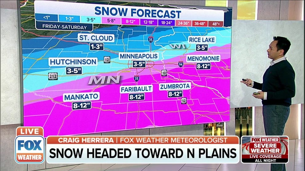
There will likely be a very sharp north-to-south gradient in snow accumulations in the Minneapolis/St. Paul metro area
Up to foot of snow possible in some areas in Central Plains, upper Midwest
Heavy snow and gusty winds will create hazardous driving conditions on Friday from southern South Dakota and northern Nebraska into northwestern Iowa and southern Minnesota, including Minneapolis/St. Paul.
A widespread and significant winter storm dumped heavy snow over the central Rockies on Thursday and will now impact the Central Plains and upper Midwest on Friday, yielding a snowy end to the week in Minneapolis/St. Paul.
The National Weather Service has issued a stripe of Winter Storm Warnings from eastern Wyoming into southern South Dakota, northern Nebraska, northern Iowa, southern Minnesota, northern and central Wisconsin and the Upper Peninsula of Michigan. Winter Weather Advisories are in effect for other parts of this region.
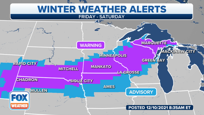
Winter weather alerts are in effect across the Central Plains, upper Midwest and northern Great Lakes.
(FOX Weather)
Additional Winter Storm Warnings and Winter Weather Advisories remain posted for parts of the central Rockies due to some lingering snow on Friday.
Denver finally received its first measurable snow of the season Friday morning, the latest occurrence of the season's first snow on record. The previous latest-in-season first snowfall for the Mile High City was Nov. 21, 1934. Denver International Airport reported 0.3 inches of snow as of 9 a.m. Mountain time on Friday.
DENVER'S NEAR-RECORD-LONG SNOWLESS STREAK ENDS
Salt Lake City also received its first measurable snow Thursday into Friday, with 1.4 inches reported at the airport as of early Friday morning.
Here is a day-by-day outlook for this winter storm.
Friday
Heavy snow and gusty winds will create hazardous driving conditions on Friday from southeastern South Dakota and northeastern Nebraska into northwestern Iowa and southern Minnesota, including the Minneapolis/St. Paul metro area. Residents in these areas are advised to plan ahead as difficult travel conditions are likely with this first significant snowstorm of the season.
Lighter snow is also expected Friday over portions of the Wyoming and Colorado Front Ranges, as well as other parts of the Northern and Central Plains and upper Midwest.

Forecast for Friday, Dec. 10, 2021.
(FOX Weather)
Friday night, snow and gusty winds will continue over portions of the upper Midwest and northern Great Lakes from eastern Nebraska and southeastern South Dakota into western and northern Iowa, southern Minnesota, northern and central Wisconsin and the Upper Peninsula of Michigan.
The heaviest snow is forecast to set up over northeastern Nebraska, northern Iowa, southern Minnesota, northern and central Wisconsin and the Upper Peninsula of Michigan.
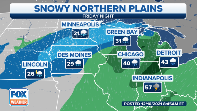
Forecast for Friday night, Dec. 10, 2021.
(FOX Weather)
Saturday
The snow will continue into Saturday in parts of Wisconsin, the Upper Peninsula of Michigan and northern Lower Michigan, though it will gradually taper to lingering snow showers and flurries through the day. Winds will also remain gusty in this region.
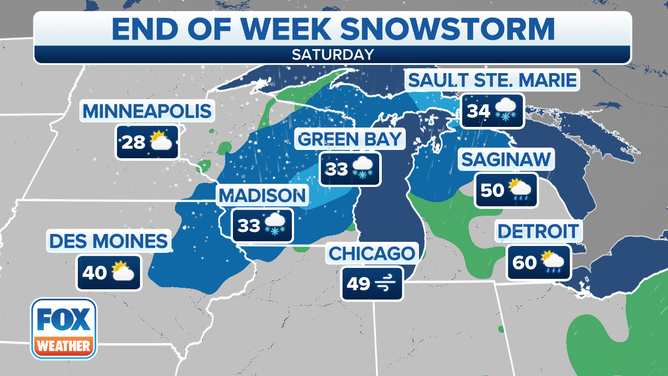
Forecast for Saturday, Dec. 11, 2021.
(FOX Weather)
How much snow?
After dumping 1 to 2 feet of snow across the highest terrain of the central Rockies, this winter storm is expected to drop a swath of 8 to 14 inches of snow from southeastern South Dakota through a stripe of the upper Midwest into the Upper Peninsula of Michigan.
There will likely be a very sharp north-to-south gradient in snow accumulations across this region, ranging from an inch or two to more than 8 inches over a short distance. That might cause significant variability in snowfall amounts in the Minneapolis/St. Paul metro area, with significantly higher totals near or just south of the Twin Cities versus areas to the north.
Snowfall rates could reach 2 inches per hour at times, and when combined with strong winds, it will lead to very difficult travel conditions with slick, snow-covered roads and near-whiteout conditions. There may also be a few power outages due to the weight of the heavy snow on trees and power lines.
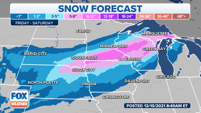
Snow forecast through Saturday, Dec. 11, 2021.
(FOX Weather)
The warm side of this storm system is expected to produce severe thunderstorms, including the potential for tornadoes, Friday night in parts of the mid-South and Ohio Valley.
Check back with FOX Weather for updates on both the snowy and warmer sides of the storm.