When to expect worst from Hurricane Erin on East Coast: A state-by-state breakdown
Erin passed offshore of North Carolina on Wednesday night and into Thursday morning, bringing the biggest impacts to the Outer Banks.

Maryland beaches walloped by strong winds and surf from Hurricane Erin
Beaches in Ocean City, Maryland, are closed as Hurricane Erin creates dangerous surf conditions offshore. FOx Weather Correspondent Brandy Campbell is on the beach where 40 mph winds and 10-foot waves were recorded Thursday morning.
Hurricane Erin’s impacts are already underway across the Southeast and throughout the Northeast, where many beaches are closed to all but the most experienced surfers.
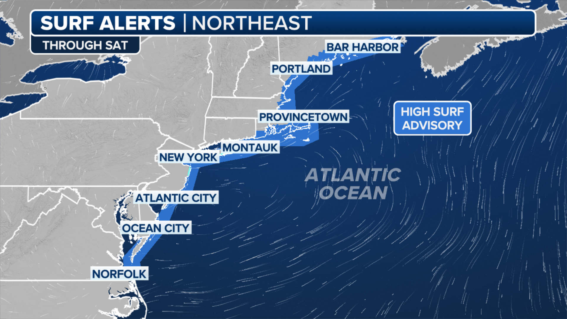
Here’s a breakdown of when those on the East Coast, from the Carolinas to Maine, will see inclement coastal conditions as Hurricane Erin continues northeastward off the U.S. coastline this week.
North Carolina: Ongoing coastal flooding, wind and surf
(FOX Weather)
Erin passed offshore of North Carolina on Wednesday night and into Thursday morning, bringing the biggest impacts to the Outer Banks.
North Carolina Gov. Josh Stein has declared a state of emergency to assist with the response to Hurricane Erin and to mobilize resources.
![North Carolina Highway 12 Closed]() Image 1 of 10
Image 1 of 10Heavy surf and storm surge from Hurricane Erin shut down North Carolina's Highway 12 on Aug. 20, 2025. (NC Dept. of Transportation)
![North Carolina Highway 12 Closed]() Image 2 of 10
Image 2 of 10Heavy surf and storm surge from Hurricane Erin shut down North Carolina's Highway 12 on Aug. 20, 2025. (NC Dept. of Transportation)
![NC Flooding]() Image 3 of 10
Image 3 of 10Storm surge floods a hotel in Buxton, N.C. as Hurricane Erin swirls offshore on Aug. 20, 2025. (Mark Sudduth)
![Beach life mostly returned to normal on Isle of Palms, South Carolina on Thursday, Aug. 21, 2025 after Hurricane Erin passed the Carolina coast.]() Image 4 of 10
Image 4 of 10Beach life mostly returned to normal on Isle of Palms, South Carolina on Thursday, Aug. 21, 2025 after Hurricane Erin passed the Carolina coast. (Robert Ray)
![Beach life mostly returned to normal on Isle of Palms, South Carolina on Thursday, Aug. 21, 2025 after Hurricane Erin passed the Carolina coast.]() Image 5 of 10
Image 5 of 10Beach life mostly returned to normal on Isle of Palms, South Carolina on Thursday, Aug. 21, 2025 after Hurricane Erin passed the Carolina coast. ( )
![Beach life mostly returned to normal on Isle of Palms, South Carolina on Thursday, Aug. 21, 2025 after Hurricane Erin passed the Carolina coast.]() Image 6 of 10
Image 6 of 10Beach life mostly returned to normal on Isle of Palms, South Carolina on Thursday, Aug. 21, 2025 after Hurricane Erin passed the Carolina coast. ( )
![Beach life mostly returned to normal on Isle of Palms, South Carolina on Thursday, Aug. 21, 2025 after Hurricane Erin passed the Carolina coast.]() Image 7 of 10
Image 7 of 10Beach life mostly returned to normal on Isle of Palms, South Carolina on Thursday, Aug. 21, 2025 after Hurricane Erin passed the Carolina coast. (Robert Ray)
![Beach life mostly returned to normal on Isle of Palms, South Carolina on Thursday, Aug. 21, 2025 after Hurricane Erin passed the Carolina coast.]() Image 8 of 10
Image 8 of 10Beach life mostly returned to normal on Isle of Palms, South Carolina on Thursday, Aug. 21, 2025 after Hurricane Erin passed the Carolina coast. (Robert Ray)
![Beach life mostly returned to normal on Isle of Palms, South Carolina on Thursday, Aug. 21, 2025 after Hurricane Erin passed the Carolina coast.]() Image 9 of 10
Image 9 of 10Beach life mostly returned to normal on Isle of Palms, South Carolina on Thursday, Aug. 21, 2025 after Hurricane Erin passed the Carolina coast. (Robert Ray)
![Ocean swells creep up the beach in Kitty Hawk, North Carolina, during Thursday Morning's high tide.]() Image 10 of 10
Image 10 of 10Ocean swells creep up the beach in Kitty Hawk, North Carolina, during Thursday Morning's high tide. (FOX Weather Storm Specialist Mike Seidel)


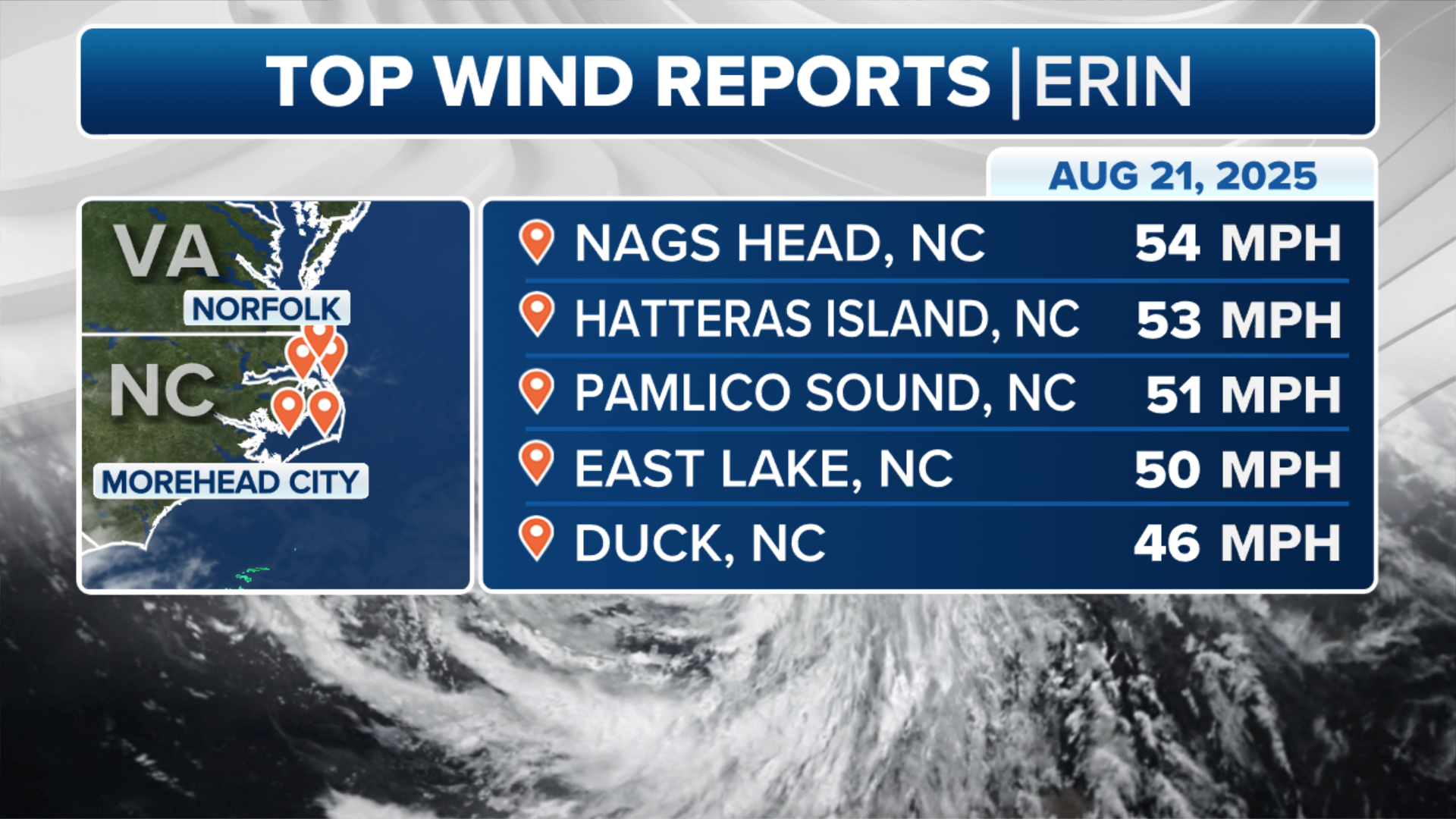
Strong winds and big waves are ongoing along the Outer Banks throughout the day. Winds in Nags Head and Hatteras Island topped 50 mph on Thursday morning.
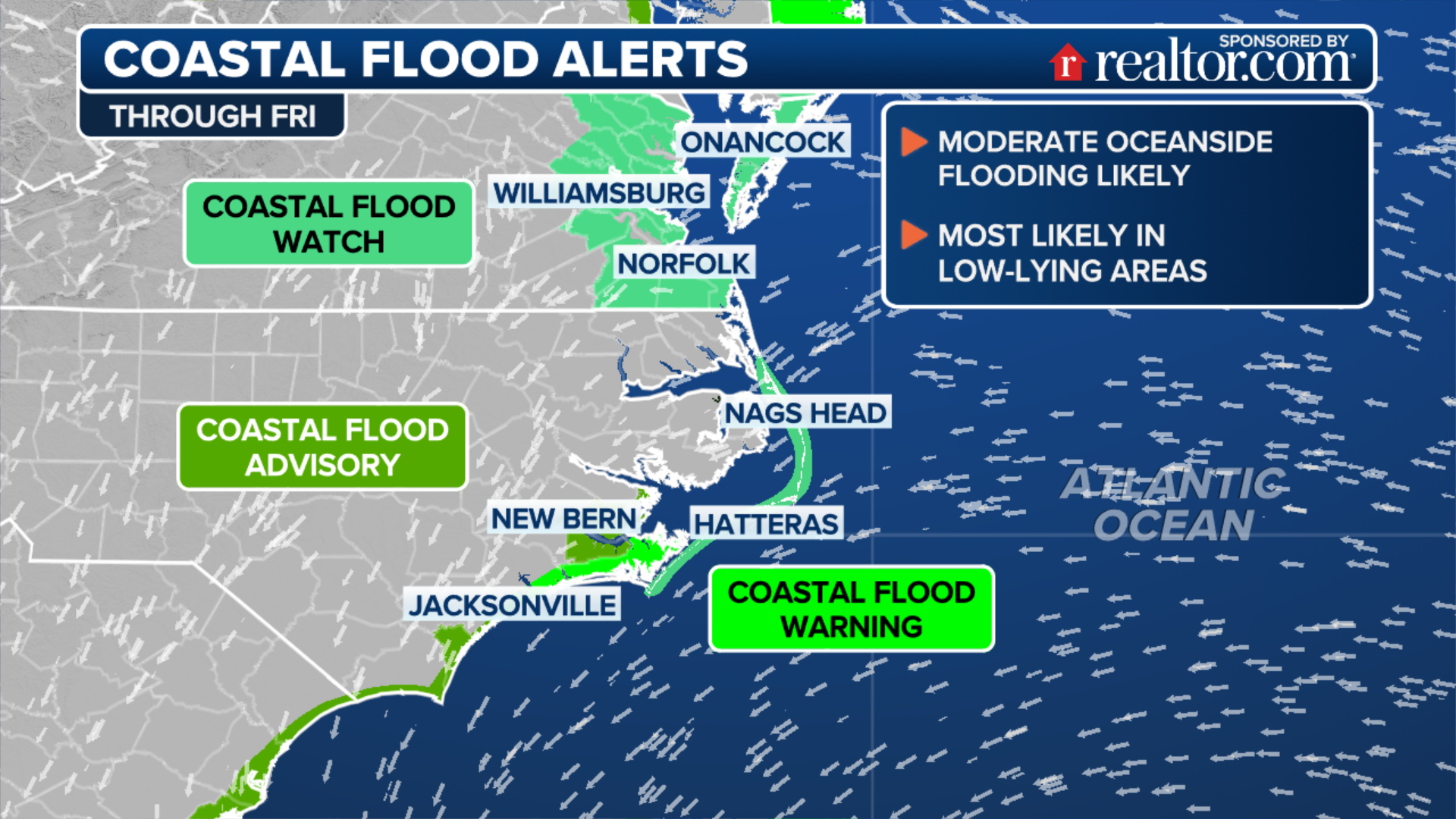
Coastal flood alerts are in place for much of the Southeast, including a warning for the Outer Banks.
(FOX Weather)
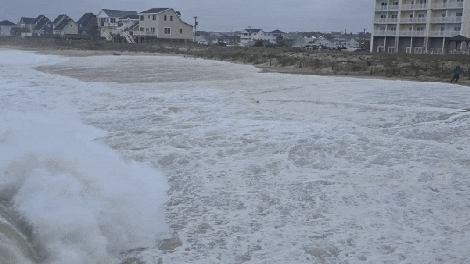
Large waves are ongoing, and beaches across the coast are closed. Waves are forecast to reach up to 20 feet, with the swell lasting into Friday with 10-foot waves and dangerous rip currents.
Virginia and Maryland: Continuing Thursday
Peak impacts from Erin started late Wednesday and lasted into Thursday morning for coastal Virginia, where a Tropical Storm Warning remains in effect.

Hurricane Erin produces large swells during surfing championship on Virginia coast
The 63rd annual Coastal Edge East Coast Surfing Championships are underway in Virginia Beach as Hurricane Erin produces rough weather and waves. Lindsey Peard, Jessie Cox and Tony Pellino with ECSC spoke about the measures they are taking to keep the athletes safe.
Large waves, strong rip currents, coastal flooding and strong winds are all possible along the coast. Gusty winds of up to 40 mph are possible on Thursday.
(FOX Weather)
Erin will continue north on Thursday, making its closest approach to the Maryland coast but still remaining well offshore.
New Jersey and Delaware: Thursday-Friday
Throughout Thursday, New Jersey and Delaware beaches are seeing the most significant coastal hazards with large breaking waves, gusty winds and life-threatening rip currents.

Cat 2 Hurricane Erin brings swell for New Jersey, New York surfers
FOX Weather Meteorologist Jane Minar is in Long Beach, New York where experienced surfers are welcoming the waves created by Hurricane Erin. She spokes to Long Beach Chief Lifeguard Rich Borawaski who explained the surf rules for those hoping to ride these waves.
"While the center of the storm will pass about 350-450 miles south and east of our area, it will be rapidly expanding in size with its tropical-storm-force wind field reaching just offshore of our coasts," the NWS in Mount Holly, New Jersey, said.
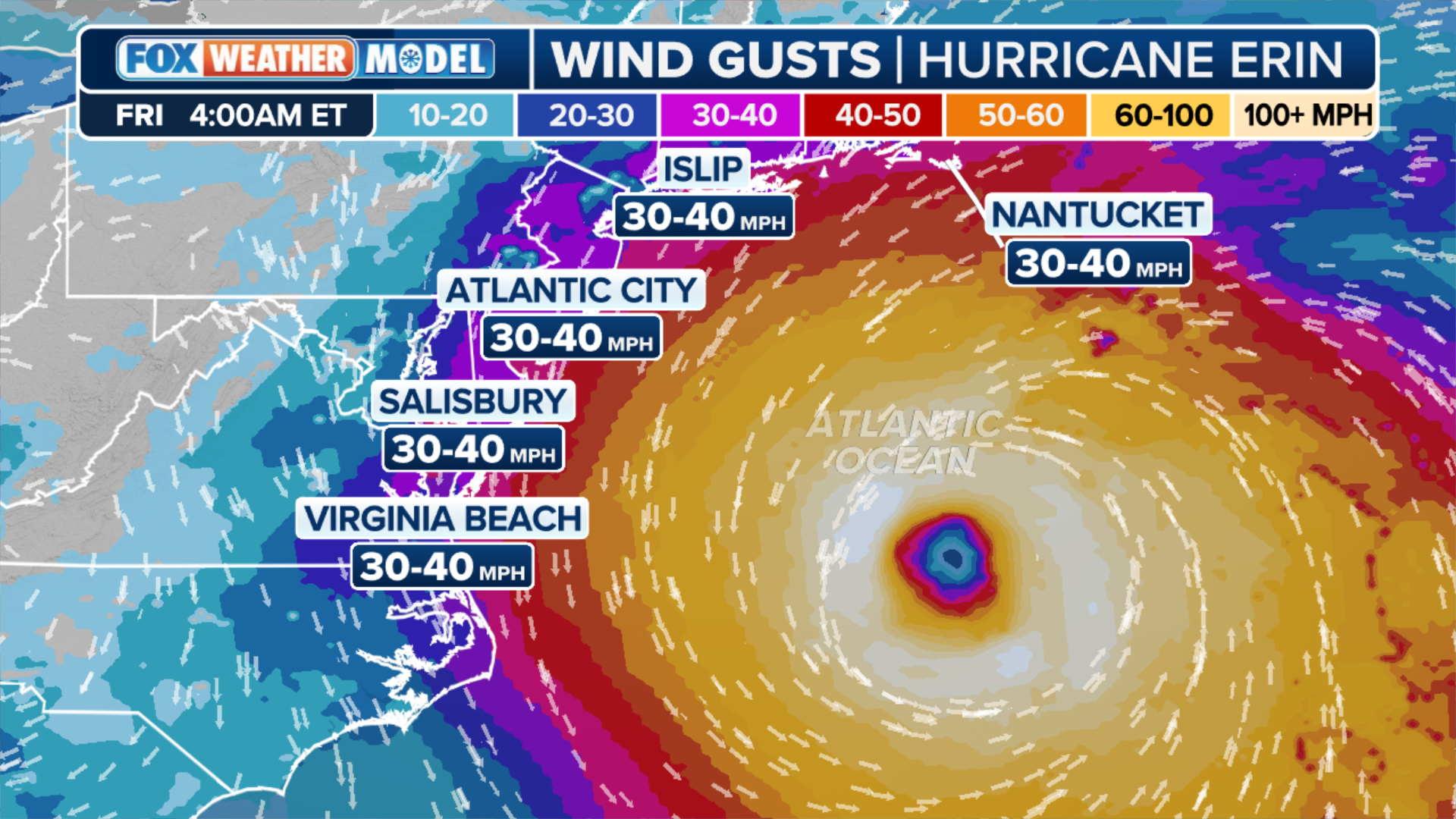
A Wind Advisory is in place from Thursday morning through Thursday night from Ocean County southward, where sustained winds of up to 30 mph could last for more than two hours.
On Friday, the weather will clear up, but the dangerous surf and rip currents will remain.
New York: Thursday night-Friday morning
(FOX Weather)
From Thursday through Friday night, Erin will pass southeast of New York.
Winds will peak between late Thursday and early Friday, with localized gusts of up to 40 mph across Long Island and the coast.
Massachusetts and Rhode Island: Friday
Erin will pass well offshore of New England on Friday, where a High Surf Advisory is in place for coastal areas. Large, breaking waves began increasing on Wednesday and will peak on Friday, with waves up to 13 feet in the surf zone.

Erin produces large waves, pummeling Eastern U.S. Coast
Large waves from Hurricane Erin have been slamming the East Coast this week. Here are some of the wildest shots of those waves along the Atlantic shoreline.
High surf, dangerous rip currents and gale-force gusts, along with beach erosion, will be the primary threats through Friday.
Maine: Ongoing waves through Friday
The primary threats from Erin in Maine will be offshore with waves up to 9 feet along the coast. Rip currents and coastal erosion are also possible through the weekend.