Severe storms rip through Texas as heavy rain threat scrambles New Orleans Mardi Gras parade schedules
Moisture from an atmospheric river that soaked California earlier this week is moving into Texas and the Gulf Coast, presenting a severe weather and flood threat. Included in the increased flood threat are Baton Rouge and New Orleans, where months-long Mardi Gras celebrations are already underway.
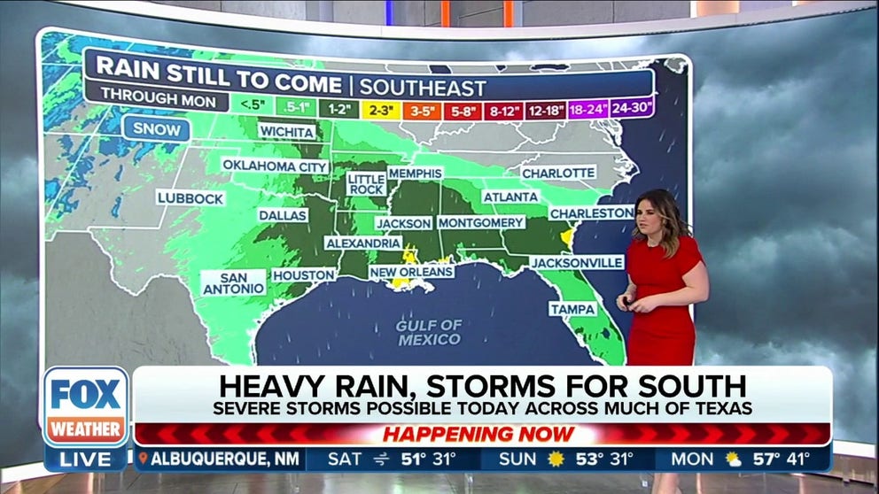
South faces flood risk through weekend
Heavy rainfall will push along the Interstate 10 corridor over the weekend. Some 2-3" of rainfall could fall around New Orleans and Savannah, Georgia.
NEW ORLEANS – A storm system that drenched the Pacific Northwest and California on Thursday and triggered a few tornadoes in Texas Friday is now moving through the Southeast with heavy rainfall and thunderstorms.
Luckily, due to less instability around the Gulf Coast over the weekend, fewer severe storms are expected as the weather system moves along the Gulf Coast, but heavy rainfall can cause problems, especially for ongoing Mardi Gras festivities.

(FOX Weather)
At least two tornadoes were spotted by storm chasers in Texas on Friday. The twisters are only thought to have been on the ground for a few minutes, but that did not stop chasers like Hailey Jo from capturing one of them on video as it passed through Sagerton, Texas.
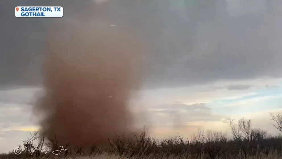
Tornado rolls through Sagerton, Texas, on Friday evening
A tornado was briefly on the ground in Sagerton, Texas, on Friday evening. There were no initial reports of damage from the twister.
At least one additional tornado was spotted outside of Haskell, Texas.
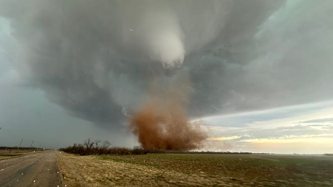
A supercell produced at least one tornado in Hamlin, Texas.
(@BrianAllenWX / FOX Weather)
In both instances, there were no reports of any widespread damage or injuries.
The SPC also received several reports of quarter-sized hail and wind gusts of 60 mph, including a gust of 64 mph in Cottle, Texas and a 59 mph gust just outside Houston.
Heavy rains trigger flooding threat, adjusted Mardi Gras parade schedules
NOAA’s Weather Prediction Center has highlighted parts of southeastern Texas, Arkansas, Louisiana and Mississippi as being at an increased risk for excessive rainfall and flooding.
That area includes Baton Rouge and New Orleans on Saturday, where month-long Mardi Gras celebrations are underway.
More than two dozen Mardi Gras parades are scheduled Friday through Sunday in New Orleans, and those on Saturday into the late evening are likely to be wet, with 1-2 inches of rain predicted amid 35 mph wind gusts. In fact, some parades have had to adjust their schedules.
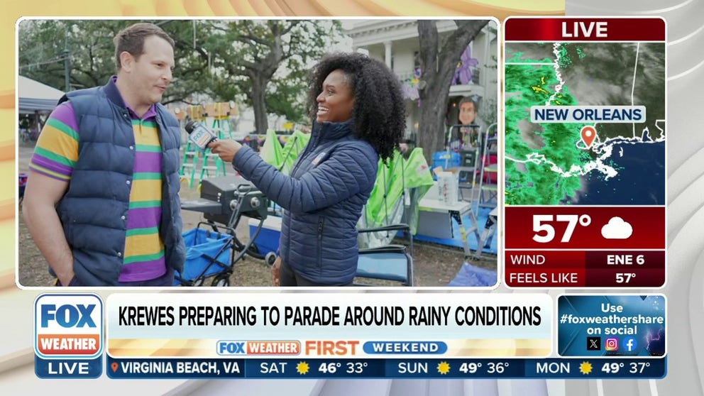
"It forced five krewes on the New Orleans route to start rolling two hours earlier, with the sixth krewe actually delaying until Sunday," FOX Weather Meteorologist Brandy Campbell reported from New Orleans on Friday. "Working with the New Orleans Police Department, crews decided to reduce bands and other marching elements within their krewes."

(FOX Weather)
About 15 minutes away in Metairie, Louisiana, the Magical Krewe of Mad Hatter's was the only parade scheduled on Saturday. But now they're going to roll on Sunday behind the Atlas Parade after learning from meteorologists they would have gotten hammered by the weather if they did not move the parade.
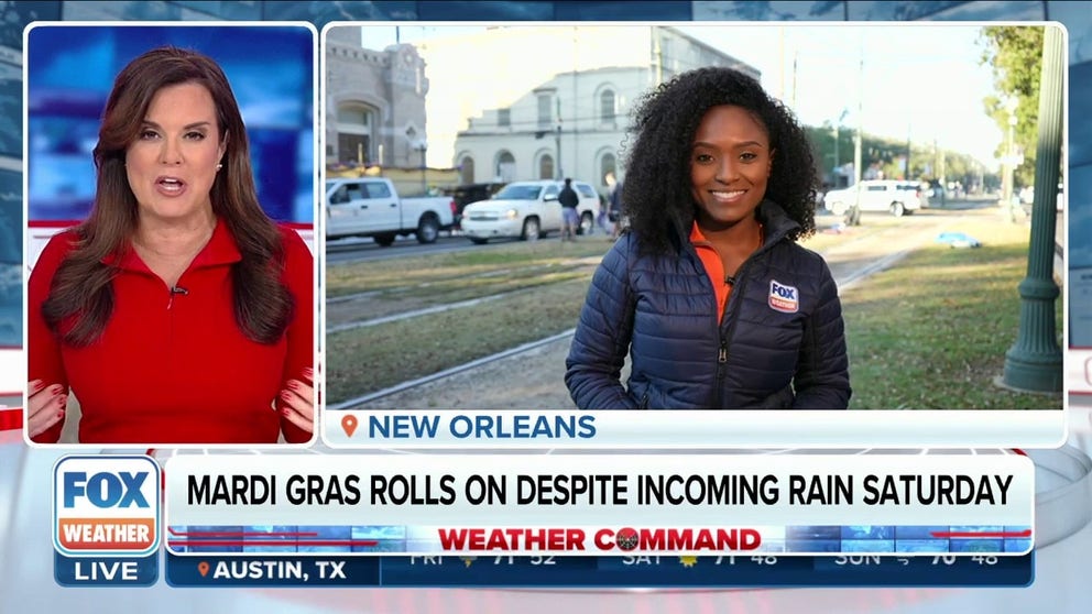
Mardi Gras in New Orleans rolls on despite incoming rain Saturday
Heavy rainfall impacting the West is set to transition into the Southeast over the next few days. NOAA’s Weather Prediction Center has highlighted parts of Texas, Arkansas, Louisiana and Mississippi for being at an increased risk for excessive rainfall and flooding. Active El Nino patterns are known to produce heavy rainfall events over the South.
"You see thunderstorms sitting on your parade, it's the most empty feeling that you can have," Joey LaCoste of Magical Krewe of Mad Hatters told FOX Weather. "You know, your heart goes to your feet. So we were real concerned. And there's a safety issue here because we have large floats that would attract lightning. And nobody wants to be sitting in a thunderstorm watching a parade."
BLOWTORCH WEATHER TO CONTINUE DURING FINAL FULL MONTH OF WINTER, NOAA SAYS
How much rain will fall?
Forecast models show a widespread 1-2 inches of rainfall across the South, with some communities seeing potentially upwards of 3-4 inches. Some counties in Mississippi have already been put under a Flash Flood Watch.
Some major Mardi Gras parades undergo schedule changes as rainy conditions loom this weekend
Mardi Gras season has arrived, and major parades are scheduled for the next two weekends. Unfortunately, rain is in the forecast, causing crews to scramble and adjust plans to work around the storm. FOX Weather’s Brandy Campbell is in New Orleans to learn more about how the krewes are preparing for the inclement weather.
More than a dozen river gauges across the Lower Mississippi River Valley are already in flood stage leftover from January’s heavy rainfall.

(FOX Weather)
Several storm systems have traveled over the region during the last three weeks, which have dropped between 1-2 feet of rainfall.
The beneficial rains have cut down on areas suffering from extreme and exceptional drought conditions by more than half, but 88% of Louisiana and 84% of Mississippi are still unusually dry.
By Tuesday morning, the entire storm system is expected to be off the East Coast, but with an active southern jet during an El Niño pattern, more chances of precipitation are expected to impact the Gulf Coast.
NORTHEAST, MIDWEST TO SEE SUNNY WEEKEND AFTER WEEK OF RELENTLESS GLOOM