Warmer-than-average winter predicted for most of US, NOAA says
Meanwhile, the Pacific Northwest is predicted to have a colder-than-average winter
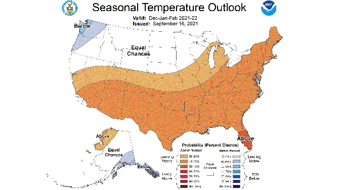
Winter temperature outlook for December 2021 through February 2022 issued by NOAA's Climate Prediction Center on Sept. 16, 2021.
(NOAA's Climate Prediction Center)
Most of the United States could have a relatively mild winter in 2021-22, according to a seasonal temperature outlook issued Thursday by NOAA.
Areas from the Northeast to the Ohio Valley, Deep South, Desert Southwest and Southern California have a 40 to 50% chance of above-average temperatures from December through February, which means NOAA is leaning toward a warmer-than-average winter in those regions.
Those odds drop slightly to 33 to 40% from the upper Great Lakes to the mid-Mississippi Valley, Central Plains, Great Basin and Central California, which means confidence of above-average temperatures is just a little lower there.
NOAA's forecasters have the highest confidence that Central and South Florida will have a warm winter compared to average, indicating a 50 to 60% chance of above-average temperatures in those regions of the Sunshine State.
Meanwhile, the Pacific Northwest is predicted to have a colder-than-average winter. The odds of below-average temperatures have been placed at 40 to 50% from western Washington into northwestern Oregon and 33 to 40% from most of the rest of Washington into western Oregon.
Areas from Northern California to the northern Rockies, Northern Plains and upper Mississippi Valley have equal chances of above- and below-average temperatures this winter, according to NOAA's outlook, which means it could swing either way.
Keep in mind that this early outlook for the upcoming winter only shows the overall pattern that's expected over the three-month period from December through February. An individual cold front or an upper-level area of high pressure can bring a period of colder or warmer temperatures, respectively, that differs from the overall three-month outlook.
It's also important to note that a forecast of above-average temperatures during the winter doesn't necessarily mean it will be a "warm" winter.
For example, the average high in Chicago in mid- to late January is only 31 degrees. That means even a high temperature of 35 or 40 degrees would be considered warmer than average, but it's certainly not a "warm" day.
La Niña expected to play a role
NOAA's Climate Prediction Center noted in its long-range discussion that impacts from a potential La Niña become quite apparent this winter, as above-average temperatures are favored across the southern U.S. and the Eastern Seaboard while below-average temperatures are forecast across the Northwest.
This temperature pattern is very typical of a wintertime La Niña, which is given a 70 to 80% chance of being in charge this winter.
La Niña is part of a 5- to 7-year cycle known as ENSO, or El Niño Southern Oscillation, that is generated from a change in water temperatures in the central equatorial Pacific Ocean.
When the waters in this region cool to 0.5 degrees Celsius below average, it's considered La Niña, while warming to 0.5 degrees Celsius above average is known as El Niño. When water temperatures are between 0.5 degrees Celsius above and below average, it's called "neutral" conditions.
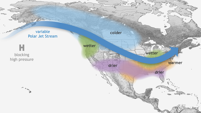
Typical wintertime impacts of La Niña in the United States.
(NOAA)