La Nina now given nearly 80% chance of being in charge this winter
It's looking more and more likely we're about to go through a second winter with La Niña in charge, according to updated forecasts on the El Niño/La Niña cycle.
WASHINGTON -- It's looking more and more likely we're about to go through a second winter with La Niña in charge, according to updated forecasts on the El Niño/La Niña cycle.
It's not quite a slam dunk, but perhaps a short layup? Free throw?
There is now a predicted 78-79% chance that La Niña conditions will be present by mid-autumn, with a 63-73% chance it arrives even earlier. That's a considerable rise from their previous forecast last month that was shading closer to 50/50 odds of La Nina versus a "neutral" winter where neither La Niña nor El Niño conditions are present.
So far, indications are that if La Niña arrives, it will be a weak La Niña event.
What is La Niña?
La Niña is part of a 5-7 year cycle known as ENSO, or El Nino Southern Oscillation, that is generated from a change in water temperatures in the central Pacific Ocean. When the waters cool below 0.5 degrees C of normal, it's considered La Niña, while being warmer than 0.5 degrees C is known as El Niño. When it's in between, it's called "neutral" conditions.
Researchers have found these changes in ocean temperatures have a cascading effect on weather conditions across the tropics in the Pacific Ocean, which in turn has a profound effect on global weather patterns by altering jet stream patterns.
In the United States, La Niña winters generally bring cooler, wetter conditions to the north and milder and drier conditions to the south. It can keep a drought going in the Southwest while the Pacific Northwest basks in an above average mountain snowpack. The upper northern plains are usually in for a colder winter (more than the typical cold) while the Great Lakes region also tends to lean on the wetter side. The southeast and Deep South west into Texas usually end up with a mild and dry winter.
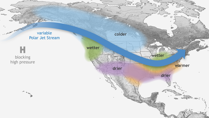
Wintertime impacts of La Nina
(NOAA)
(As you might surmise, the opposite part of the cycle, the warm phase "El Niño" conditions, tend to bring the reverse patterns. El Niño winters are usually warm and mild across the northern U.S. and very wet across the South.)
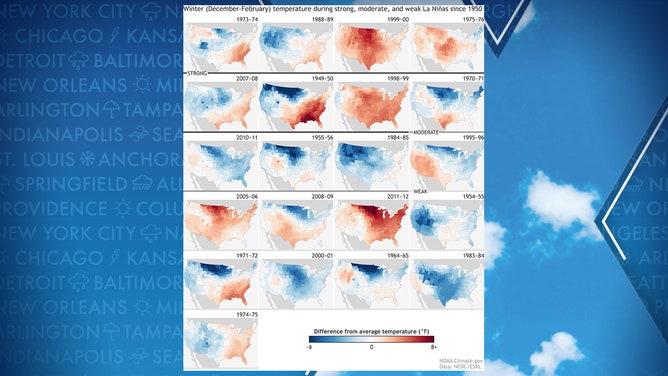
La Nina Maps since 1950
Globally, La Niña winters can cause drought in South America, affect the monsoon season in the Indian Ocean and supercharge the Atlantic Hurricane season. Last year's record hurricane season coincided with a La Niña winter.
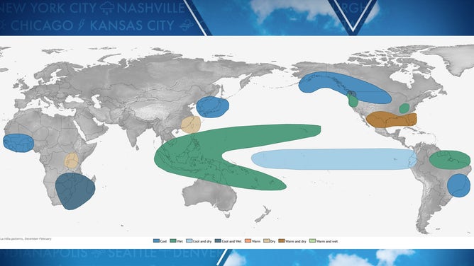
Typical global impacts of La Nina
(NOAA)
Hey, that's right: Didn't we just do this last winter?
Indeed, this is shaping up to what forecasters call a "Double Dip" La Nina where we warm out of La Niña conditions after a winter, then return to La Niña in time for the next winter.
Traditionally we think of the ENSO cycle progressing over a 5-7 year period from El Niño to neutral to La Niña winters, then reverse back through neutral to another El Niño winter and staring the cycle over.
But sometimes La Niña decides go give it a second go, and in fact, of the past 12 La Nina winters, eight have featured a Double Dip!
When do we declare La Niña here?
As of early September, ocean temperatures were just on the fringe of La Niña at 0.3 degrees Celsius below average, just shy of the half degree threshold.
Forecasters have maintained a "La Niña Watch" since the summer indicating that La Nina conditions are possible. But if ocean temperatures drop below the half degree threshold and there are signs the atmosphere in the tropics is reacting to the cooler ocean, forecasters will issue a "La Niña Advisory" stating La Nina conditions are now present.
It's expected if La Niña is here this winter, that it would gradually fade into the spring, leaving us with likely neutral conditions into the winter of 2022-23. If the cycle holds we would expect our next El Niño winter in 2023 or 2024.