See what communities looked like before and after May’s tornado outbreak from aerial imagery
May is typically the peak month for tornadoes in the U.S., with between 250-300 formations. The tornado that struck Barnsdall, Oklahoma, was given the preliminary rating of an EF-4 after dozens of homes were damaged or destroyed. The tornado that impacted Portage, Michigan, was given a preliminary rating of an EF-2 and was on the ground for at least 11 miles.

How a museum in Michigan is working to clean-up from an EF-2 tornado
Dozens of buildings were damaged and destroyed in Portage in Kalamazoo County, Michigan, during severe weather.
Hours after an outbreak of severe weather impacted dozens of states, experts in the field of geospatial data were busy surveying neighborhoods in Barnsdall, Oklahoma, and Portage, Michigan – both impacted by tornadoes.
Geospatial Insurance Consortium released aerial imagery of what the communities looked like before and after the tornadoes struck, and photos show the erratic characteristics of one of Mother Nature’s most powerful forces.
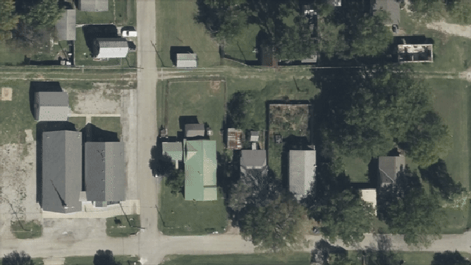
Imagery from Barnsdall, Oklahoma, showed homes and outbuildings that had significant storm damage, with debris spread many yards from the residences.
Imagery from Barnsdall, Oklahoma showed homes and outbuildings that had significant storm damage, with debris spread many yards from the residences.
(Geospatial Insurance Consortium / FOX Weather)
Many trees appeared to be de-leafed or even snapped at their bases.
Meteorologists at the National Weather Service office in Tulsa determined that the tornado that struck the community maxed out an EF-4 strength with winds around 166-200 mph.
Local authorities reported more than three dozen homes were either damaged or destroyed, and one person was killed.
SCAR OF DEVASTATING OKLAHOMA EF-4 TORNADO CAN BE SEEN FROM SPACE
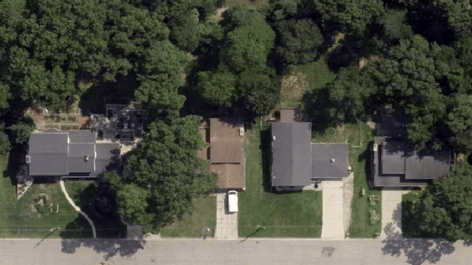
The same storm system produced tornadoes in Michigan, with an EF-2 tearing a path through the town of Portage in Kalamazoo County.
Local meteorologists determined the twister to have winds in the 111-135 mph range, but due to the more densely populated area, more structures were damaged or destroyed than during northeastern Oklahoma's event.
"The high-resolution oblique and ortho imagery shows widespread devastation and the erratic nature of a tornado, where one home could be left standing and the two or three next to it completely destroyed," the GIC said.
Portage in Kalamazoo County, Michigan
(Geospatial Insurance Consortium / FOX Weather)
WHY TORNADO ALLEY IS SHIFTING EAST
Photos showed extensive roof damage to homes, and unlike trees and foliage in Oklahoma, the vegetation appeared to be uprooted versus being snapped by the strong winds.
The differences in the characteristics of the damage may be due to the weaker wind speeds or because the ground in parts of the Great Lakes is a bit more saturated than in the Plains.
The before-and-after imagery is provided to insurers to help the claim processes in disaster zones.
"This imagery helps our insurer members proactively reach out to impacted customers to get them on the road to recovery as quickly as possible," the GIC stated.
Damage estimates from the latest round of severe storms have not been released, but an outbreak during the final days of April is estimated to have produced losses in excess of $2 billion.
May is typically the peak month for tornadoes in the U.S., with 250-300 typical formations.
During June and July, the storm track tends to shift northward, with states such as the Dakotas, Minnesota and Iowa being at a higher risk for severe weather.
Imagery from Barnsdall, Oklahoma showed homes and outbuildings that had significant storm damage, with debris spread many yards from the residences.
(Geospatial Insurance Consortium / FOX Weather)