Scar of devastating Oklahoma EF-4 tornado can be seen from space
The tornado scar is so immense from the EF-4 Oklahoma tornado that a satellite almost 500 miles up caught it.

Aerial video shows devastation in Barnsdall, Oklahoma, after deadly tornado
Residents in communities across the central U.S. are once again sifting through the debris of destroyed homes and businesses after severe weather and tornadoes ripped across the region from Monday night into Tuesday morning, leaving at least one person dead and causing catastrophic damage in a city north of Tulsa in Oklahoma.
BARNSDALL, Okla. – The EF-4 tornado that destroyed much of Bartlesville and Barndsall, Oklahoma on Sunday, left a scar so large that it could be seen by satellites.
NWS survey teams calculated the path to be 39.1 miles long and at one point, it was almost a mile wide. A European Space Agency satellite captured this image on May 5, the day after the deadly tornado.
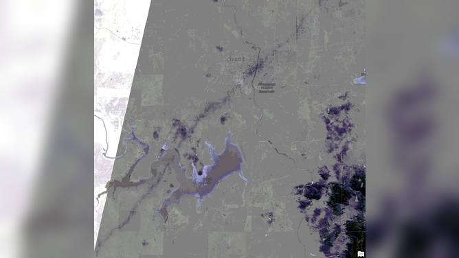
This enhanced satellite image from May 6, the day after the tornado, shows the tornado's path in darker purple/gray running from lower left to upper right.
(European Space Agency / FOX Weather)
The enhanced satellite image clearly shows the disturbed path from lower left to upper right.

This satellite image from May 6, the day after the tornado shows the tornado's path in darker purple/grey running from lower left to upper right.
(European Space Agency / FOX Weather)
The sun-synchronous satellite sits about 488 miles above the surface of the Earth.
Even the true color satellite image shows the path, although it is harder to see.

This satellite image from May 6, the day after the tornado shows the tornado's path in darker purple/grey running from lower left to upper right.
Look for the brown line through the vegetation southwest of the lake as it crosses the western branch. You can pick it up again northeast of the white patch of clouds. It churns up more dirt through the Osage Reservation before hitting the southeast side of Barnsdall.
The debris path gets lighter as it picks up and scatters the lumber, insulation and siding that were homes the day before.
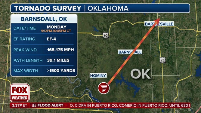
The path of the tornado.
(FOX Weather)
FAMILY ESCAPES HOME MINUTES BEFORE OKLAHOMA TORNADO WIPED IT OUT: ‘WE WERE TERRIFIED’
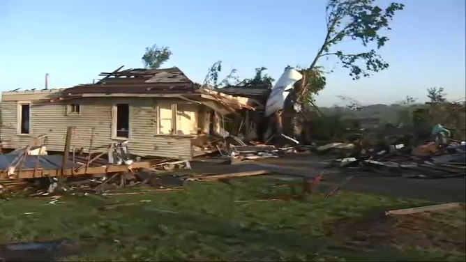
This is what the tornado looked like from the ground:

Watch: Tornado rips through Barndsall, leaving behind wake of damage in Oklahoma
A tornado ripped through Barndsall Oklahoma, on Monday evening, leaving behind a wake of damage.
The NWS issued a Tornado Emergency, the most dire of tornado alerts, for Osage County in Oklahoma on Monday evening as the storm approached. The NWS referred to a "large and destructive tornado" moving toward Barnsdall and causing catastrophic damage.
TOWNS REELING ACROSS CENTRAL US AFTER ANOTHER ROUND OF DEADLY SEVERE WEATHER DECIMATES TOWNS
"We have a big area of total destruction," Osage County Emergency Management Director Jerry Roberts told FOX Weather.
![Tornado damage in Barnsdall, Oklahoma]() Image 1 of 13
Image 1 of 13Damage left after a tornado swept through Barnsdall, Oklahoma on May 6, 2024. (Robert Ray)
![Tornado damage in Barnsdall, Oklahoma]() Image 2 of 13
Image 2 of 13Damage left after a tornado swept through Barnsdall, Oklahoma on May 6, 2024. (Robert Ray)
![Tornado damage in Barnsdall, Oklahoma]() Image 3 of 13
Image 3 of 13Damage left after a tornado swept through Barnsdall, Oklahoma on May 6, 2024. (Robert Ray)
![Tornado damage in Barnsdall, Oklahoma]() Image 4 of 13
Image 4 of 13Damage left after a tornado swept through Barnsdall, Oklahoma on May 6, 2024. (Robert Ray)
![Tornado damage in Barnsdall, Oklahoma]() Image 5 of 13
Image 5 of 13Damage left after a tornado swept through Barnsdall, Oklahoma on May 6, 2024. (Robert Ray)
![Tornado damage in Barnsdall, Oklahoma]() Image 6 of 13
Image 6 of 13Damage left after a tornado swept through Barnsdall, Oklahoma on May 6, 2024. (Robert Ray)
![Tornado damage in Barnsdall, Oklahoma]() Image 7 of 13
Image 7 of 13Damage left after a tornado swept through Barnsdall, Oklahoma on May 6, 2024. (Robert Ray)
![Tornado damage in Barnsdall, Oklahoma]() Image 8 of 13
Image 8 of 13Damage left after a tornado swept through Barnsdall, Oklahoma on May 6, 2024. (Robert Ray)
![Tornado damage in Barnsdall, Oklahoma]() Image 9 of 13
Image 9 of 13Damage left after a tornado swept through Barnsdall, Oklahoma on May 6, 2024. (Robert Ray)
![Tornado damage in Barnsdall, Oklahoma]() Image 10 of 13
Image 10 of 13Damage left after a tornado swept through Barnsdall, Oklahoma on May 6, 2024. (Robert Ray)
![Tornado damage in Barnsdall, Oklahoma]() Image 11 of 13
Image 11 of 13Damage left after a tornado swept through Barnsdall, Oklahoma on May 6, 2024. (Robert Ray)
![Significant damage is seen in Barnsdall, Oklahoma, on Tuesday, May 7, 2024, after a tornado struck the city overnight.]() Image 12 of 13
Image 12 of 13Significant damage is seen in Barnsdall, Oklahoma, on Tuesday, May 7, 2024, after a tornado struck the city overnight. (KOKI)
![Tornado damage in Barnsdall, Oklahoma]() Image 13 of 13
Image 13 of 13Damage left after a tornado swept through Barnsdall, Oklahoma on May 6, 2024. (Robert Ray)


One person died and eight more were injured. In Barnsdall alone, 40 homes were damaged. The town water system was destroyed. Utilities are just now getting the upper hand in capping gas leaks and repairing power poles.