Three rounds of winter storms kick off this weekend, targeting millions in Midwest, Northeast with snow, ice
Due to complex atmospheric dynamics, exactly how much snow and ice will fall and where still remain something of an open question. But even at the highest end projections, these storms will not be as impactful as the historic blizzard that slammed the Interstate 95 corridor earlier this week.

Three rounds of winter weather target Midwest to New England
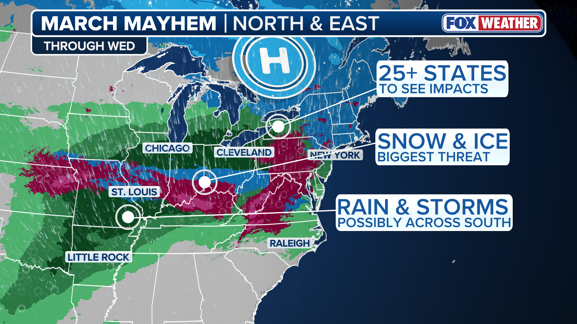
Snow and ice are in the forecast for areas of the Midwest, Northeast and Mid-Atlantic as multiple rounds of winter weather are expected to sweep the regions through the middle of next week. The multiday event is expected to impact 25 states from Montana to Massachusetts. FOX Weather Meteorologist Melanie Black has you covered with the latest forecast:
Millions of people across 25 states in the winter-weary Midwest and Northeast face three different winter storms that are set to bring more snow and dangerous ice starting this weekend. The weather setup of each storm is different, reflecting an ongoing battle between lingering cold air digging south from Canada and warmer air from the Gulf being pulled north, as the calendar flips to March.
Due to these complex atmospheric dynamics, exactly how much snow and ice will fall and where still remain something of an open question. But even at the highest end projections, these storms will not be as impactful as the historic blizzard that slammed the Interstate 95 corridor earlier this week.
(FOX Weather)
First winter storm to bring stripe of snow along northern tier
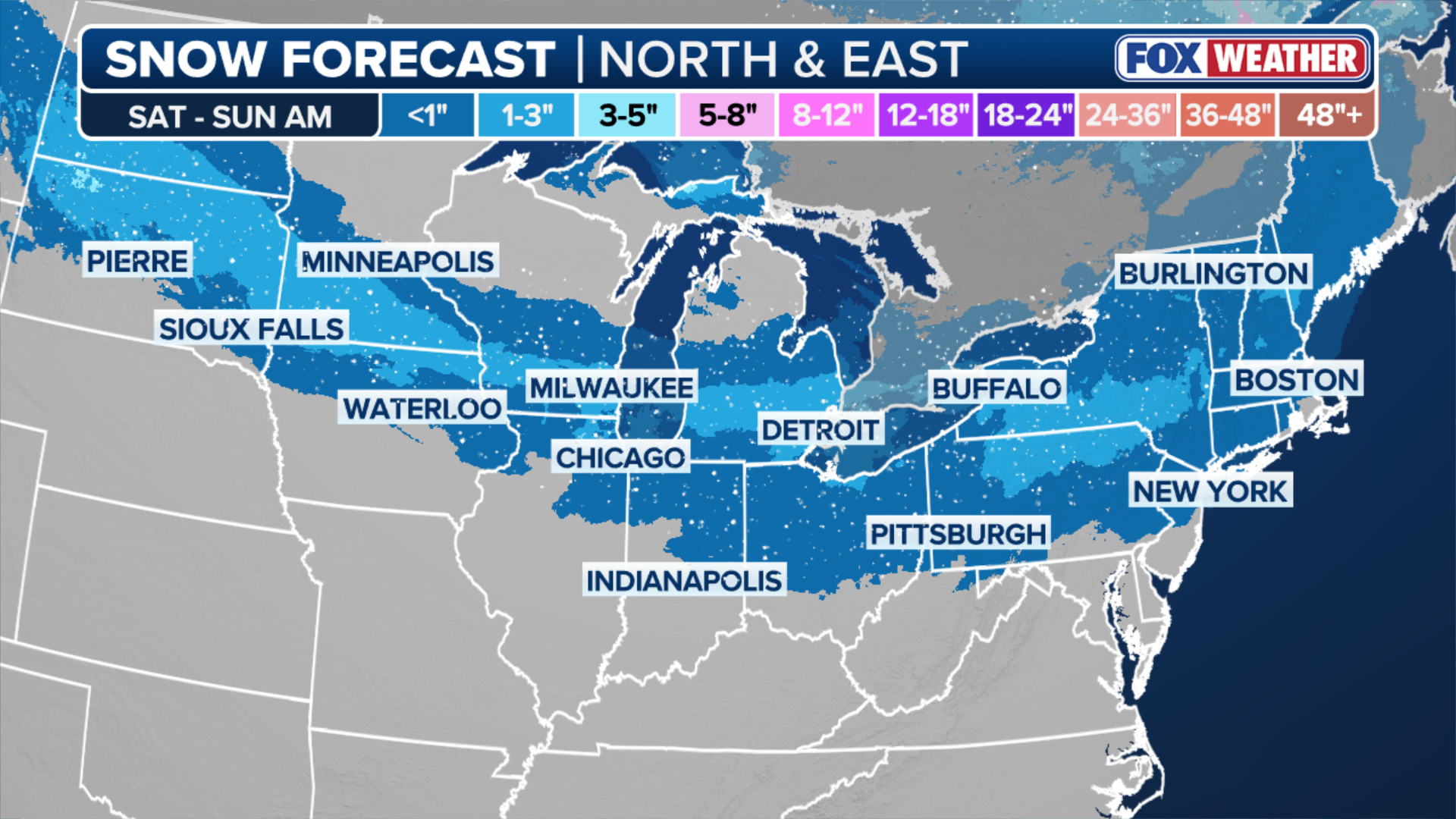
According to the FOX Forecast Center, snow will break out along the leading edge of cold air early Saturday across Montana and the Dakotas, before spreading to the Upper Midwest and Great Lakes by Saturday evening.
HURRICANE MELISSA TIES RECORD FOR STRONGEST HURRICANE IN ATLANTIC HISTORY
Winter Weather Advisories are in effect from Montana into Wisconsin.
Accumulation from this fast-moving system should be limited to less than 3 inches.
The cold air and snow will then reach the interior Northeast early Sunday morning, with the most snow expected in cities like Pittsburgh, Pennsylvania, Albany, New York and Manchester, New Hampshire.
(FOX Weather)
Snow will also reach New York City, Providence, and Boston by Sunday morning, but accumulations are expected to be an inch or less.
Some forecast models for the snow on Sunday have grown and parts of ski country in New England could see amounts higher than 3 inches. This will need to be monitored closely.
The same forecast models have a burst of snow from Boston to New York close to 12pm-2pm on Sunday. There could be some minor travel issues if there is heavier, wet snow.
Perhaps the bigger story with this first system will be the wild swing in temperatures this weekend into Monday. Highs will soar to near 50 degrees as far north as Manchester, New Hampshire on Saturday, only for a dramatic 20+ degree drop come Sunday.
As the strong front moves offshore early Sunday, temperatures across the Northeast will plummet as arctic air filter southward into the region. By Monday morning, wind chills in the single digits are expected along the I-95 corridor.
Second storm to pack stronger punch and brings ice threat for Midwest, Ohio Valley
Just as the first wave ends in the Northeast, a second storm will develop along the tail end of the passing cold front on Sunday night.
Warmer, moist air from the Gulf will be pulled north by strengthening southerly winds and ride up over the front — a phenomenon meteorologists call "overrunning."
According to the FOX Forecast Center, the region to monitor late Sunday is in the Heartland and parts of the Midwest. Snow and freezing rain will likely begin in Nebraska, Kansas and Missouri by 3-6pm CT.
Temperatures here will only be flirting with the freezing mark, and there will be a sharp transition from rain to freezing rain to snow. Cities like St. Louis, Kansas City and then extending east into Louisville, Indianapolis and Cincinnati.
Snow totals have gone drastically down and will now only be in the range of 1-3 inches, which is one of the low-end scenarios being monitored.
There will be some minor disruptions, but nothing major.
The threat of freezing rain has also gone way down, with totals only being near a glaze or up to 0.10 inches of ice accretion. Rain will likely overtake these areas that could see freezing rain, which would quickly melt any ice and likely any snow too.

(FOX Weather)
On Monday, the snow and ice may shift to the Mid-Atlantic. Some models keep a burst of heavy snow in the Virginias and Maryland, while others have no moisture leftover, leading to a mostly calm day.
Even if parts of the Mid-Atlantic do get a round of winter weather, temperatures will quickly warm. If snowfall does occur, the totals could be up to 3 inches for areas like Roanoke and possibly Richmond. Washington, D.C. would be in line for some snow, but very minor.
Third winter storm could bring a parting shot of snow, ice to Northeast
The third is expected to arrive on Tuesday, as moisture-laden air from the south gets caught between high pressure exiting off the Eastern Seaboard and a developing low-pressure system in the Plains.

(FOX Weather)
This storm is expected to deliver mostly beneficial, snow-melting rain.
However, the air should remain just cold enough across some parts of the Northeast for ice and snow.
"The best chance for accumulating snow will remain north of Interstate 90, while significant icing will be a concern across Pennsylvania, where below-freezing air will stay trapped in the valleys," the FOX Forecast Center said Friday.
Some cold air damming may make for a freezing rain concern in Virginia and North Carolina. This round of storms has potential ice totals in the 0.10-0.25 inch range due to a higher confidence of prolonged, colder air mass at the surface.
Back to the north, a stronger surge will allow for less snow, and an even greater coverage of freezing rain. The snow threat looks to be in Upstate New York, Connecticut, Rhode Island, Massachusetts and northward.
Totals from this round could be up to 6 inches through Wednesday, but the highest totals will most likely be at the higher elevations.
Bigger cities along the I-95 corridor, like New York City, Philadelphia, Baltimore and Washington, D.C., will be on the fringe of snow, ice and rain. Boston has the greatest chance of being in a longer stretch of snow.
Stick with FOX Weather as these systems continue to develop.