Eastern US begins to warm up while cold air returns to the West
By the end of the week, the eastern US could see temperatures 20 to 30 degrees above average
Eastern US to warm up this week while cold air returns to the West
By the end of the week, the eastern US could see temperatures 20 to 30 degrees above average.
A taste of spring will return to the Northeast starting Wednesday while bitterly cold air returns to the western U.S.
A major storm system is expected to bring heavy snow, flooding rain and high winds as it tracks across the West into the Plains, Midwest, South and then East.
The eastern half of the U.S. will enjoy above-average temperatures by the end of the week.
(FOX Weather)
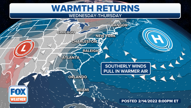
The area of low pressure will interact with an area of high pressure well off the East Coast, which will pull in warmer air from the south through the mid-Atlantic into the Northeast and New England.
Temperatures in the Northeast will continue to rise as the week continues.
(FOX Weather)
It's been bitterly cold in the Northeast over the past few days, but as the storm system in the middle of the country tracks east, it will push the mild air into the region.
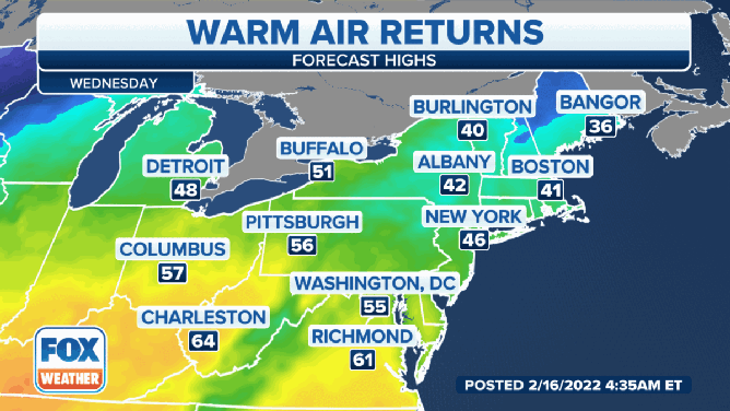
It will remain cold in northern Maine on Wednesday. Bangor is only expected to reach 36 degrees. But in southern New England, temperatures will be warmer. Boston is projected to reach 41 degrees. New York City will be around 46 degrees.
In the mid-Atlantic, temperatures will be milder. Washington, D.C., will get to around 55 degrees, while Richmond, Virginia, will see temperatures around 61 degrees.
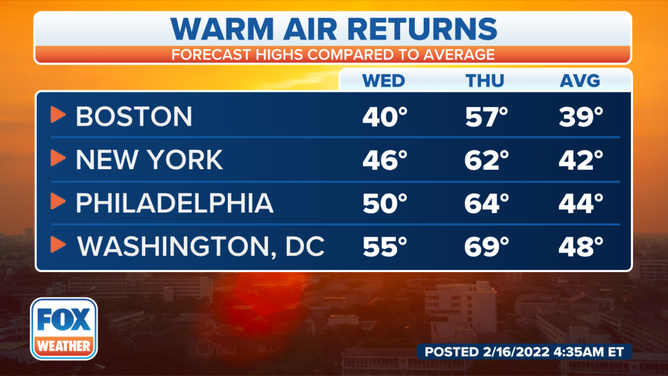
What a difference a day makes. Temperatures will jump nearly 20 degrees in many parts of the Northeast and mid-Atlantic between Wednesday and Thursday.
(FOX Weather)
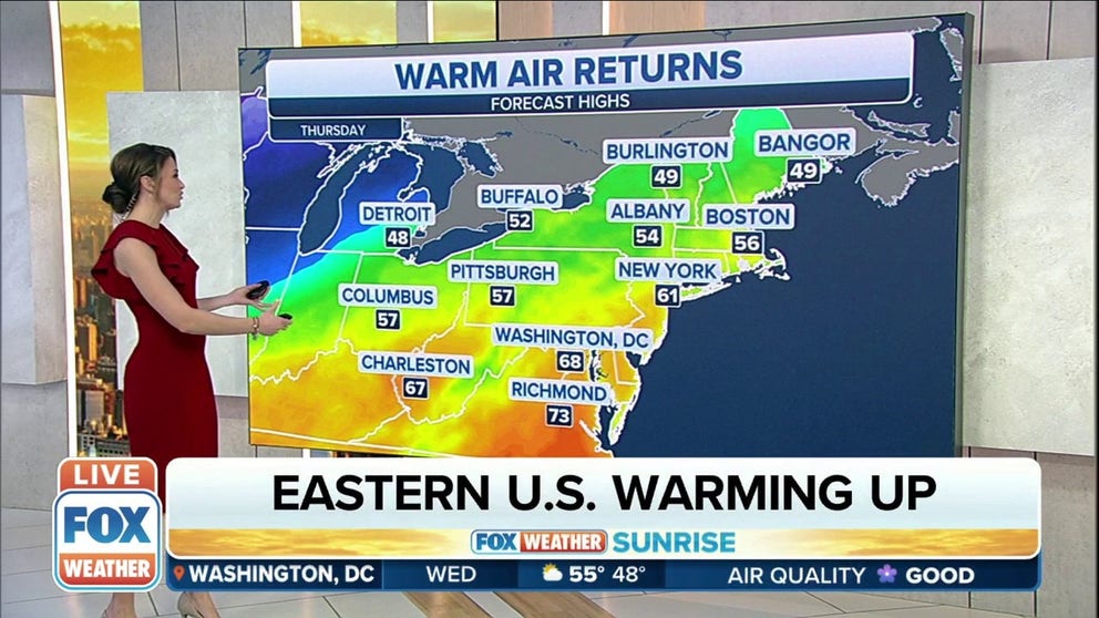
Thursday will be even warmer across the region. Burlington, Vermont and Bangor will be around 49 degrees. The rest of the Northeast and New England will enjoy temperatures in the mid to upper-50s.
New York City will get above 60 degrees during the day Wednesday, and areas of the mid-Atlantic could top 70 degrees.
Most of the region will remain mild on Friday, but the cold air will be creeping closer. Temperatures will only be in the 20s from Detroit, Michigan, to Buffalo, New York and Burlington. But areas closer to the coast, like Bangor, Boston, Providence and Hartford, will remain in the 50s.
New York City will again enjoy temperatures around 60 degrees.
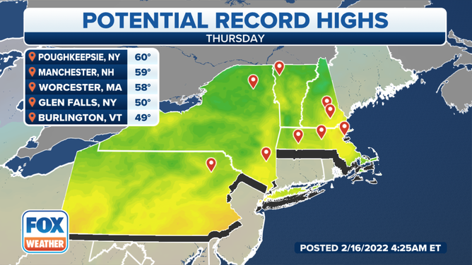
Records are in jeopardy of being broken on Thursday.
(FOX Weather)
Several record-high temperatures could be broken as we get closer to the end of the week. And while the eastern half of the country will enjoy a few days of mild temperatures, the cold air is returning to the central part of the U.S.
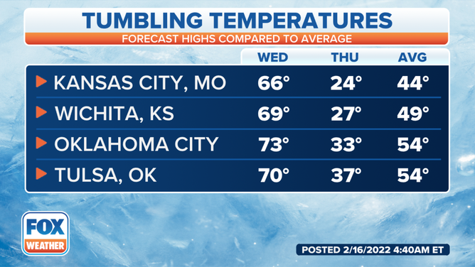
Temperatures in the central U.S. will drop dramatically between Wednesday and Thursday.
Kansas City, Missouri, will be in the mid-60s on Wednesday, but temperatures will drop well below freezing on Thursday as the storm system moves through the region.
Wichita, Kansas, Oklahoma City and Tulsa, Oklahoma, will all enjoy temperatures near or above 70 degrees on Wednesday, but high temperatures will be 30 degrees lower Thursday.
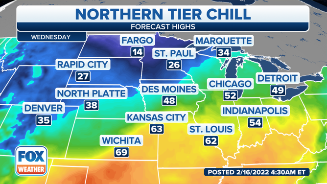
High temperatures on Wednesday.
(FOX Weather)
The Northern Plains will be cold on Wednesday, while the Central and Southern Plains will be enjoying one last day of the warmer temperatures.
Fargo, North Dakota, will only get to around 14 degrees Wednesday afternoon, and St Paul, Minnesota, will be below freezing at 26 degrees.
To the south, Des Moines, Iowa, will be around 48 degrees.
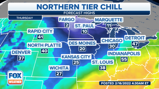
High temperatures on Thursday.
(FOX Weather)
The big chill returns on Thursday. On Wednesday, areas enjoying temperatures in the 60s and 70s will plunge by Thursday.
On Thursday, Northern Minnesota and eastern North Dakota will stay in the single digits. It will also remain well below freezing from Des Moines into Kansas City and Wichita.