Sprawling winter storm stretching 1,000+ miles to bring dangerous snow and ice across Northern Tier
The complex system spanning over 1,000 miles is on track to bring dangerous snow and icing from the Plains to New England this week, with blizzard conditions possible.

Winter storm spanning 1,000+ miles on track to bring dangerous heavy snow and ice from Plains to New England
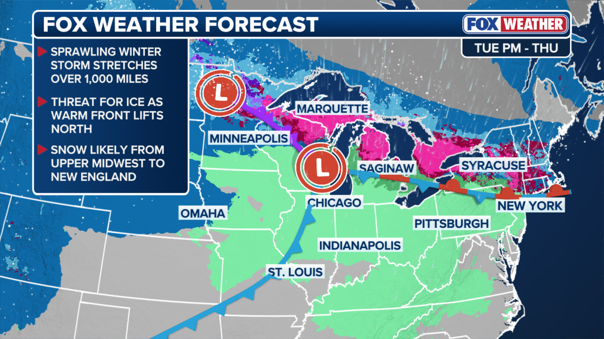
A complex winter storm spanning more than 1,000 miles is on track to bring a dangerous mix of heavy snow and ice from the Plains to New England through Thursday. As the storm intensifies, winds exceeding 40 mph could create blizzard conditions across parts of the Northern Tier, prompting Blizzard Warnings. Stay with FOX Weather for the latest updates.
Winter’s grip is holding on tight over the Northern Tier as the FOX Forecast Center is tracking yet another round of snow, even ice and freezing rain through Thursday.
The complex system will span over 1,000 miles, bringing dangerous snow and icing from the Plains to New England this week.
(FOX Weather)
Blizzard Warnings are now in effect in Montana and the Arrowhead of Minnesota, where snow and wind will have a significant impact in the Northern Plains.
In the Northeast, snow will fall along and generally north of I-90, including Boston. Just south of the snow, an even narrower region of icing may be a concern.
(FOX Weather)
LIGHT SNOW MOVES ACROSS NORTHEAST, MINOR TRAVEL ISSUES POSSIBLE AFTER SEVERE STORMS IN THE SOUTH
A strong system will develop in the West before racing across the Northern Tier. It should take shape in the Northern Rockies on Tuesday, strengthen across the Northern Plains, and track toward the Great Lakes.
The FOX Forecast Center said the storm will likely be unusually intense for February.
The storm will have plenty of fuel, drawing in unusually high moisture for this time of year from both a Pacific surge moving in from the Southwest and additional moisture from the Gulf of America.
'SIGNIFICANT AND DANGEROUS' STORM TO UNLEASH SEVERE WEATHER, FLOODING THREAT FOR SOUTHERN CALIFORNIA
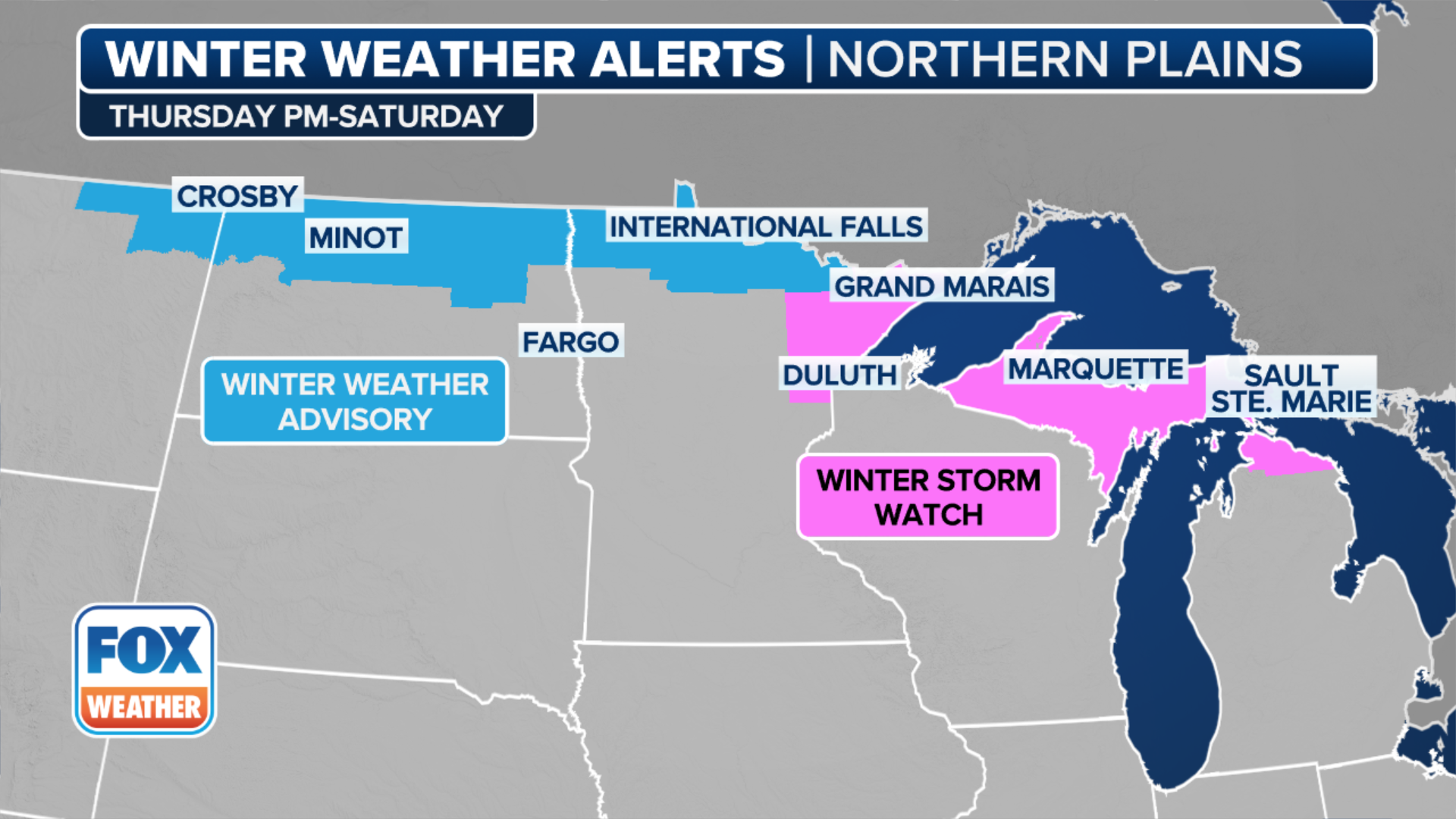
As it intensifies, northern Minnesota and North Dakota will be in a favorable position for heavy snow Tuesday night into Wednesday morning, with the heaviest snow expected north of I-94, near the international border, where up to 8 inches is likely.

(FOX Weather)
Strong winds expected to exceed 40 mph have already prompted Blizzard Warnings for eastern Montana and the Arrowhead of Minnesota.

FILE - Two people pushed through the snow and wind in Canal Park in Duluth, MN to check out the waves and severe flooding during the snow storm on Saturday, November 30, 2019.
(Alex Kormann/Star Tribune / Getty Images)
The FOX Forecast Center is calling the Arrowhead of Minnesota the "big winner" for this storm, as the orographic lift will enhance snowfall as southeast winds will pull moisture from Lake Superior over the Misquah Hills.
This setup could result in up to 18 inches of snow in just two days.

(FOX Weather)
Just south of the snow, a narrow corridor of freezing rain will set up.
A glaze could make travel dangerous from extreme northeast North Dakota, through northern Minnesota, the Upper Peninsula of Michigan, upstate New York and into New England.
![A resident clears snow surrounding a vehicle in Somerville, Massachusetts, US, on Monday, Jan. 26, 2026.]() Image 1 of 3
Image 1 of 3A resident clears snow surrounding a vehicle in Somerville, Massachusetts, US, on Monday, Jan. 26, 2026. (Mel Musto/Bloomberg)
![Snow covered vehicles parked on a street during a snowstorm in Chicago, Illinois, US, on Saturday, Nov. 29, 2025. Hundreds of flights have been canceled in and around Chicago and roads are becoming treacherous as one of the busiest travel weekends of the year collides with a major storm bringing wintery conditions throughout the US Midwest Saturday.]() Image 2 of 3
Image 2 of 3Snow-covered vehicles parked on a street during a snowstorm in Chicago, Illinois, US, on Saturday, Nov. 29, 2025. Hundreds of flights have been canceled in and around Chicago and roads are becoming treacherous as one of the busiest travel weekends of the year collides with a major storm bringing wintery conditions throughout the US Midwest Saturday. (Photographer: Jim Vondruska/Bloomberg via Getty Images)
![BOSTON, MA - January 26: Snow banks in front of Boston City Hall on January 26, 2026.]() Image 3 of 3
Image 3 of 3BOSTON, MA - January 26: Snow banks in front of Boston City Hall on January 26, 2026. (David L. Ryan/The Boston Globe )


By Wednesday, the system should begin to weaken as it spreads wintry precipitation into the Northeast.
In the morning, the narrow swath of moisture will move eastward from the Great Lakes before exiting the New England coast by Thursday morning.
Significant snowfall accumulations will be largely confined to elevations above 1,000 feet or areas where intense dynamic cooling can overcome above-freezing surface temperatures, according to the FOX Forecast Center, with the most significant totals expected from Upstate New York into western Vermont.
In the Boston metro area, snow will likely arrive on Wednesday night, with a few inches possible before the system clears out prior to Thursday’s sunrise.