Soggy April in the Northwest becomes record wet April in Portland
With yet another rainy morning Saturday, Portland has received over 5.30" for the month, making this April the wettest April on record at Portland International Airport.
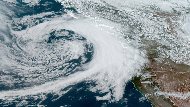
(RAMMB/CIRA/NOAA)
PORTLAND, Ore. -- In the Pacific Northwest, spring usually begins the slow transition from the rainy winter to the summer dry season.
But this year, the transition has been slower than slow. You could forgive many in the Northwest for wondering if the transition has even begun.
A series of weather systems have been peppering Washington and Oregon through the month keeping skies generally cloudy, temperatures cooler than average and puddles in plentiful supply.
With yet another rainy morning Saturday, Portland received 5.73" for the month, making this April the wettest April on record at Portland International Airport where records go back to 1940.
And it hasn't come in just a few days; measurable rain has fallen there on 24 of April's 30 days -- good to tie for the second-most days with rain in April behind 2010's 25 days with rain.
More than half of the days this month have featured average temperatures at least 4 degrees below normal or more. Average highs are in the low-mid 60s but temperatures have made it out of the 50s on 20 of April's 30 days. They had just as many days in the 70s -- two -- as they did in the 40s!
Portland has even managed to out-drench its usually rainier neighbor Seattle. Not that it's been dry in the Emerald City either with rain on 20 of April's 30 days, but despite the frequent rainfall, it hasn't added up to as much in the rain gauge. Seattle is sitting at about a half inch below average for April rainfall.
Boon for the Mountains
While the rain has been keeping outdoor plans on contingent status, snow has continued to fall in the Cascades, shoring up summer water supplies and keeping the ski season going into May for some spots.
In Washington, Snoqualmie Pass had their third-snowiest April, while Chinook Pass has seen 80-100 inches of snow in just the first three weeks of the month.
The Northern Oregon Cascades are running over 44% above average with the Moot Hood area a whopping 70% above average.
May is looking no different
Northwesterners hoping the weather patten will flip with the calendar will have to pin their hopes on June. La Nina conditions remains strong in the central Pacific Ocean and that tends to keep it cool and wet in the Pacific Northwest.
Sure enough, an active jet stream will continue to steer storms into the Pacific Northwest into the first week of May, with another rainy day on tap for Monday and again by the following weekend.