Severe storms target Northern Plains with powerful winds, large hail threat heading into workweek
Severe storms will persist across the Northern Plains and Upper Midwest on Sunday, with the primary threats being damaging wind gusts and isolated large hail.

Severe storms taking aim at the Northern Plains through the weekend and into early next week
Storm energy is building across the Northern Plains as the day goes on, with severe weather expecting to take charge heading into Sunday. Strong winds and hail are the primary concerns through the evening. Storms continue to dominate heading into Monday.
The Northern Plains are set to be rocked by severe weather for three days in a row, as storms charge up to bring very strong, gusty winds and large hail into Monday.
According to the FOX Forecast Center, storms will really power up in the late afternoon and evening hours across Nebraska, North and South Dakota, Montana and Wyoming.
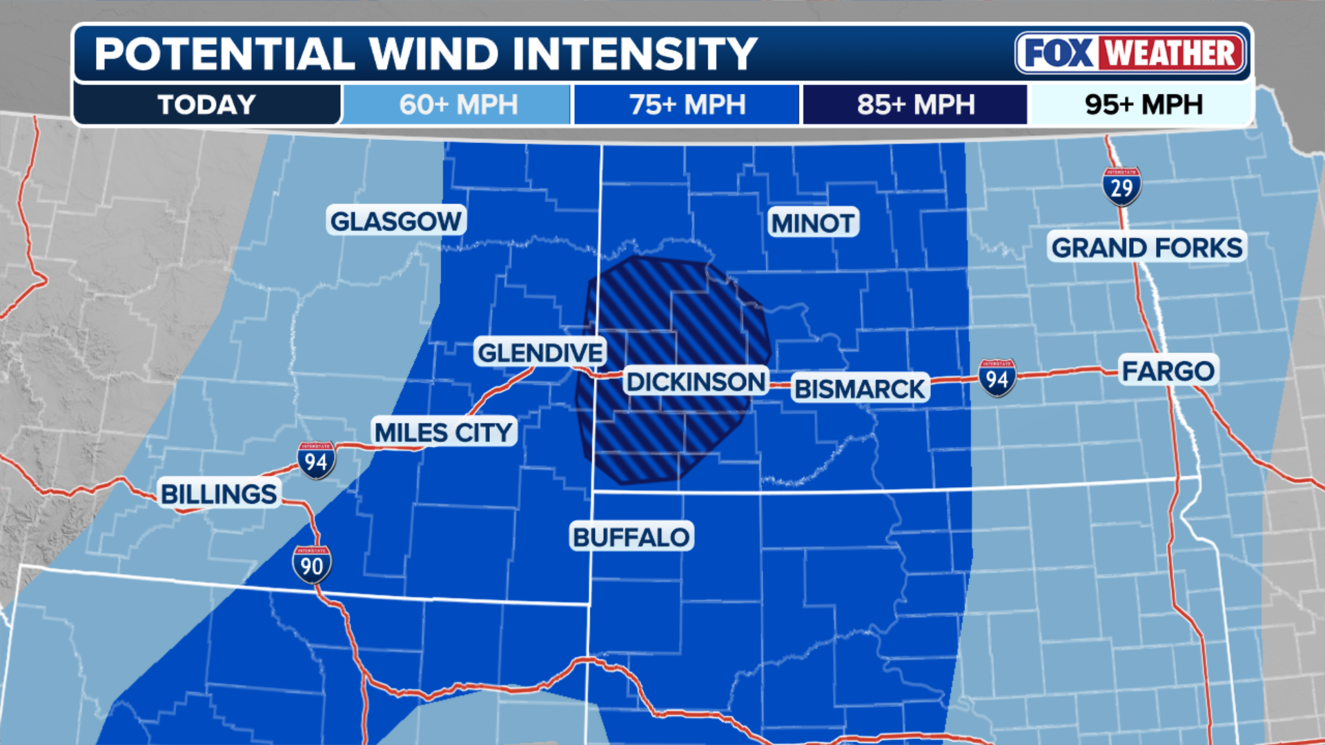
A Level 3 out of 5 severe storm threat is in effect for Saturday in North Dakota, South Dakota and Montana, primarily due to the threat of winds gusting 85 mph or stronger.

(FOX Weather)
According to the FOX Forecast Center, a shifting pattern will send powerful, fast-moving winds into a moisture-rich environment, creating the setup for severe weather that could last several days.
ILLINOIS LEADS THE COUNTRY FOR MOST TORNADO REPORTS SO FAR IN 2026 AND IT'S ONLY JUNE
Severe storms will persist across the Northern Plains and Upper Midwest on Sunday, with the primary threats being damaging wind gusts and isolated large hail.
(FOX Weather)
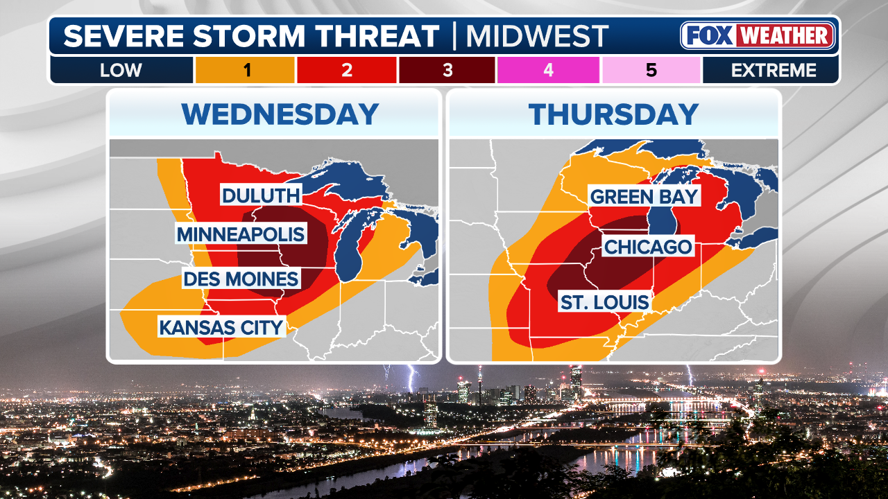
A Level 2 out of 5 severe storm threat is highlighted across northern portions of North Dakota and Minnesota, where these hazards are most likely to come to fruition later in the day Sunday.
Grand Forks and Fargo, North Dakota, are both in the level 2 zone.

Storm clouds above isolated house. South Dakota. USA.
(Dr Mike Hill / Getty Images)
Widespread coverage of severe storms is not guaranteed, the FOX Forecast Center said, due to an atmospheric "cap," which could suppress thunderstorm development despite a heavily primed environment with plenty of instability for storm formation.
(FOX Weather)
Some storms will ripple through the area throughout the day, but the timing and severity will depend on if this atmospheric cap can be breached.
On Monday, extreme heat and severe weather will target Minneapolis, creating massive instability, which allows storms to thrive.
HERE ARE 8 OF THE BIGGEST WEATHER MYTHS EXPLAINED
The FOX Forecast Center said that while the strong atmosphere cap may initially suppress widespread daytime storms, any cell that manages to break through this cap will rapidly intensify.
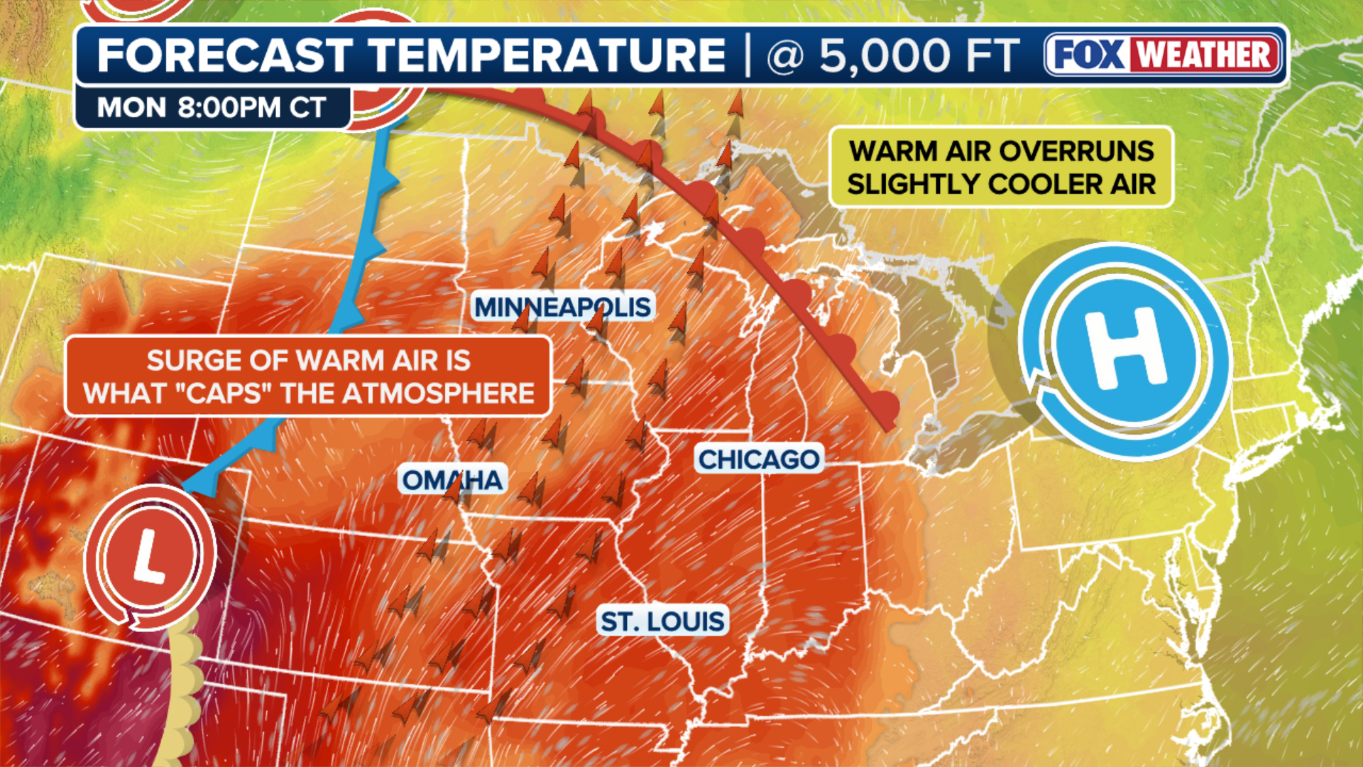
(FOX Weather)
Another Level 2 out of 5 threat is in effect, this time focused on Minnesota, parts of Wisconsin, Iowa, Nebraska and South Dakota.
Like Sunday's storms, Mondays will carry a substantial risk for damaging wind gusts, large hail and localized flash flooding across the Minneapolis metro area.
SNOW, SLEET, FREEZING RAIN AND HAIL: WHAT'S THE DIFFERENCE?
A Level 1 out of 4 flash flooding threat is in place across the Northern Tier through the weekend.

MINNEAPOLIS, MN. - JULY 2022: Storm clouds roll in Tuesday, July 12, 2022 over the Basilica of Saint Mary in Minneapolis, Minn..
( Alex Kormann/Star Tribune / Getty Images)
By Tuesday, storms will have moved out of the region.
Stay with FOX Weather for the latest forecasts as severe storms ramp up.