Severe weather reloads over Midwest, Plains with storms blasting more than 65M from Texas to Pennsylvania
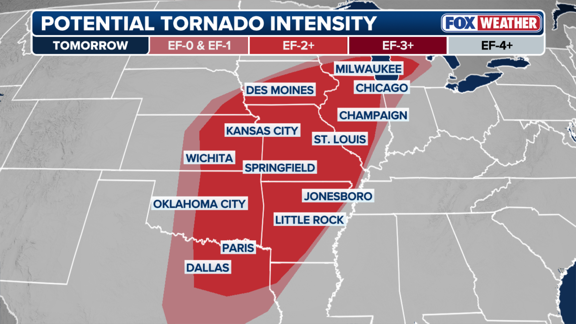
Portions of southern Iowa and northern Missouri are under a Level 3 out of 5 risk of severe thunderstorms, according to NOAA's Storm Prediction Center. This area faces the greatest risk of seeing supercell thunderstorms capable of producing tornadoes — just south of Thursday's most intense storms.

More than 65 million under a risk for severe storms across the Plains, Midwest
Parts of the Midwest and the Plains are once again in the bull's-eye of severe weather expected to produce large hail and damaging wind gusts beginning Friday afternoon from Texas to Pennsylvania. FOX Weather Meteorologists Bob Van Dillen and Jane Minar have the latest:
KANSAS CITY, Mo. — Parts of the Midwest are once again in the bull's-eye of a line of severe thunderstorms that are unleashing large hail and damaging wind gusts from Iowa to Texas.
The overall threat covers more than 65 million people over 1,500 miles from the Big Bend of Texas to western Pennsylvania.
![Rope tornado spotted in West Liberty, Iowa Thursday.]() Image 1 of 2
Image 1 of 2Rope tornado spotted in West Liberty, Iowa Thursday. (Drew Brummel via Storyful)
![Wind gusts damage farm in West Branch, Iowa on Thursday]() Image 2 of 2
Image 2 of 2Wind gusts damage farm in West Branch, Iowa on Thursday. (KGAN)


Portions of southern Iowa and northern Missouri are under a Level 3 out of 5 risk of severe thunderstorms, according to NOAA's Storm Prediction Center.
This area faces the greatest risk of seeing supercell thunderstorms capable of producing tornadoes — just south of Thursday's most intense storms.
WHAT IS A SUPERCELL THUNDERSTORM?
There will be a narrow window from mid-to late Friday when these supercells are most likely to form.
(FOX Weather)
Warm air high in the atmosphere on Thursday prevented many tornado-generating storms from forming.
However, egg-sized hail was reported across parts of eastern Iowa and western Illinois by the National Weather Service (NWS), as well as widespread reports of damaging wind gusts that reached 65 mph.
ARTEMIS II MAKES HISTORY, BRINGING HUMANS AROUND THE MOON FOR THE FIRST TIME IN 50 YEARS

Watch: Rope tornado spins across West Liberty, Iowa
A rope tornado was spotted touching down in West Liberty, Iowa Thursday afternoon and the roof was ripped off part of a small farm in nearby West Branch. No injuries have been reported.
A rope tornado was spotted touching down in West Liberty, Iowa Thursday afternoon and the roof was ripped off part of a small farm in nearby West Branch. No injuries have been reported.

Wind gusts damage farm in West Branch, Iowa on Thursday.
(KGAN / FOX Weather)
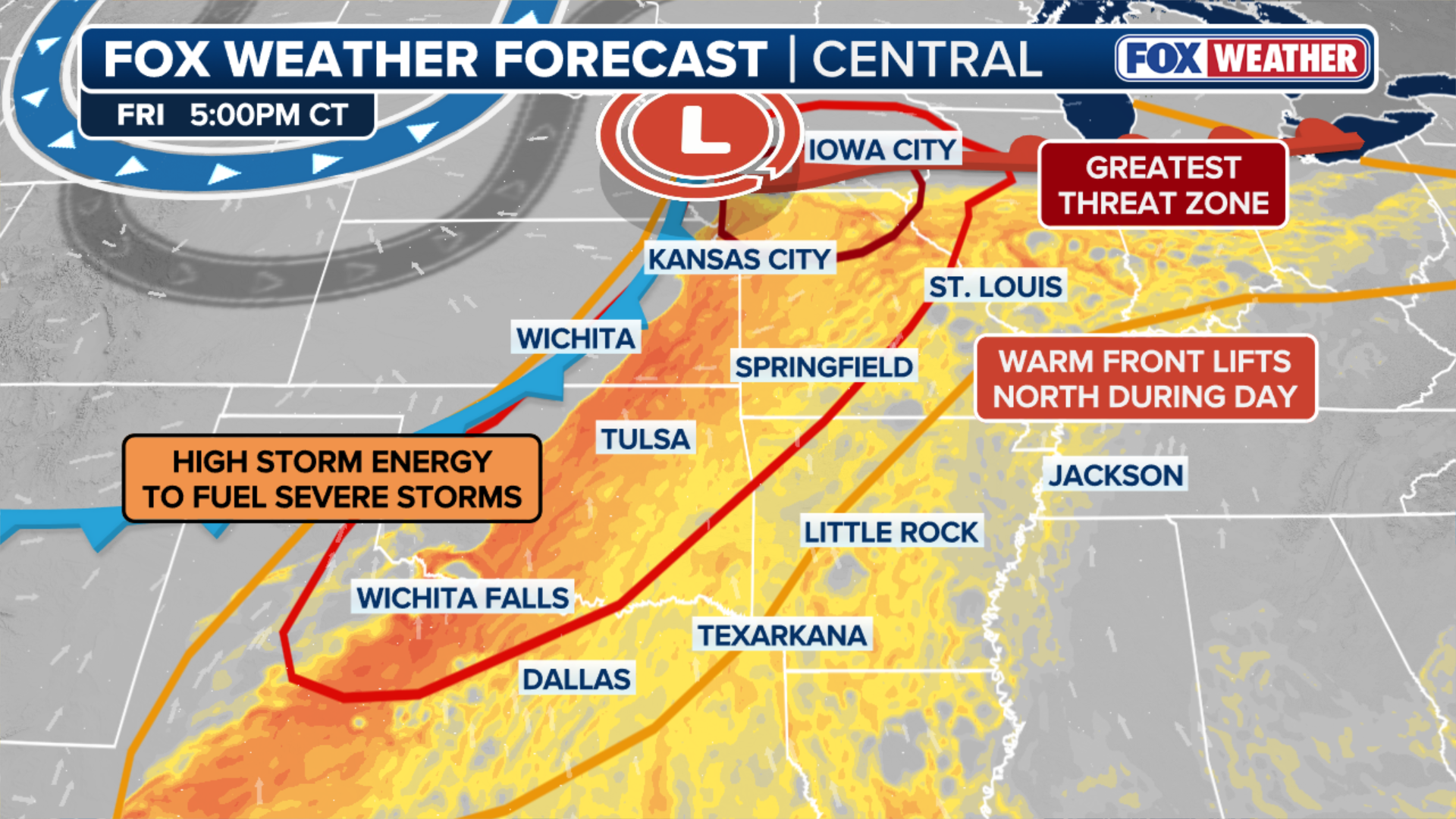
Storms to blast Central and Southern Plains Friday
A second severe weather system is moving out of the Rockies and into the Plains.
Thunderstorms are firing up ahead of and along the associated cold front from the Ohio Valley to Texas into tonight. All hazards are possible, including damaging winds, large hail and tornadoes.

(FOX Weather)
According to the FOX Forecast Center, storms will fire along a dryline — the boundary between dry air from the west and warm, moist air from the Gulf — across western Oklahoma into West Texas.
(FOX Weather)
Storms will organize into a line from western Iowa to West Texas Friday evening and charge eastward overnight, with the greatest threat being damaging wind gusts in Kansas and Oklahoma.
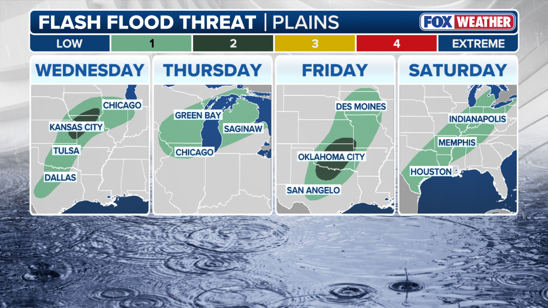
Flash flood threat extends into holiday weekend for Southern Plains, Midwest
In addition to the severe weather hazards, the FOX Forecast Center noted that the significant moisture in the atmosphere and the repeated number of storms moving across the same region could lead to flash flooding from northern Texas into southwestern Missouri, where a Level 2 out of 4 flash flood risk is in place through Saturday morning.
(FOX Weather)
A widespread 2-3 inches of rain is possible from Dallas to Kansas City through Saturday.
Flash flooding closed multiple roads in Johnson County, Missouri, just east of Kansas City, on Thursday.

Flash flooding closed multiple roads in Johnson County, Missouri Thursday.
(WDAF / FOX Weather)
This active severe weather pattern comes right on cue, as April is historically when spring severe weather season begins to intensify across the middle of the country.