Over 40 million Americans across Central US facing giant hail, damaging wind threat as severe storms reload
Giant hail and damaging winds are the primary threats with Saturday's storms, but some tornadoes may be possible.

Severe storms charging over Plains, Midwest with hail, tornado, damaging wind threat
Severe storms are powering up and are expected to fire off this evening. A level 3 out of 5 threat reached across Nebraska and Kansas through tonight. The primary concern with these storms are damaging winds, large hail and even some tornado possibility.
Severe storms are taking shape across the Plains and Central U.S. on Saturday, marking the latest round in a multiday severe weather threat targeting more than 1,200 miles and 40 million Americans from now until Tuesday.
Numerous severe thunderstorms occurred from Texas through Iowa on Friday, with damaging wind gusts of more than 65 mph and large hail were the biggest reports.
More of the same is expected on Saturday, with giant, destructive hail and strong, damaging wind gusts as the primary threats.
(FOX Weather)
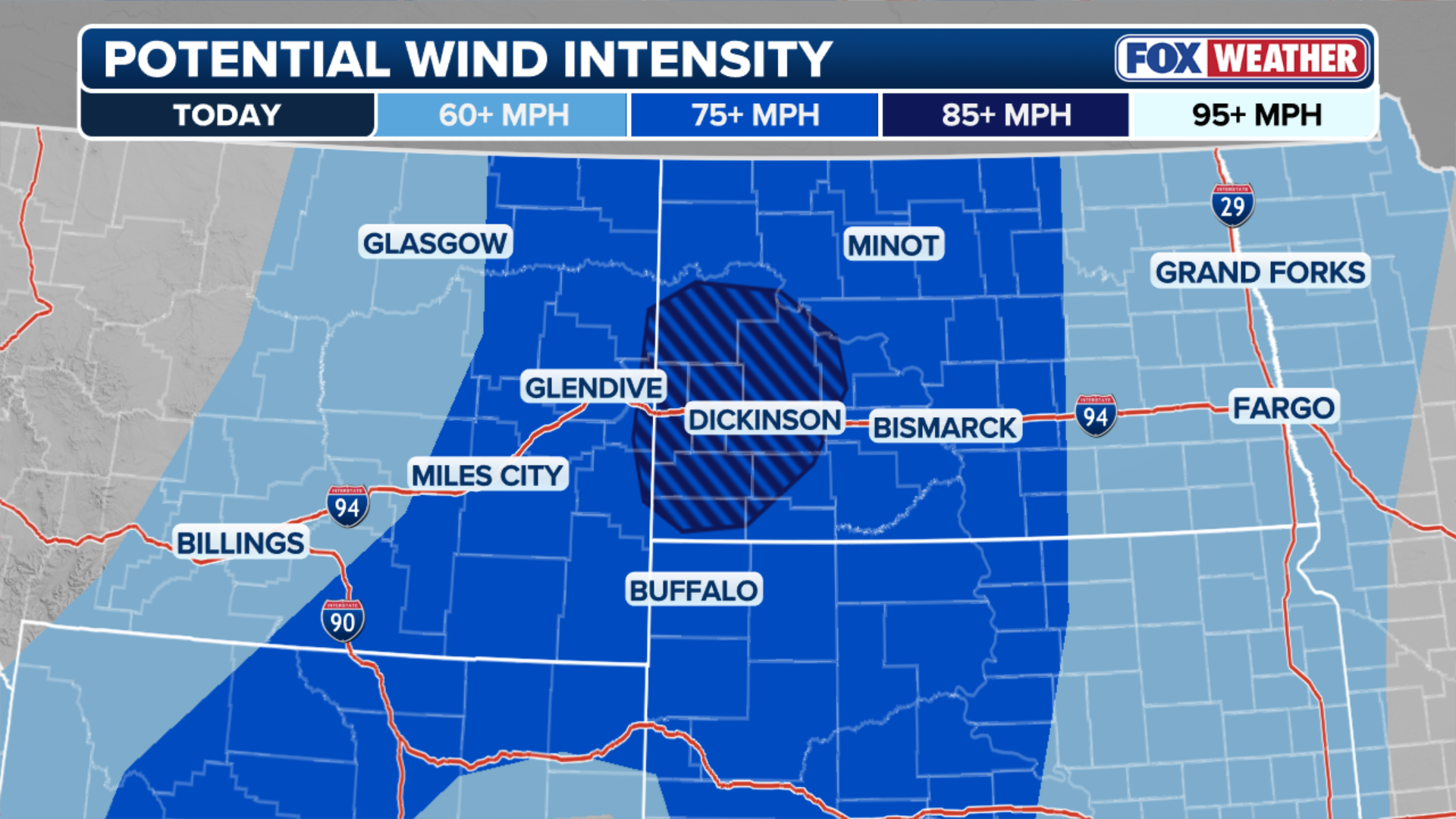
A level 3 out of 5 severe storm threat hangs over southwestern Nebraska, northeastern Colorado and northwestern Kansas through Saturday night.

(FOX Weather)
Meanwhile, Saturday features a much larger level 2 out of 5 threat for Iowa, parts of northern Missouri, Kentucky and the southeastern tip of South Dakota, as well as Colorado, Kansas and Nebraska.
WHAT IS A SUPERCELL THUNDERSTORM?
Storms are expected to remain spotty and broken through the afternoon hours.
In Indianapolis, the Indianapolis Motor Speedway briefly evacuated the stands at the Indy500 qualifiers due to lightning.
🚨WEATHER ADVISORY🚨
— Indianapolis Motor Speedway (@IMS) May 16, 2026
Lightning has been detected in the vicinity of the Speedway. Please exit the grandstands in an orderly fashion and seek shelter. You should implement your personal safety plan.
By the evening, supercell thunderstorms are expected to merge into a larger storm complex with more storm energy, according to the FOX Forecast Center.

(FOX Weather)
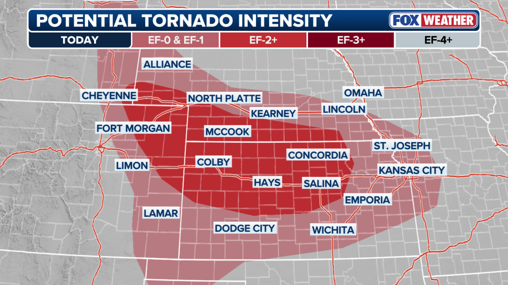
Hail 3 inches or larger in diameter, along with damaging winds of 65 mph or stronger are the main risks with these storms, but the FOX Forecast Center warned that some tornado formation may be possible, especially across Nebraska and Kansas.
(FOX Weather)
The multiday threat began on Thursday when numerous Severe Thunderstorm Warnings were issued across the Texas and Oklahoma Panhandles, with wind gusts of 70 mph reported. Video on social media showed cloud-to-ground lighting during severe storms in southern Kansas.

Lightning strikes Harper, Kansas, during severe thunderstorms on Thursday.
(Mateusz Taszarek via Storyful / FOX Weather)
Severe weather is expected to last through the weekend and into the early part of next week.
The SPC is now warning that there is an "increasing chance of strong to intense tornadoes" on Monday afternoon in central Kansas into northern Oklahoma.

(FOX Weather)
FOX Weather has the latest coverage throughout all the severe storms. Get the latest forecast for the storms early next week on FOX Weather.