Severe Thunderstorm Watches issued as severe weather threatens Upper Midwest, Southern Plains
Severe Thunderstorm Watches have been issued for parts of the Upper Midwest and Central Plains through the evening.
Severe storms threaten Upper Midwest, Plains
A Severe Thunderstorm Watch has been issued for parts of Minnesota, Wisconsin, Oklahoma, Kansas and Missouri. Sept. 5, 2023.
Severe storms with isolated large hail and damaging winds will be possible on Tuesday across parts of the Upper Mississippi Valley, including the Minneapolis area, and farther south into a swath that covers parts of Missouri and Oklahoma.
The threat on Tuesday comes a day after severe thunderstorms slammed the Dakotas and parts of Missouri with ferocious wind gusts that reached 70-80 mph or more.
The cold front continues to move eastward from the Northern Plains into the Upper Mississippi Valley, with high amounts of moisture surging north ahead of the front, according to the FOX Forecast Center.
Where are the storms now?

(FOX Weather)
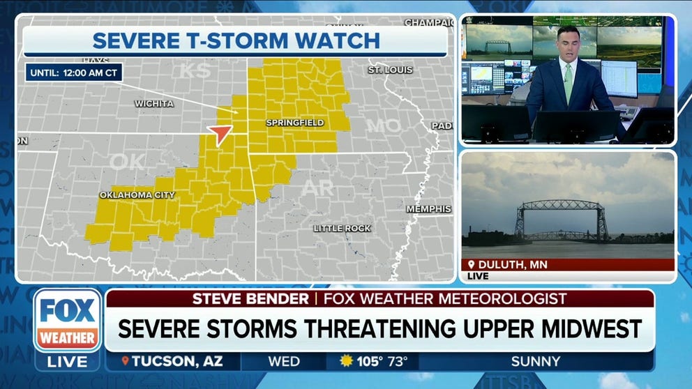
Severe Thunderstorm Watches have been issued for parts of the Upper Midwest and Central Plains through the evening.
A Severe Thunderstorm Watch is in place for eastern Minnesota and northwest Wisconsin through 11 p.m. CT.

(FOX Weather)
Another Severe Thunderstorm Watch was issued for Oklahoma, Kansas and Missouri until 12 a.m. CT.

(FOX Weather)
Tuesday's severe weather forecast
NOAA's Storm Prediction Center has issued a Level 2 out of 5 on their Severe Weather Risk scale for much of Minnesota and northwestern Wisconsin, including Minneapolis and Duluth, as well as parts of Oklahoma through Missouri.
THE 5-POINT SEVERE THUNDERSTORM RISK CATEGORY SCALE EXPLAINED

(FOX Weather)
This environment will likely support supercells with gusts over 60 mph and isolated large hail, and a few isolated tornadoes can't be ruled out. The severe threat will continue throughout the evening as a large cluster of storms moves eastward toward the Great Lakes.
A second area of concern covers southwestern Missouri into northeastern Oklahoma, including Springfield, Missouri, Tulsa, Oklahoma and even the northern Oklahoma City suburbs.
Here again, the front is expected to tap into a moist, unstable airmass that will fuel isolated supercell thunderstorm development into the evening. These storms look more isolated in general, but where storms do happen, gusts could reach well over 60 mph. Large hail is also possible, but the primary threat is strong wind.
Again, NOAA's SPC has highlighted this area as a Level 2 out of 5 risk for severe weather Tuesday:

(FOX Weather)
Storms brought 70-80 mph winds to Dakotas Monday
The storms come a day after much of the Dakotas were blasted by severe wind gusts. Strong thunderstorms formed into a line across the Dakotas and Northern Plains, triggering gusts of 70-80 mph or more.
Selfridge, North Dakota reported a gust of 88 mph Tuesday evening, while Sibley Peak, Wyoming, hit 78 mph, North Platte, Nebraska, hit 76 mph, and Meadow, South Dakota, hit 72 mph. In all, there were nearly 30 storm reports of gusts of 60 mph or higher in the region, according to National Weather Service storm reports.
A second cluster of strong thunderstorms hit Missouri Monday evening, with peak gusts of 66 mph in Northwye and 60 mph in Farmington. The fire department in Doolittle, Missouri, responded to "countless wires down and trees blocking roadways."
Severe storms move east on Wednesday
The cold front will continue east across the Mississippi River Valley on Wednesday, the FOX Forecast Center said.
Similar ingredients will lead to strong thunderstorms forming during the mid-to-late afternoon near and ahead of the front. Isolated wind damage would be the primary threat, although a large hail threat may also occur in some of the stronger storms.
The severe threat could persist into the evening as the cold front moves into the lower Ohio Valley.

(FOX Weather)
Multiple days of rain inbound for the Northeast, Mid-Atlantic
The line of storms will continue into the Ohio River Valley and eventually drape over the East Coast heading into the weekend. Most of the Northeast and Mid-Atlantic states will see multiple days of rain, which will usher in heat relief.
Outdoor activities could be limited as pockets of heavy rain disrupt the afternoon hours.
As the system progresses east, the front will extend down to the Gulf Coast bringing some beneficial rain to the south. The front is likely to stall allowing for showers and thunderstorms to break out across Texas and Louisiana where rain is desperately needed.

(FOX Weather)