Damaging winds, tornadoes cross Appalachians, mid-Atlantic on Tuesday
The National Weather Service received over 150 reports of damaging wind gusts, tree falls, and large hail across eastern Kentucky, eastern Tennessee, western Virginia and North Carolina and into Alabama.
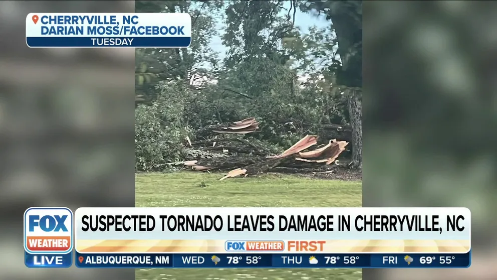
Possible tornado leaves damage across Cherryville, NC
A summerlike pattern brought thunderstorms and heavy rain across the central and southern Appalachians and parts of the mid-Atlantic on Tuesday. A possible tornado left damage across Cherryville, NC on Tuesday as well.
A summerlike pattern brought thunderstorms and heavy rain across the central and southern Appalachians and parts of the mid-Atlantic on Tuesday.
Strong to severe storms, associated with wind damage, isolated large hail and a few tornadoes, fired up during the peak heating of the day and slowly settled down well after sunset.
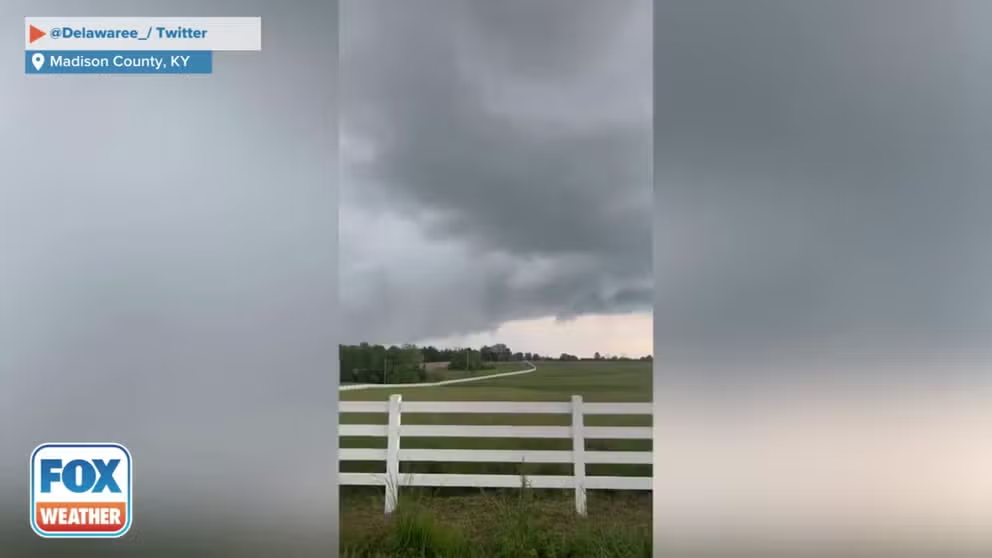
Tornado sirens wail in Madison County, Kentucky
Sirens wail as a tornado-warned storm rolls through Madison County in Kentucky on Tuesday. (Credit: @Delawaree_/ Twitter)
The National Weather Service received over 150 reports of damaging wind gusts, tree falls, and large hail across eastern Kentucky, eastern Tennessee, western Virginia and North Carolina and into Alabama.
Officials found that an EF-1 tornado crossed a highway in Duffield, Virginia, and uprooted some trees. They say the twister had winds of 100 mph and traveled just over half of a mile.
The NWS confirmed another tornado through radar in Magoffin County, Kentucky while in the town of Raccoon, spotters observed tennis ball-sized hail.
Several fences were blown down by a radar-confirmed microburst in Snow Hill, Alabama and a tree fell through a home's roof in Cahaba Heights, Alabama.
One person was injured in Boonevillle, North Carolina as a tree fell into a home and another tree fell onto a car.
Another person was injured in Cherryville, North Carolina near Charlotte. Two residents there sent several photos of trees down into homes and power lines across town as severe thunderstorms swept through. The National Weather Service sent a storm survey team to the damage site and determined the winds were caused by thunderstorms, not tornadoes, but did reach gusts as high as 85 mph.
The injury occurred when a person ran to help someone trapped in a car and got blown off their feet as another tree fell, suffering cuts and a broken jaw, the National Weather Service said.
![Wind damage in Cherryville, NC]() Image 1 of 16
Image 1 of 16Trees fall onto home in Cherryville, NC on May 16, 2023. (Wendy Swarr Tucker / Facebook)
![Wind damage in Cherryville, NC]() Image 2 of 16
Image 2 of 16Trees fall onto home in Cherryville, NC on May 16, 2023. (Wendy Swarr Tucker / Facebook)
![Wind damage in Cherryville, NC]() Image 3 of 16
Image 3 of 16Trees fall onto home in Cherryville, NC on May 16, 2023. (Wendy Swarr Tucker / Facebook)
![Wind damage in Cherryville, NC]() Image 4 of 16
Image 4 of 16Trees fall onto home in Cherryville, NC on May 16, 2023. (Wendy Swarr Tucker / Facebook)
![Wind damage in Cherryville, NC]() Image 5 of 16
Image 5 of 16Trees fall onto home in Cherryville, NC on May 16, 2023. (Wendy Swarr Tucker / Facebook)
![Wind damage in Cherryville, NC]() Image 6 of 16
Image 6 of 16Trees fall onto home in Cherryville, NC on May 16, 2023. (Wendy Swarr Tucker / Facebook)
![Wind damage in Cherryville, NC]() Image 7 of 16
Image 7 of 16Trees fall onto home in Cherryville, NC on May 16, 2023. (Wendy Swarr Tucker / Facebook)
![Wind damage in Cherryville, NC]() Image 8 of 16
Image 8 of 16Trees fall onto home in Cherryville, NC on May 16, 2023. (Wendy Swarr Tucker / Facebook)
![Wind Damage in Cherryville, NC]() Image 9 of 16
Image 9 of 16Wind damage from storms in Cherryville, NC on May 16, 2023. (Darian Moss / Facebook)
![Wind Damage in Cherryville, NC]() Image 10 of 16
Image 10 of 16Wind damage from storms in Cherryville, NC on May 16, 2023. (Darian Moss / Facebook)
![Wind Damage in Cherryville, NC]() Image 11 of 16
Image 11 of 16Wind damage from storms in Cherryville, NC on May 16, 2023. (Darian Moss / Facebook)
![Wind Damage in Cherryville, NC]() Image 12 of 16
Image 12 of 16Wind damage from storms in Cherryville, NC on May 16, 2023. (Darian Moss / Facebook)
![Wind Damage in Cherryville, NC]() Image 13 of 16
Image 13 of 16Wind damage from storms in Cherryville, NC on May 16, 2023. (Darian Moss / Facebook)
![Wind damage in Cherryville, NC]() Image 14 of 16
Image 14 of 16Trees fall onto home in Cherryville, NC on May 16, 2023. (Wendy Swarr Tucker / Facebook)
![Wind Damage in Cherryville, NC]() Image 15 of 16
Image 15 of 16Wind damage from storms in Cherryville, NC on May 16, 2023. (Darian Moss / Facebook)
![Wind damage in Cherryville, NC]() Image 16 of 16
Image 16 of 16Trees fall onto home in Cherryville, NC on May 16, 2023. (Wendy Swarr Tucker / Facebook)


In Knoxville, heavy rains left some cars stranded on flooded roads while another car was struck by a falling tree.
Another car struck a fallen tree in Greensboro, North Carolina. Over in Yadkinville, North Carolina, a power pole was blown into a home while a shed was destroyed as strong gusts pushed through amid the thunderstorms.
MAY IS THE PEAK MONTH FOR TORNADOES IN THE U.S.
In Haysi, Virginia, four trees fell onto a home, according to the NWS.
Large hail and tree falls were also reported around Charlotte and Raleigh in North Carolina, while heavy rains flooded roads around Richmond, Virginia.
About 26,000 were still without power in Virginia and western North Carolina Wednesday morning after the storms swept through Tuesday night, according to PowerOutage.us.
Summertime thunderstorms dot the nation on Wednesday
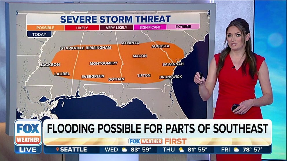
Severe storms, flooding possible across parts of Southeast on Wednesday
It's rinse and repeat across the Southeast as storms are expected again on Wednesday and Thursday. These summertime storms can be dangerous, with frequent lightning and gusty winds. These storms will also remain nearly stationary, which will allow for periods of heavy rain.
The severe weather threat wanes for much of the nation on Wednesday, with just a low risk of severe thunderstorms capable of damaging winds across parts of the Southeast, including Birmingham, Alabama and Jackson, Mississippi.

(FOX Weather)
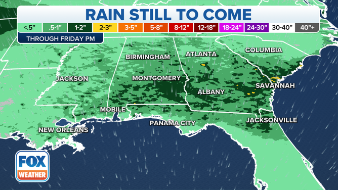
These summertime storms can be dangerous, with frequent lightning and gusty winds.
These storms will also remain nearly stationary, which will allow for periods of heavy rain and some potential for flash flooding, according to the FOX Forecast Center.
(FOX Weather)
Indications are storm coverage will begin to decrease on Friday.
A second low risk area is in the northern Plains and Rockies along a frontal boundary that stretches from South Dakota into northern Texas on Wednesday. Again, a few thunderstorms could bring damaging wind gusts to 60 mph.