Tornadoes reported in Minnesota, Nebraska as record 101-mph wind gust blasts Wichita, Kansas
Among the notable severe weather reports was a wind gust of 101 mph in Wichita, Kansas, at 4:22 a.m. CT Tuesday morning as the storms charged across the central Plains overnight and into the pre-dawn hours of Tuesday.

Weather in America: June 17, 2025
FOX Weather has you covered with the breaking forecasts and weather news headlines for your Weather in America on Tuesday, June 17, 2025. Get the latest from FOX Weather Meteorologist Britta Merwin.
Severe weather tore across portions of the Midwest on Monday and Monday night, producing tornadoes in Minnesota and Nebraska while powerful thunderstorms produced hurricane-force wind gusts and baseball-sized hail.
Among the notable severe weather reports was a wind gust of 101 mph in Wichita, Kansas, at 4:22 a.m. CT Tuesday morning as the storms charged across the central Plains overnight and into the pre-dawn hours of Tuesday.
According to the National Weather Service office in Wichita, that 101-mph wind gust tied the all-time highest gust ever recorded at Wichita Dwight D. Eisenhower National Airport. A wind gust of 101 mph was also recorded there on July 11, 1993.
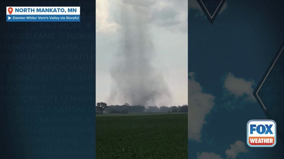
Watch: Tornado touches down in Minnesota
A video recorded in North Mankato, Minnesota, shows a tornado touching down in a field on Monday, June 16, 2025.
Severe thunderstorms developed across the Dakotas early Monday morning and continued charging east toward northern Minnesota. These early storms produced intense wind gusts across Montana. Hurricane-force wind gusts of up to 81 mph were reported in Miles City, Montana, on Sunday night.
Heading into Monday evening, severe thunderstorms brought a new threat of tornadoes.
DOWNLOAD THE FREE FOX WEATHER APP
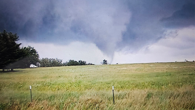
This image shows a tornado in Lake Shore, Minnesota, on Monday, June 16, 2025.
(Corey Gerken / FOX Weather)
A tornado was confirmed on the ground near Nisswa and Gull Lake, Minnesota, according to the National Weather Service, and a tornado passed in front of FOX Weather Storm Tracker Corey Gerken in Lake Shore, Minnesota.
A video recorded in North Mankato, Minnesota, showed a tornado touching down and spinning across a field on Monday.
HOW PUBLIC SAFETY OFFICIALS NOTIFY YOU DURING SEVERE WEATHER EMERGENCIES
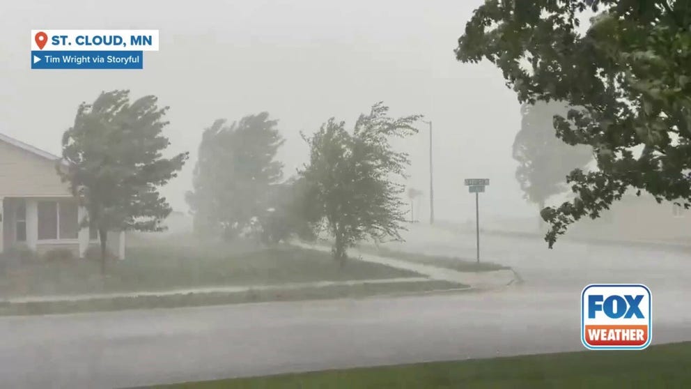
Watch: Dangerous storm slams Minnesota city with powerful winds, heavy rain
A video recorded in St. Cloud, Minnesota, shows a powerful thunderstorm racing across the city with damaging wind gusts and torrential rain on Monday, June 16, 2025.
Another video recorded in Minnesota on Monday showed a dangerous storm barreling across St. Cloud with damaging wind gusts that were causing trees to bend and sway while torrential rain fell from the sky.
Powerful thunderstorms and tornadoes were also reported in Nebraska on Monday.
![This image shows a tree branch that was brought down during severe weather in Wichita, Kansas, on Tuesday, June 17, 2025.]() Image 1 of 8
Image 1 of 8This image shows a tree branch that was brought down during severe weather in Wichita, Kansas, on Tuesday, June 17, 2025. (Kenten Webster/Facebook)
![This image shows a tree branch that was brought down during severe weather in Wichita, Kansas, on Tuesday, June 17, 2025.]() Image 2 of 8
Image 2 of 8This image shows a tree branch that was brought down during severe weather in Wichita, Kansas, on Tuesday, June 17, 2025. ( )
![This image shows a tree branch that was brought down during severe weather in Wichita, Kansas, on Tuesday, June 17, 2025.]() Image 3 of 8
Image 3 of 8This image shows a tree branch that was brought down during severe weather in Wichita, Kansas, on Tuesday, June 17, 2025. (Kenten Webster/Facebook)
![This image shows a massive tornado spinning near Dickens, Nebraska, on Monday, June 16, 2025.]() Image 4 of 8
Image 4 of 8This image shows a massive tornado spinning near Dickens, Nebraska, on Monday, June 16, 2025. (Lincoln County Sheriff's Office/Facebook)
![This image shows a massive tornado spinning near Dickens, Nebraska, on Monday, June 16, 2025.]() Image 5 of 8
Image 5 of 8This image shows a massive tornado spinning near Dickens, Nebraska, on Monday, June 16, 2025. (Lincoln County Sheriff's Office/Facebook)
![This image shows a massive tornado spinning near Dickens, Nebraska, on Monday, June 16, 2025.]() Image 6 of 8
Image 6 of 8This image shows a massive tornado spinning near Dickens, Nebraska, on Monday, June 16, 2025. (Lincoln County Sheriff's Office/Facebook)
![This image shows a tornado in Lake Shore, Minnesota, on Monday, June 16, 2025.]() Image 7 of 8
Image 7 of 8This image shows a tornado in Lake Shore, Minnesota, on Monday, June 16, 2025. (Corey Gerken)
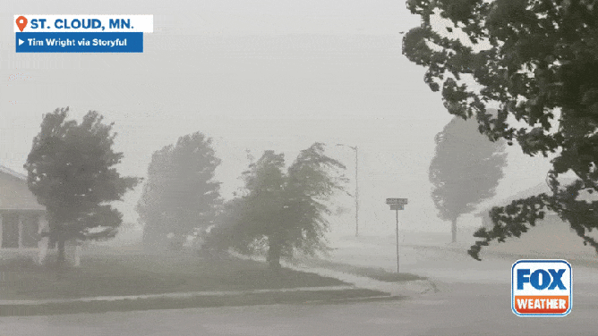
![Strong winds and heavy rain near St. Cloud, Minnesota on Monday, June 16, 2025.]() Image 8 of 8
Image 8 of 8Strong winds and heavy rain near St. Cloud, Minnesota on Monday, June 16, 2025. (Tim Wright via Storyful)


Photos shared by the Lincoln County Sheriff's Office showed a massive twister spinning across the landscape near the community of Dickens.
A mesmerizing video recorded in the area showed the tornado slowly moving across an open field while a rainbow stretched across the sky.
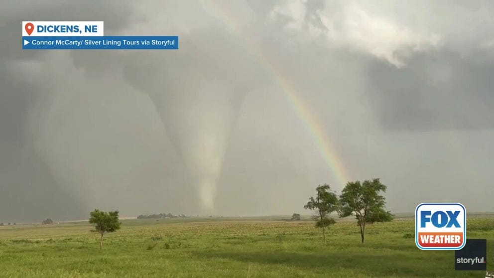
Watch: Giant tornado whirls next to rainbow in Nebraska
A large tornado was spotted spinning next to a rainbow in Dickens, Nebraska, on Monday. Video by Connor McCarty shows the towering vortex, with the rainbow adding to the shot.
That storm also produced 2.5-inch hail, which is about as large as a baseball.
The Midwest is facing a prolonged stretch of severe weather through the middle of the week, with the FOX Forecast Center warning of multiple intense thunderstorms capable of producing tornadoes, very large hail and significant flash flooding.