Saildrone's journey into Category 4 hurricane uncovers clue into rapidly intensifying storms
It turns out salt – or a lack thereof – along the ocean's surface plays a role in how hurricanes strengthen before striking the Caribbean and the southeastern US
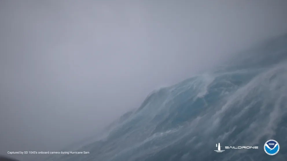
Saildrone sails into Hurricane Sam
Go inside the teeth of Hurricane Sam -- a Category 4 storm from summer, 2021, on board a Saildrone as it experiences 125 mph wind and 50 foot seas. (Video courtesy: Saildrone)
NEW ORLEANS -- Sailing an unmanned "Saildrone" into the heart of a Category 4 hurricane this summer not only brought the dramatic video of what it's like in the middle of earth's most incredible storms but is unlocking a vital clue in forecasting these major storms' development.
It turns out salt – or a lack thereof – along the ocean's surface plays a role in how hurricanes strengthen before striking the Caribbean and the southeastern United States.
Forecast models have become quite skilled at predicting a hurricane's path in recent years, but predicting a storm's intensity has still proved challenging. That's especially true when hurricanes undergo rapid intensification, defined as an increase of at least 35 mph in the peak wind speed within 24 hours.
"Pretty much all intense hurricanes, so all Category 4 and 5 hurricanes undergo rapid intensification at some during their lifetimes to bring them up to that intensity," said Gregory Foltz with NOAA's Atlantic Oceanographic and Meteorological Laboratory.
That means more intense conditions and less warning time if it happens just before landfall.
HOW ARE HURRICANES RATED? THE SAFFIR-SIMPSON HURRICANE WIND SCALE EXPLAINED
In 2018, Hurricane Michael in the Gulf of Mexico exploded in strength into a roaring Category 5 hurricane just before it made landfall along the Florida Panhandle with 160 mph wind. "And this was not a well-predicted extreme event," Foltz said.
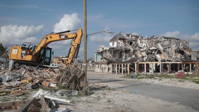
The remains of homes that were heavily damaged by Hurricane Michael remain near the beach on May 09, 2019 in Mexico Beach, Florida.
(Scott Olson / Getty Images)
To help researchers learn more about hurricanes and improve forecasts, NOAA has partnered with Saildrone to send uncrewed self-powered floating weather stations into the paths of hurricanes to collect critical weather and ocean data as hurricanes approach -- and then hopefully sail through the storm real-time data in conditions far too dangerous for human-crewed missions.
"This is storm chasing on a massive scale," said Christian Meining, Director of Engineering with NOAA's Pacific Marine Environmental Laboratory.
Researchers achieved their goal earlier in 2021 when one of their drones managed to sail right into the teeth of Hurricane Sam - a Category 4 as it swirled off Puerto Rico and would later be crowned the strongest hurricane of the year.
![]() Image 1 of 4
Image 1 of 4Saildrone sails into Hurricane Sam (Saildrone)
![]() Image 2 of 4
Image 2 of 4Saildrone sails into Hurricane Sam (Saildrone)
![]() Image 3 of 4
Image 3 of 4Saildrone sails into Hurricane Sam (Saildrone)
![]() Image 4 of 4
Image 4 of 4Saildrone sails into Hurricane Sam (Saildrone)


MORE: 50-foot waves and 120 mph wind: Saildrone video takes us inside Hurricane Sam
The drone made it to Sam's northeastern eyewall -- the most intense part of the storm. The data the drone sent back was incredible -- and not just from providing an eyewitness account of what it's like to sail in the middle of 125 mph winds and 50-foot seas of a major hurricane. Still, the analysis of the ocean waters provided some crucial details.
The waters where Sam intensified were lacking in… salt.
Hurricanes thrive on the energy provided by warm tropical waters to survive and grow. But researchers find they can get a boost as freshwater from major rivers such as the Amazon, Orinoco and Mississippi flow into the ocean where hurricanes tread.
Less saltwater near the surface and saltier water at deeper layers act like a barrier, restricting colder, more salted water to mix to the surface when storms pass.
The result is a layer of warmer water near the surface. "This provides more energy and more fuel for the hurricane and makes it more likely to rapidly intensify," Foltz said.
This comes as scientists predict climate change will make the rapid intensification of hurricanes more frequent. Today, a hurricane may undergo extreme rapid intensification of 70 mph in 24 hours about once every 100 years. NOAA says it may become as common as a one in every 5-10 year occurrence by 2100.
Researchers now hope to use Saildrones in combination with other tools such as underwater gliders that can record ocean conditions as deep as 3,000 meters (9,800 feet) and hurricane hunters and satellites to paint a complete picture of the atmosphere and oceans -- including water salinity -- to feed into forecast models, giving the computers crucial data for more accurate hurricane forecasts.
"Ultimately, by continuing to innovate together; science and engineers, pilots, governments, academia and industry, we can push the limit of what's possible to advance the science and engineering to make everyday lives better," Meining said. "And as these extreme events increase over time, we can advance the forecast models that can save lives and property."