'Ring of fire' ignites tornadoes across northern, southern US as drenching storms stretch thousands of miles
Across the northern tier of the country, severe weather watches stretched from Nebraska through western Wisconsin and included a Tornado Watch south of Minneapolis.

Drenching storms stretch thousands of miles along ring of fire
A strong ridge of high pressure has settled across the East, bringing record-breaking heat through the first half of this week. Meanwhile, storms tracking around the periphery of this ridge or ring of fire bring flash flooding and severe weather from the Plains into the Midwest and along the Southeast.
Rounds of severe storms developed over the northern and southern tiers of the U.S. on Wednesday as a large dome of high pressure was parked across the East, the FOX Forecast Center said.
Across the northern tier of the country, severe weather watches stretched from Nebraska through western Wisconsin and included a Tornado Watch south of Minneapolis.

Watch: Tornado tears through Hartland, Minnesota, on Wednesday
Multiple tornadoes were reported by the National Weather Service in southeastern Minnesota on Wednesday afternoon. Video footage from Hartland, Minnesota, shows a tornado towering over a car with debris swirling in the air. A Tornado Warning for the area expired at 5 p.m. Wednesday.
A rare Flash Flood Emergency was issued in parts of Nebraska on Wednesday after several inches of rain fell in less than a day, causing many roads in the Grand Island area to become impassable due to flooding. The Grand Island Police Department took to social media on Wednesday night to urge people to stay home and stay safe due to the potentially dangerous situation.

Watch: Roads flooded amid Flash Flood Emergency in Nebraska
A video shared from Grand Island, Nebraska, shows flooded roads near homes amid a Flash Flood Emergency on Thursday, June 26, 2025.
An unexpected tornado tore through parts of Pinellas County, Florida, on Wednesday, damaging dozens of homes and leaving a trail of destruction in neighborhoods west of Tampa. The severe thunderstorm moved through the area during the early evening, spawning the twister that heavily impacted mobile home communities in the Pinellas Park area.
After the severe weather, emergency crews were seen going door to door to check for potential storm victims. As of Wednesday evening, authorities did not report any significant injuries associated with the unwarned cell.

Debris spotted swirling from Florida tornado
An unexpected tornado tore through parts of Pinellas County on Wednesday, damaging dozens of homes and leaving a trail of destruction in neighborhoods west of Tampa.
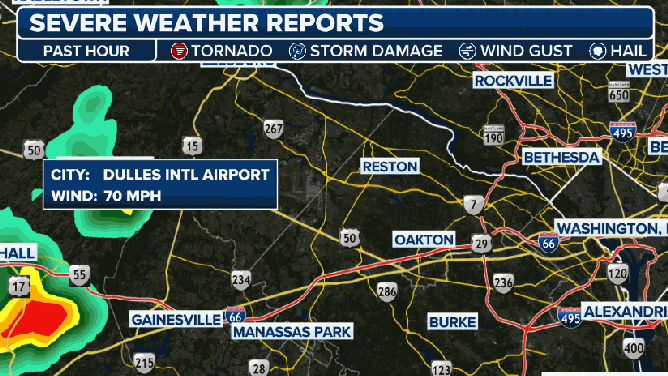
On Wednesday afternoon, a severe thunderstorm outside of Washington, D.C., caused a wind gust of 70 mph at Washington Dulles International Airport in northern Virginia. Power outages topped 20,000 in the state as thunderstorms worked in the general direction from north to south.
Severe storm outside of Washington, D.C. on 6/25/2025.
(FOX Weather)
Multiple tornadoes were reported in southern Minnesota, with at least one barn destroyed by the severe weather.
Residents in Hartland, Minnesota, took photos and video of the twisters as they moved through Freeborn County, located southwest of Rochester. One of the narrow-shaped vortexes appeared to move through an open field as the thunderstorms generally worked from southwest to northeast on the northwest side of the ridge of high pressure.
![Tornado seen from Hartland, MN on Wednesday.]() Image 1 of 2
Image 1 of 2Tornado seen from Hartland, MN on Wednesday. (Nicole Madson)
![Tornado west of Hartland, MN on 6/25/2025.]() Image 2 of 2
Image 2 of 2Tornado west of Hartland, MN on 6/25/2025. (@Eye_goh6030)


As the ridge of high pressure continues to break down, afternoon storms will remain in the forecast into the end of the week, the FOX Forecast Center said.