Remnants of Tropical Storm Hilary may help clear choking wildfire smoke in Pacific Northwest
Air quality dropped to unhealthy, or even hazardous, levels in the Pacific Northwest Sunday into Monday as smoke from several wildfires burning in the area smothered millions, including Seattle and Portland.
Remnants of Tropical Storm Hilary heading for Pacific Northwest
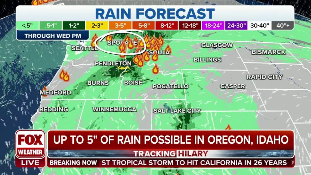
Flood Watches are in effect for parts of Oregon, Washington and Idaho as a batch of heavy rains moves into the inland Northwest due to the remnants of Tropical Storm Hilary.
SEATTLE -- Air quality dropped to unhealthy, or even hazardous, levels in the Pacific Northwest Sunday into Monday as smoke from several wildfires burning in the area smothered millions, including Seattle and Portland. But some temporary relief may be on the way for parts of the region from the remnants of Hilary.
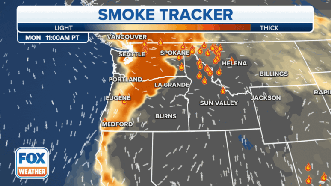
The worst air quality conditions Monday morning were in Eastern Washington and Oregon, where widespread air quality index readings were over 200 -- signaling very unhealthy air quality, with some locations experiencing "hazardous" air with AQI's over 300.
WHAT IS THE AIR QUALITY INDEX?
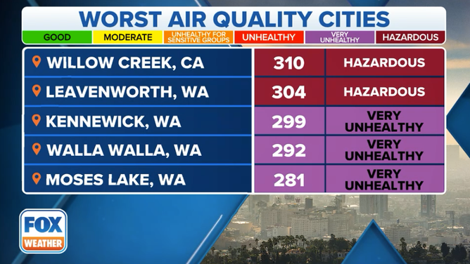
Current worst air quality readings in the U.S. at 6 a.m. PT on Aug. 23, 2023.
In Seattle, the skyline disappeared in an orange, smoky haze Sunday evening as smoke poured in from the east.
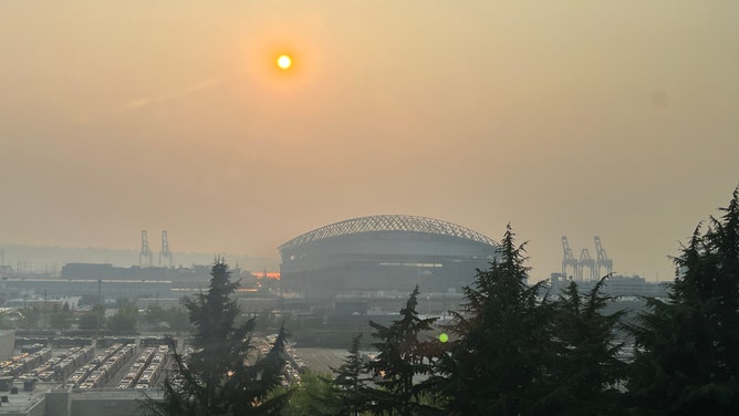
An orange-tinged sun sets over a smoke-covered Seattle skyline on Aug. 20, 2023.
(Scarlett Sistek / FOX Weather)
AQI's were in the "unhealthy" range of over 150 Sunday evening into Monday morning. Spokane also had AQIs over 150 Monday morning. Air Quality Alerts remain in effect for much of the region Monday.
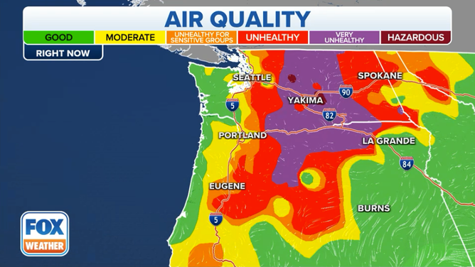
Air quality readings at 5 a.m. PDT on Aug. 23, 2023.
(FOX Weather)
Several wildfires continued to burn across the Pacific Northwest and southern British Columbia, leaving the region vulnerable to smoky days. Two people were killed, and dozens of homes have been burned in fires in Eastern Washington. The Gray Fire in Medical Lake, Washington has burned nearly 11,000 acres and is responsible for at least one death.
AT LEAST 2 KILLED, HUNDREDS OF STRUCTURES LOST DURING WASHINGTON STATE WILDFIRES
The Oregon Road Fire to the north of Spokane has burned over 10,000 acres. At least one person was found dead in a burn zone near the town of Elk, a state DNR spokesperson said Sunday evening.
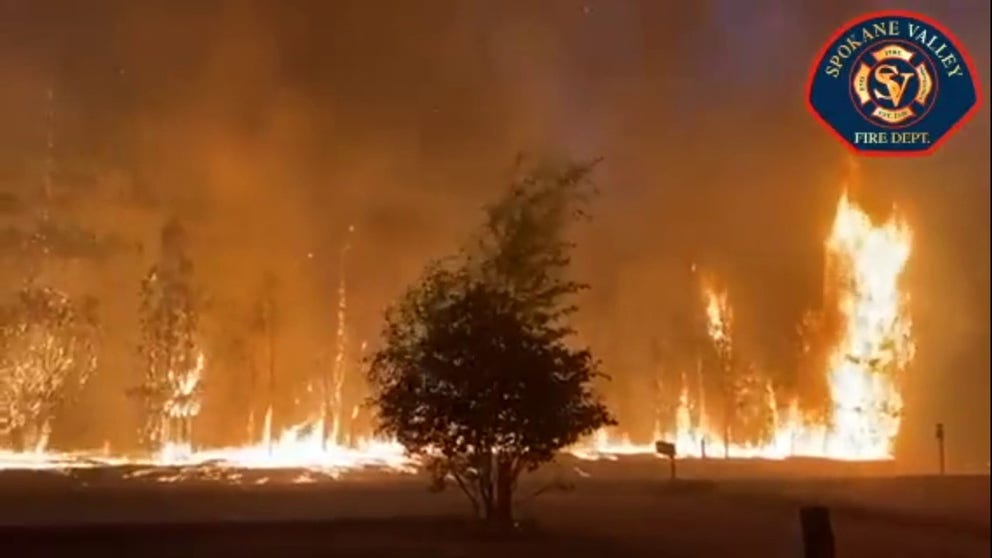
Oregon Road Fire burning in eastern Washington
The Oregon Road Fire has burned nearly 10,000 acres in eastern Washington state and has been blamed for at least one death according to DNR spokesperson.
Meanwhile, officials in British Columbia report nearly 400 active wildfires remain in the province, with over 140 considered still out of control.
Some relief comes via remnants of Tropical Storm Hilary
While thick smoke was still an issue on Monday, some improvement was expected Tuesday on both sides of the Cascades. In the Seattle and Portland I-5 corridor, an increase in westerly ocean breezes Monday night will sweep the smoke out the east and usher in cleaner air.
But east of the Cascades, rain showers from the remnants of what is now Post-Tropical Cyclone Hilary are forecast to dampen the raging fires and fan out the smoke a bit. Hilary was at its peak a Category 4 hurricane off the Mexican coast and pushed into Southern California Sunday as a tropical storm, bringing torrential rains and flash flooding.

(FOX Weather)
Unfortunately, flash flooding is also a risk for portions of the Pacific Northwest as Hilary's remnants push into the Pacific Northwest.

(FOX Weather)
Flood Watches are in effect for large portions of eastern Oregon and western Idaho, plus a few counties in southeastern Washington. Rainfall totals could reach 2-3 inches in the Flood Watch areas.
The flood watch does not cover the areas where the Gray and Oregon Road fires are burning, but around a tenth to a quarter inch of rain is possible on the fire lines.
However, drier and warmer weather is forecast to return later in the week, increasing fire danger once again. Long-range forecasts indicate a chance of showers and thunderstorms over the weekend as the air mass destabilizes.